Eastern flank, looking approx north...
Image credit: Robert Gladstone
Eastern flank, looking approx north...

South-eastern flank, looking approx east.

Eastern flank, looking approx south in appaling conditions...

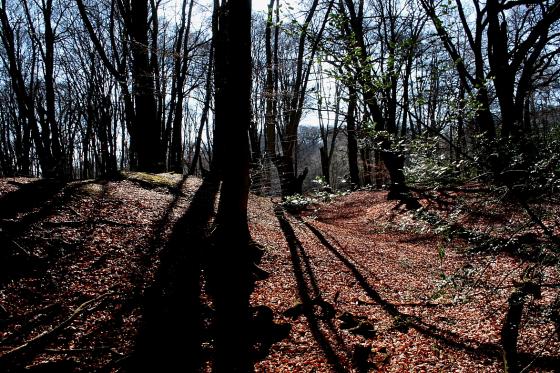
The severely trashed north-eastern flank, with cricket nets for company.

South-eastern flank, looking very approx west.

This image sums up the South Weald Camp hillfort for me – a broken remnant of its former self.... but nonetheless possessing the ability to ‘speak’ to the part of us which cannot be defined, yet surely defines us as a species. Paradoxical, or what?


Trashed it may be, but this enclosure still impresses.

South-south-east..... bordering the cricket ground. Very overgrown, behind barbed wire.

North-west. The rampart is very substantial here........

To approx north-west.


South-western rampart. Not bad.

I first came to South Weald Camp to see the ramparts adorned with the bluebells of Spring... unfortunately, however, I left knowing that I would have to return at some point in order to settle unfinished business. If you’ve read the miscellaneous post you’ll be aware that this Late Iron Age enclosure has not had an easy ride into the 21st Century. Far from it. Now medieval alterations, I can accept.... but a cricket pitch occupying the eastern half of an Essex plateau fort? Do me a favour. People supposedly intelligent enough to play cricket should really know better, should they not? Having said that, though, this Modern Antiquarian should have had the balls to highlight this discrepancy back in April. But, to my shame, I bottled it and went away with the job half done.
Consequently I engineer the return home this New Year’s Day – following a morning at Old Harlow’s fine round barrow – so as to pass through Brentwood. A little before the town a minor road leaves the A128 to literally bisect South Weald Camp. It is possible to park just south of the enclosure, from whence a rather idiosyncratic stile affords a visit to the western half of the camp. To avail yourself of the eastern half, walk back up the road and make for the cricket club pavilion, G&Ts at the ready. As it happens, today being New Year’s Day and all, there is no one around. So I reckon no-one is therefore going to mind me having a quick look at my local heritage. A metal gate to the south gives access to a muddy track following the outside perimeter of the camp. Although badly damaged, the south-eastern arc of the bank is still pretty substantial... the eastern defences more so, although possible medieval amendments should be bourne in mind, I guess. Only to the north is the bank truly trashed, having the indignity of being sandwiched between practice cricket nets. Howzat? Very nearly ‘out’. But not quite.
It begins to rain... as forecasted.... and then, to all intents and purposes, monsoon. Which I don’t recall being mentioned. But there you are. Nevertheless I can’t leave without another visit to the western half of the camp, if only for the sake of continuity. No bluebells on this occasion, the ramparts rising stark within the landscape, trees offering skeletal profiles in Winter raiment. My dodgy ‘hillfort-allocation’ waterproofs begin to give way under the prolonged onslaught of the rain. But it is of little consequence. I am happy I’ve now seen the whole picture, as it were.
Yeah, poor South Weald Camp may have been dealt a poor hand by fate, but I reckon it’s still well worth an hour or so of anyone’s time.
Just flagging the existance of this really – I’m not even sure what the real name should be.
On the OS map it is marked fort, but I was unable to find much else out about it really. the Maps in the park mark it as an Iron-Age Hill Fort but there was nothing in the visitors centre about the fort.
From the public carparks it is a fair walk to the earthwork. The ditches use the natural contours to create some very steep banks 3-4 meters high in places. The site has a road running straight through it.
Poor South Weald Camp has been badly treated by the passage of time, of that there can be no doubt. Firstly, by its incorporation within a deer park in medieval times, then by having a road driven through its centre... and last but not least... by having its eastern half remodelled as a cricket ground! To be honest, it’s a wonder anything exists at all.... but thankfully it does.
The western half of the enclosure can be freely visited, lying as it does within the Weald Park Country Park. Not so the eastern, since the cricketing chaps would no doubt think it very bad form if a traveller was to go walkabout during a game. However I’d suggest the whole of the enclosure is worth seeing. And it costs nothing to ask permission, does it not?
Essex HER [SMR 531] has quite a bit of data regarding the site, including:
‘On high ground partly within the eastern boundary of Weald Park. It is approximately circular, enclosing about 7 acres. On the east side is a rampart and steep scarp. If there was an external ditch it has gone, the northern section of defences has almost disappeared. The site of the entrance is doubtful.Two trenches were excavated across the defensive ditches in 1990 in an attempt to confirm the Late Iron Age date. Three years after the excavation, a detailed contour survey of the earthwork and its immediate environs was undertaken as part of a separate project aimed at assessing the archaeological potential of the Essex Country Parks.The two trenches excavated sectioned the univallate defences in the north-west and south-west quadrants. Both the excavations and the contour survey date the beginning of the construction of the hillfort to the Late Iron Age. Dating is provided by small amounts of Late Iron Age pottery in the rampart make-up. One trench had a well-defined linear cut interpreted as a slot for a revetment at the rear of the rampart. Within the area enclosed by ditch and rampart were a number of post holes also dated to the late iron Age; they may represent internal structures.
[FAU. 1994. South Weald Surface Model; Medlycott, Maria et al. 1995. South Weald camp – probable late Iron Age hill-fort; excavations 1990; Isserlin, RMJ. 1995. South Weald Camp, Brentwood and Langdon Hills, Basildon: Analytical Earthwork Survey.]‘