The cairn at ST 29135 58925 on the eastern summit is very prominent when seen from the path on the lower slopes of the Down.
Image credit: A. Brookes (23.2.2019)
The cairn at ST 29135 58925 on the eastern summit is very prominent when seen from the path on the lower slopes of the Down.

The summit cairn, looking towards Weston-super-Mare and Worlebury.

The cairn on the highest point of Brean Down.

Small barrow near the western summit at ST 28519 59010, looking towards Weston-super-Mare and the lower eastern summit.

The cairn on the eastern summit at ST 29135 58925.

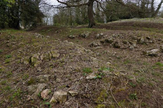
Cairn at the western end of the eastern summit (ST 29135 58925), looking towards the higher western summit.

Small barrow or clearance cairn on the eastern summit.

Another view of the barrow at ST 29325 58814.

The most prominent barrow on the eastern summit, at ST 29325 58814. This is the one the Rev. Skinner dug.

Brean Down seen at low tide from Weston-super-Mare, Late August Bank Holiday Monday


Bronze Age Barrow on Brean Down

Brean Down from the beach at Weston-Super-Mare – 28.12.2003

Brean Down from the beach at Weston-Super-Mare – 28.12.2003


The Brean Down promontory seen from Brean.
Whilst on a short camping holiday two years ago on a campsite on Brean Down I took the opportunity to walk along the headland. There is a car park at the base of the cliffs next to tropical bird garden / cafe. You then need to undertake a very steep set of steps which take you to the top. Just as you get to the top of the steps there are the remains of a small hillfort to be seen – corner section. Only small but fairly well preserved. I also managed to obtain a N.T. visitor leaflet on the site from the cafe. This gave details of the prehistoric, Roman and WW2 defences found on the headland. It’s quite a long walk but there is a circular walkway which takes you right around the headland and past the various sites. A good way to spend and hour or two.
I was in the area recently and discovered that the original dyked road (incidentally recorded by Dion Fortune in Sea Priestess) from Brean Down alongside and across the River Axe is – quite astonishingly – still in situ. Walking past the entrance to the military road towards Brean Down Farm, one comes to an earth bank at the farm entrance. From the top of the bank, one can see across the Axe, the mudflats and the saltings to the village of Uphill. To the right is the embankment that the road was carried on – the road is still plainly visible, grass grown as Fortune records, and as it must have been since its construction. One can walk along the road round a big loop of the Axe, all the way to Brean Cross Sluice, which I believe was once the site of a bridge. At high tide the mudflats are submerged and the saltings are awash – it would only require a mist to hide the holiday accommodation at Uphill to begin to visualise what the area must have been like in the past.
I was last here a few years ago, on a bit of a random day out, we just stumbled across the place. A few weeks later I read about Brean Down in Ronald Hutton’s excellent ‘Pagan Religions of the Ancient British Isles’. In the book the focus is mainly on the Romano-British temple that once stood here, but very close by is a Bronze Age barrow, and there may well have been more. The temple fell into ruin and was built over with a christian shrine. This too has now completely gone. So in terms of sacred sites, there isn’t a lot to see. However in terms of the sacred landscape this place is completely awe inspiring – I can’t think of many places I have visited which are quite so elemental. You really do feel on top of the world gazing over the edge. The vastness of the sea stretches out before you, and behind the flat marshy plains of the Somerset levels with Brent Knoll clearly visible in the distance, itself the home to an Iron Age fort.
As we left Brean Down the wind howled and a storm was starting to blow in from way out at sea. This is a truly heathen place.
The Berrow Flats are the huge expanse of sand that abuts Brean Down. I read this folklore in Ruth Tongue’s ‘Forgotten Folk Tales of the English Counties’ (1970) and it also reminded me of the fishermen’s lore associated with Worlebury, the next headland north.
“My father used to tell us that there was a big fish of Berrow Sands and it had a huge mouth. It used to swallow all the fish and the sailors too, and what it didn’t finish, the conger eels did. They used to bark at those times and people knew the big fish was hungry and the fishermen were in danger. Well, there was a bold fisherman who went out in his little boat and the big fish opened his great mouth to take him and he cast his anchor down its throat and the cold iron finished it.”
Told to RT by Brean WI members.
You will notice the mention of ‘cold iron’ – always good against the fairies too – the power of metalworking! And the conger eel, which is also mentioned in the folklore of Wookey Hole.
There are two distinct groups of barrows on Brean Down, located on the eastern and western summits of the ridge. Pastscape descriptions:
Eastern group
Seven mounds are contained within the eastern field system on Brean Down. One of these is a round barrow, centred at ST 29325 58814. It is most likely to be the site that Skinner, writing in the early 19th century, found Roman pottery and human bones on the surface, and recorded that the primary deposit had been removed. The barrow lies just to the south of the Roman temple (ST 25 NE 6) and appears to overlie part of the field sytem. The NW side of the barrow has been damaged by ridge and furrow cultivation. A small hollow at the SE corner of the barrow represents the remains of a small building, visible on aerial photographs taken in 1948. Four small depressions on the W and E sides of the mound and to the S of the barrow probably mark the position of ApSimon’s trial trenches.
The mound centred at ST 29135 58925 may be a burial cairn. It is portrayed thus on a map of 1821. Silty clay has been dumped on the W end of the mound, obscuring its original form.
The remaining mounds are all small and are most likely to be clearance cairns or modified field banks. The mound centred at ST 2932 5881 is larger than the others, measuring 15m in diameter, has been interpreted as a round barrow or cairn which may be Bronze Age or Roman in date.
The other four mounds are centred at ST 2911 5893, ST 2913 5892, ST 2921 5889 and ST 2924 5887. They are predominantly sub-circular except for the largest mound and range in size, measuring between 3m in diameter and 7m by 10m. The largest of the mounds has been interpreted as a Bronze age burial mound. The other mounds may be clearance cairns which are possibly later in date.
Western group
Six mounds are contained within the western field system on Brean Down. Two of these are most likely to be small, Bronze Age burial cairns. The cairn at ST 28412 50920 is a low, circular, stony mound, close to a field bank. The cairn at ST 28519 59010 is a circular, turf-covered mound. Both of these cairns are shown on Colt Hoare’s map of 1821 as burial cairns.The large, flat-topped, sub-rectangular mound at ST 28487 59007 is surmounted by an OS trig. pillar. The hollow and small mound by the pillar suggest that the mound has been dug into. The field system may have incorporated an earlier cairn, or it may have been altered by the addition of a large burial cairn. The mound may have been augmented by field clearance. The present day appearance of the mound suggests that it may have been used as a beacon during the post medieval period.
The small rectangular mound on top of a field bank at ST 28647 58955 appears to be of recent construction. The mound at ST 28695 58942 is caused by the junction of two field banks, although it may have been augmented by field clearance. The sub-rectangular mound at ST 28733 58937 is part of a field bank, perhaps augmented by field clearance. A small hollow in its centre suggests that it has been dug into, and its northern end appears to have been modified by the removal of material.
Brean Down is the setting for Dion Fortune’s 1938 esoteric novel The Sea Priestess.
Brean Down was essentially an island up until the medieval period when the surrounding land was drained for agricultural purposes. The thought of having to paddle through foggy swamp to this remote, stormy place is quite something!
In 1896 Marconi made the word’s first radio transmission from Brean Down to Lavernock Point, Penarth.
You can download the EH monograph ‘Brean Down: Excavations 1983-1987’ by Martin Bell from the ADS website. He calls the site “the best preserved Bronze Age settlement sequence in Southern Britain”, with five prehistoric occupation phases amidst 5m of blown sand and eroded soil.