
As bonus sites go, this is surely up there with the best?
Image credit: Robert Gladstone
As bonus sites go, this is surely up there with the best?

If this isn’t a long cairn I’ll eat my hat.

From the east.
Looking NNE.

The southern end of the mound, looking down on Marros Sands.

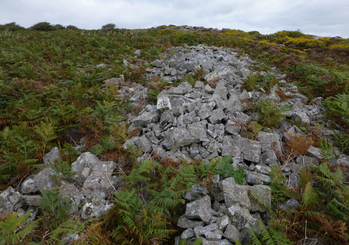
Looking SSW along the long mound.

First sight of the cairn, looking SSW towards Caldey Island and Tenby.
Despite there being no reference to this ‘long cairn’ upon Coflein, I must admit this ticked every consideration ‘box’ I look for nowadays. It’s therefore of interest to note that the good people at Dyfed Archaeological Trust feel the same way – PRN 11430 states:
“A well preserved trapezoidal long cairn, orientated SW-NE, with the broadest end looking NE. The tail end of the monument faces SW and looks out to the sea, whilst tapering to a width of 5m. At the end of the tomb which increases to a width of 8m, there appears to be a shallow forecourt area, 3.5m wide and 3.5m deep, which is delimited on either side by two distinct horns. In other similar monument traditions (e.g the Cotswold-Severn tombs) this forecourt area is generally considered to be the spatial focus of the ceremonial and ritual activities which took place at these sites during the Neolithic and Bronze Age. The forecourt also looks towards the edge of the limestone escarpment immediately below which, Tomb D (3825) is located, which makes use of the natural outcrop for part of its form. A central spine runs along the length of the cairn and there are indications of the tumble of some of the cairn material on both sides. Although there is no immediately apparent evidence for an orthostatic chamber or passage within the monument, it is possible that there may be one or more cist chambers within the body of the cairn material instead, a feature familiar at other Neolithic long cairns known from a Welsh context. There is some damage at the SW end of the cairn where the cairn appears to have been dug into on both sides, 2 metres in from the tail. All the evidence points to this site as being a genuine Neolithic long cairn rather than a more modern clearance cairn. Bestley PFRS 2001”


