
Image credit: Robert Gladstone

The entrance... obviously.


The broch in its landscape. Note Eilean Donan castle beyond... bearing traces of vitrified stonework. Clearly the owners of both sites wanted control of the meeting of the lochs. Incidentally the near green crag is depicted upon the broch’s reconstruction drawing (on site) as bearing a contemporary settlement...

An exposed section of gallery at Caisteal Gruagaig.
This is a panorama created from three photographs taken from the top of the rear wall of Caisteal Gruagaig.

Complementary to the not too distant Glenelg brochs.... substantial site, this.


The most accessible mural passage... complete with steps.


Mural passage... definately a broch, then.

This is the way, step inside....

The entrance is visible to left, one of the accesses to mural passage far right.

A nice triangular lintel... every desirable broch needed one back in Iron Age. Apparently.

Substantial stone work...
Following a reasonably satisfying hors d’oeuvre at Torran a’Bharraich I continue loch side upon the minor road as it winds through the village of Letterfearn.... only for progress to be abruptly halted at a locked gate beyond Druidaig Lodge. Despite the appropriate name, I’m confused since the map shows this road terminating at the hamlet of Totaig. The usual self doubt regarding navigational prowess – or rather lack of it – rears its ugly head. Surely I haven’t made a mess of this? I decide not. But there’s only one way to find out conclusively..... so, boots donned, I step out into the deluge (after parking a little way back up the road). It is actually a rather good, scenic walk to Totaig offering excellent views across the water to the gaunt, albeit restored, fortress of Eilean Donan. Totaig’s few buildings appear deserted, uninhabited nowadays, although those with a bit of spare cash – OK, perhaps more than a ‘bit’ – could find themselves a perfect, idyllic hideaway here. Any rich widows fancy some company? The track, now unmetalled, ascends the hillside to the left as the traveller approaches. I head for what is ‘obviously’ the site of the broch – where I would have placed it – across the inlet (Eilein Aoinidh) only to discover I am just as obviously wrong, the broch visible set into the hillside to the approx south-west [although, to be fair, a reconstruction drawing at the broch depicts round houses here, presumably the dwellings of lesser kinsmen].
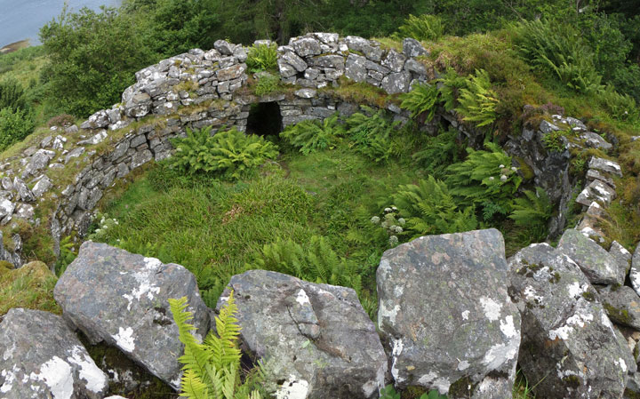
Caisteal Grugaig occupies a fine, strategic location above a cascading stream (that’s the water source sorted, then) commanding the confluence of Lochs Duich, Alsh and Long below to the approx north-east and thus, presumably, the maritime traffic back in the day. The relationship with Eilean Donan, the island apparently featuring traces of vitrified stonework beneath the restored castle, is intriguing. Did one family occupy both sites, assuming they were contemporary? Or were they rivals? Sadly, as far as I’m aware, the Iron Age remnants surviving upon Eilean Donan are minimal. Not so this broch, the substantial nature of the remains of which come as a very welcome surprise. Very often in this game the archaeology doesn’t match the scenic splendour, or vice versa. But not here. OK, the structure is nowhere near as tall as the wondrous, not too distant Glenelg brochs, but nevertheless bears very favourable comparison with most other mainland brochs that I have seen to date. Furthermore many of those idiosyncratic hallmark features of these iconic structures are very much present and correct. All the boxes ticked, so to speak.
Firstly, starting logically at the entrance, there is a fine, triangular lintel reminiscent of that at Dun Dornadilla, sited below Ben Hope far to the north. Yeah, perhaps this detail was de rigueur amongst fashionable broch owners? The entrance passage retains draw-bar holes to secure a heavy door and a guard cell formerly housing, er, guards visible to the left (albeit more or less now inaccessible). Within the broch irregular outcrops of bedrock remain in situ suggesting the ground level was used for storage. A trio of internal doorways allow access to a mural passage and staircase servicing the upper floor(s?) and a couple of mural chambers. It is possible to clamber up the stairs to the wall top, lethally slippery in the rain, and muse upon the mentality, the differing hopes and dreams of the people who occupied this defensive dwelling two millennia ago.
Surprisingly the broch plays host to several more visitors during my stay; a quartet of middle-aged hikers seemingly quite ‘taken’ by it, to be honest (good for them, I say); and an older dude, white hair pulled back in a pony tail, together with his wife and dogs... with whom I shared Mam Ratagan last night. Good, proper people. See, they do exist.
Before leaving Caisteal Grugaig it is worth ascending the track a little further to the hill top above and to the right, passing an information board en route. This affords an excellent view of Loch Alsh and the magical Isle of Skye to the west, together with a grandstand panorama of ‘the meeting of the lochs’ – and Caisteal Grugaig’s place in the landscape – to the east. The mind races as I imagine the scene as those three Hanoverian frigates pounded Eilean Donan to rubble in May 1719....


