The Modern Antiquarian
Log in
|
Register
Home
Latest Posts
Forums
Maps
Help
Browse Sites
News
Blog
Contributors
The Books
Select
-
Belgium
Denmark
Eire
France
Germany
Greece
Italy
The Netherlands
Norway
Portugal
Republic of Malta
Spain
Sweden
Switzerland
United Kingdom
County Limerick
Tory Hill
Hillfort
Tory Hill (Hillfort) on The Modern Antiquarian, the UK & Ireland's most popular megalithic community website. 1 image, 1 fieldnote, plus information on many more ancient sites nearby and across the UK & Ireland.
Image © Bawn79 © 2008
Nearest Town:
Croom (3km SW)
OS Ref (IE):
R533428 /
Sheet: 65
Latitude:
52° 32' 4.75" N
Longitude:
8° 41' 17.83" W
Added by
bawn79
Images (1)
Fieldnotes (1)
0 discussions
Start a topic
Show |
Hide
Web searches for Tory Hill
Flickr
Google
Google Images
The Megalithic Portal
Bing
Stone Pages
Wikipedia
Show map
(inline Google Map)
- Sites within 20 km -
-
Rathmore South (4.02km E) (3 posts)
Adare Manor (6.73km W) (8 posts)
Bawnacouma (7.28km NE) (1 post)
Friarstown (8.07km NE) (6 posts)
Rockbarton (8.95km E) (3 posts)
Grange Lios (10.13km E) (9 posts)
Knockfeerina (10.14km SW) (7 posts)
Clorhane (10.16km WNW) (2 posts)
Clorhane (10.16km WNW) (4 posts)
The Stone Of The Tree (10.25km E) (6 posts)
The Pillar Stone (10.26km E) (8 posts)
Ballinculloo (10.27km SE) (4 posts)
Knocktwo (10.3km ESE) (3 posts)
Buachaill Bréige (10.42km SW) (7 posts)
Knockfeerina (10.42km SW) (11 posts)
Knockfennel (10.48km E) (4 posts)
Knockfennel (10.58km E) (2 posts)
Knockfennel North (10.73km E) (4 posts)
Lough Gur C (10.79km E) (17 posts)
Lough Gur D (10.79km E) (6 posts)
Lough Gur Wedge Tomb (10.81km E) (26 posts)
Grange / Lios, Lough Gur (10.81km E) (87 posts)
Ballingoola B (10.96km ENE) (1 post)
Ballingoola C (10.96km ENE) (1 post)
Ballingoola D (10.97km ENE) (0 posts)
Black Sow’s Bed (10.98km E) (6 posts)
Ballingoola E (10.98km ENE) (1 post)
Knockfennel (11.02km E) (3 posts)
Ballingoola A (11.06km E) (2 posts)
Ballingoola (11.06km ENE) (1 post)
Old Hags Chair (11.14km E) (2 posts)
Knockadoon Circle K (11.16km E) (5 posts)
Entrance to Tir Na Og (11.27km E) (3 posts)
Knockadoon Circles A + B (11.27km E) (1 post)
Stonepark (11.28km ENE) (2 posts)
Knockadoon (11.33km E) (1 post)
Bruff (11.63km ESE) (3 posts)
Lough Gur O (12.07km E) (8 posts)
Luddenmore (12.09km ENE) (3 posts)
Luddenmore (12.09km ENE) (5 posts)
Lough Gur P (12.11km E) (1 post)
Carraig Aille (12.12km E) (4 posts)
Carraig Aille (12.12km E) (7 posts)
Tynacocka (12.21km ESE) (2 posts)
Grillagh (12.31km E) (0 posts)
Ballybricken West (12.32km ENE) (3 posts)
Loughgur (12.39km E) (0 posts)
Ballybricken East (12.8km ENE) (3 posts)
Ballybricken East (12.82km ENE) (2 posts)
Brufea (12.97km ENE) (3 posts)
Ballybricken East (12.98km ENE) (4 posts)
Knockroe (13.1km ENE) (2 posts)
Knockroe (13.23km ENE) (2 posts)
Castletown (13.29km SW) (4 posts)
Curraghchase (13.33km W) (3 posts)
Knockroe (13.42km ENE) (7 posts)
Inch (13.42km ENE) (5 posts)
Knockroe (13.51km E) (3 posts)
Moohane (13.67km E) (4 posts)
Inch St. Lawrence (13.91km ENE) (7 posts)
Highpark (14.02km ENE) (4 posts)
Highpark (14.27km ENE) (3 posts)
Highpark (14.44km ENE) (2 posts)
Skahard (14.52km ENE) (3 posts)
Highpark (14.52km ENE) (1 post)
Cnoc Aine (14.76km E) (2 posts)
Cnoc Aine (15.07km E) (1 post)
Cnoc Aine (15.07km E) (3 posts)
Knocksouna (15.17km SSE) (1 post)
Cnoc Aine (15.57km E) (7 posts)
Rootiagh (15.58km E) (3 posts)
Cnoc Aine (15.66km E) (6 posts)
Caherclogh (15.69km SW) (2 posts)
Cloghaunainey (15.7km E) (1 post)
Ballyvocogue (15.87km W) (1 post)
Rootiagh (15.98km E) (1 post)
Bulgadenhall (16.23km ESE) (1 post)
Ballynamona (16.7km E) (4 posts)
Gorteennacreeagh (17.12km E) (2 posts)
Castlefarm (17.14km E) (4 posts)
Knockeen (18.08km ENE) (1 post)
Rathanny (18.1km E) (7 posts)
Ballinscaula (18.42km ESE) (6 posts)
Ballinscaula (18.42km ESE) (2 posts)
Lodge (18.52km E) (4 posts)
Gotoon (18.73km E) (2 posts)
Longstone (19.12km ENE) (2 posts)
Coolalough (19.22km E) (2 posts)
Coolalough (19.28km E) (2 posts)
Ballinvana (19.34km ESE) (2 posts)
Hospital (19.47km E) (2 posts)
Elton (19.5km ESE) (6 posts)
Craughaun Cemetery (19.53km NW) (2 posts)
- Add -
-
Add news
Add an image
Add fieldnotes
Add folklore
Add miscellaneous
Add a link
-
Add a site
Add a nearby facility
Add an alternative name/spelling
Images
(click to view fullsize)
Add an image
Fieldnotes
Add fieldnotes
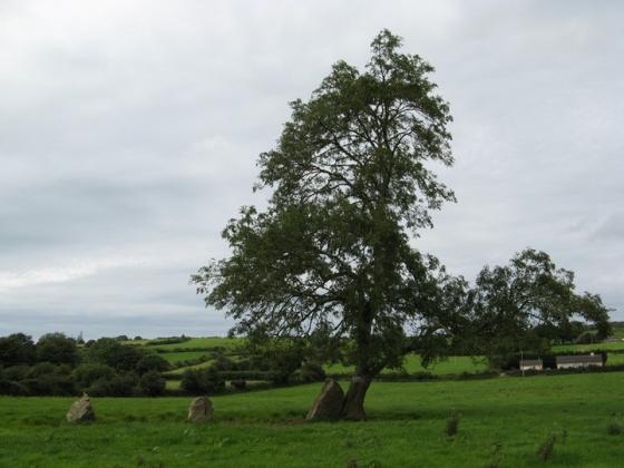
I believe the fort on this is marked as a ceremonial enclosure. What I find most interesting about this site is that it is the one major hill between Ballyhouras/Knockfeerina and the high lands around Lough Gur.
Comments (0)
|
Add a comment
|
Permalink
Posted by
bawn79
23rd April 2008ce