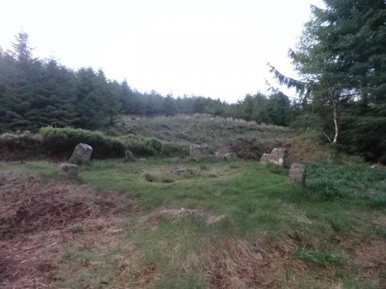
The Modern Antiquarian
Log in
|
Register
Home
Latest Posts
Forums
Maps
Help
Browse Sites
News
Blog
Contributors
The Books
Select
-
Belgium
Denmark
Eire
France
Germany
Greece
Italy
The Netherlands
Norway
Portugal
Republic of Malta
Spain
Sweden
Switzerland
United Kingdom
County Waterford
Coumeraglin Mountain
Treenearla Commons
Cairn(s)
Treenearla Commons (Cairn(s)) on The Modern Antiquarian, the UK & Ireland's most popular megalithic community website. 3 images, plus information on many more ancient sites nearby and across the UK & Ireland.
Image © ryaner
Nearest Town:
Dungarvan (9km S)
OS Ref (IE):
S273019 /
Sheets: 75, 82
Latitude:
52° 10' 6.22" N
Longitude:
7° 36' 3.44" W
Added by
FourWinds
Images (3)
0 discussions
Start a topic
Show |
Hide
Web searches for Treenearla Commons
Flickr
Google
Google Images
The Megalithic Portal
Bing
Stone Pages
Wikipedia
Show map
(inline Google Map)
- Sites within 20 km -
-
Treenearla Commons (0.1km N) (3 posts)
Treenearla Commons (0.22km WSW) (5 posts)
Bohadoon Mountain (1.8km WSW) (4 posts)
Coumeraglinmountain South Barrow (1.92km WNW) (0 posts)
Coumeraglinmountain SW (2km WNW) (0 posts)
Coumeraglinmountain Cairns (2.19km WNW) (0 posts)
Coumeraglinmountain Standing Stone (S) (2.28km NW) (0 posts)
Coumeraglinmountain Standing Stone (N) (2.37km NW) (0 posts)
Coumeraglinmountain North Barrow (2.81km NW) (0 posts)
Coumeraglinmountain NE (2.92km NNW) (0 posts)
Coumeraglinmountain Megalithic Tomb (unclassified) (2.96km W) (8 posts)
Monavullagh Standing Stone (3.55km N) (4 posts)
Scartnadriny (3.75km NW) (0 posts)
Carrigmoorna (4.18km E) (2 posts)
Monavullagh South Cairn (4.34km N) (0 posts)
Poul-na-maddra-ruadh (4.42km N) (3 posts)
Monavullagh Central Cairn (4.89km N) (0 posts)
Poul-na-maddra-ruadh (4.89km N) (3 posts)
Monavullagh North Cairn (5.3km NNW) (0 posts)
Knockboy (6.31km W) (0 posts)
Clogh Leabhrais (6.66km E) (1 post)
Curraghaskin (9.08km WNW) (0 posts)
Sheshkin (near Stradbally) (9.11km ESE) (4 posts)
Ballyvoyle (9.17km ESE) (1 post)
Drumlohan (9.28km E) (12 posts)
Tooreen Barrow (E) (9.54km NNW) (0 posts)
Tooreen Barrow (W) (9.99km NW) (0 posts)
Tooreen Circle (10.08km NNW) (4 posts)
Tooreen Row (10.22km NW) (2 posts)
Carrigeen (10.82km N) (2 posts)
Kealfoun (11.44km ENE) (0 posts)
Knockanaffrin (12.29km NNW) (4 posts)
Rathmaiden (13.22km ENE) (0 posts)
Graigavalla (13.98km NNE) (0 posts)
Croughaun Hill (14.01km NE) (0 posts)
Coolnahorna (14.13km NE) (0 posts)
Togher (16.45km NW) (5 posts)
Glenaphuca (16.5km NE) (0 posts)
Ballyhussa (16.9km ENE) (0 posts)
Curraghkeily (16.94km N) (0 posts)
Parkbeg (18.35km NNE) (0 posts)
Ballynamona Lower (18.43km SSE) (18 posts)
Cloghadda (18.6km NNW) (0 posts)
Glennafallia (18.69km W) (5 posts)
Mothel Stone (18.96km NE) (5 posts)
Boherboy (19km SSW) (2 posts)
Kilbarrymeaden (19.03km E) (5 posts)
Whitestown (19.25km NE) (0 posts)
Lissahane (19.29km ENE) (0 posts)
- Add -
-
Add news
Add an image
Add fieldnotes
Add folklore
Add miscellaneous
Add a link
-
Add a site
Add a nearby facility
Add an alternative name/spelling
Images
(click to view fullsize)
Add an image