Again, note the footprint. Moel Siabod can be seen skyline framed by Pen Llithrig-y-Wrach and Pen Yr Helgi Du.
Image credit: Robert Gladstone
Again, note the footprint. Moel Siabod can be seen skyline framed by Pen Llithrig-y-Wrach and Pen Yr Helgi Du.

The very substantial Bronze Age footprint is hopefully self-evident here.

The strangely cairn-less Foel Fras (3,092ft – or c942m, if you have no subtlety) rears beyond, a brief interlude in the supreme monumental Bronze Age procession... all the way to sentinel Carnedd Llewelyn. Carnedd Uchaf is next in linear progression (clearly, nationalist imbeciles have no right to change age-old mountain names) with Foel Grach the penultimate.

Looking northward toward the former ‘axe factory’ of Graig Lwyd upon ravaged Penmanemawr.

The farcical ‘idiot shelter’ sits upon the vast prehistoric footprint.

Easter 2022: the great cairn – apparently intact as late as 1956 – has been utterly gutted.... nay criminally vandalised.... by those who really should know better. However, tangible structure plays but a small part in these monuments. It is the ‘sense of place’ that no ignorant fool can destroy. The Conwy Estuary and Great Orme can be seen on either side of distant Tal-y-Fan. But that’s another, wondrous story.

The approach from Pen y Castell to the (approx) southeast is greatly foreshortened – and even so, daunting for an old-timer – but, to my mind, an excellent route avoiding all the route-marching muppets. Carnedd y Ddelw is seen to the right.
Cairnharrow Summit Cairn on Canmore.
Cairnharrow is c. 3 miles E of Creetown. Creetown Summit Cairn is easily visited via Cambret Hill. Take the R turn 100 yards before the Gem Rock Museum in Creetown signposted for Glenquicken Farm Trout Fishery. After c. 2.5 miles there is a lay-by opposite Glenquicken Stone Circle on the R side. Continue E for c. 1.1 miles to the access track to Cambret Hill mast. There is a lay-by at NX 52645 57987 0.5 miles up the track, just below the Cambret Hill mast. I have plotted a 1.25 mile route S to Cairnharrow Summit Cairn via 3 Cairns, 1 Stone Circle, 1 Cup and Ring Marked Stone and 1 Modern Worked Stone on explore.osmaps.com/route/12211781/cambret-hill-and-cairharrow-cairns?lat=54.887958&lon=-4.308434&zoom=13.2069&overlays=&style=Standard&type=2d.
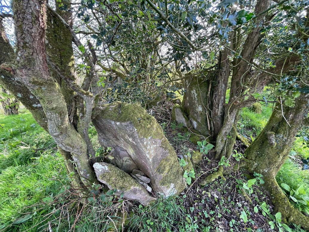
The scant remains here lie one and a half kilometres west of the centre of Omagh town. The deep spring green of the fertilised fields is almost off-putting. Ballyrenan is only 12 kilometres northwards so why bother? Nothing much is visible from the road and at first the layout of the SMR map has me confused, almost enough to give up. Then, oriented correctly, I leg it south, uphill and close to the field boundary.
The very box-like/cist-like remains, incorporated into the field bank, get inundated in the summer – now, in mid-April, it’s still difficult to see the southern part of the tomb, vicious, dry brambles from last year still tangling two of the orthostats. They say it’s the possible remains of a court tomb – various scattered stones could be this or that. I didn’t hang about much, Ballyrenan too much of a distraction.

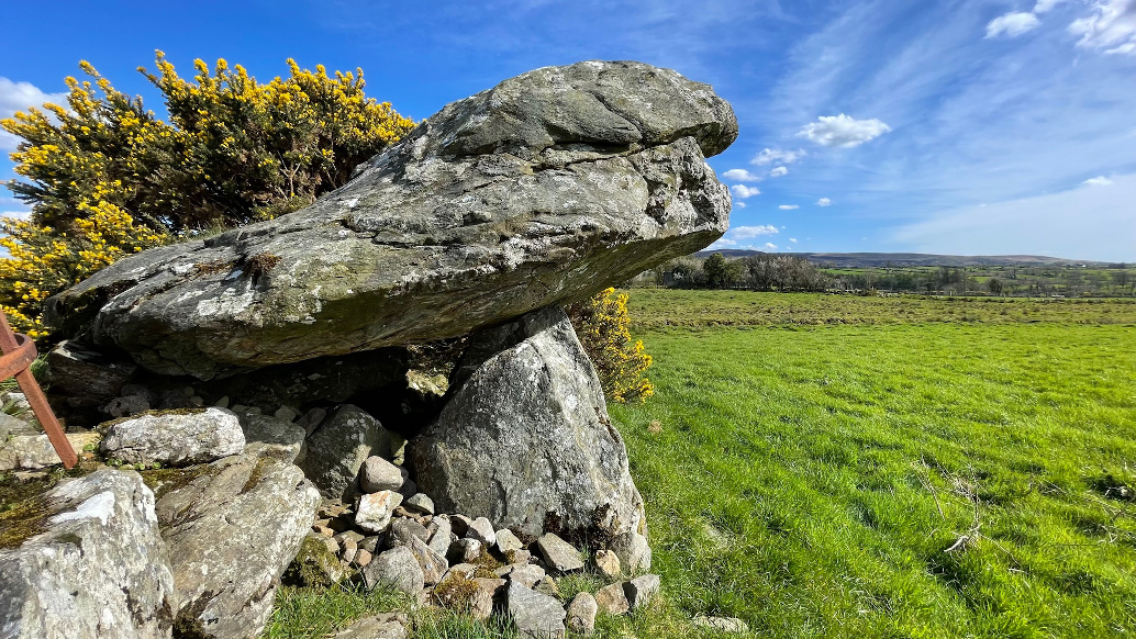
Two fairly well-matched portal stones, though you’d never tell with all the trees.


Looking west. The eastern sidestone and the capstone are missing.
Visited 27.04.22
There is a robbed out cairn on the summit of Cairnharrow. It is roughly circular, measuring c. 12m in diameter and 1.3m in height according to Canmore ID 90588 (go to Links). There is a modern stone cairn in the centre of Cairnharrow Cairn, presumably constructed from stones removed from the surface of the cairn. The dry stane dyke S of the cairn could also account for the destruction of the cairn. The resulting turf footprint is covered by rough grass with a circular depression in the N Arc.


Modern Cairn on Cairnharrow Summit Cairn viewed from N
The A505 runs between Omagh and Cookstown and is a fast and unforgiving road. It’s also littered with megaliths to its north and south. Heading west from An Creagán, we pulled up on the northern verge at the bottom of the field. I didn’t wonder who might have been interred in the tomb we were visiting. It was just another ruin, taken in on our way to better places, but revered nonetheless.
It’s tucked in under, and almost incorporated into, an ancient but later field boundary. It’s aligned east/west, with the front at the west. The map says megalith, the SMR court tomb. Any remains of the shallow court are difficult to discern – some of the stones here seem to be dumped field clearance, though the field is little more than a bog now, poorly drained. Mulderg rises to the north-west, scarred terribly with the gouges of quarrying. South-east is a long expanse of heather covered bog.
Most of the gallery sidestones remain, presuming there was only one chamber. A laterally placed stone on the southern side may be a segmenting jamb. There is no stone opposite it at the north so there’s no telling. Two matched stones further east and no closing stone at the rear leads to the conclusion that the rear of a second chamber may have been robbed. Two stones, one splayed out over the entrance stones and another thrown down in the ‘court’ may be roof stones or lintels.
I doubt this place ever fully dries out. It’s not a showy sort of place and is almost stranded there 200 metres from the road as the traffic flies past. I had no huge expectations and I can’t say I was either under- nor overwhelmed. It’s a small relic in an area with many more ‘important’ sites but might be worth your efforts, just bring some wellies.