Latest Posts

All posts 3,776-3,800 of 163,020 posts

May 26, 2025

Folklore

Scratchbury
Hillfort

Norton Bavant. ... The village lies at the foot of a remarkable old British encampment known as Scratchbury, one of the finest, largest, and best preserved of the many in this neighbourhood. Leading up the encampment is what is known as “The Nuns’ Path,” and it is stated that a nunnery formerly existed near Scratchbury, at a place called Middleton, which forms part of Norton Bavant Parish.

The Warminster Herald, 12th August 1882.

Folklore

Cotley Hill
Barrow / Cairn Cemetery

Heytesbury. Independent Sunday School. On Whit-Sunday the anniversary in connection with this school was held. [...] On Whit-Monday the children assembled at the schoolrooms in the morning, and from thence paraded the principal streets headed by the Heytesbury Amateur Fife and Drum Band. Divine service was held, after which they marched through the town again and then dispersed till the afternoon when they came to the schools and had plum cake and tea. Then they went on Cotley Hill, where hearty games was indulged in till dusk, when they sang a few hymns and separated, being highly pleased with the day’s outing.

Wiltshire Times, 22nd May 1880.

Congregational Sunday Schools. On Wednesday the scholars of these Sunday Schools had an outing to Cotley Hill, where various amusements were indulged in and refreshments provided. The Heytesbury Brass Band, under Mr. T. Cross’s leadership, was in attendance, and played a capital selection of music. The outing, it will be remembered, was postponed from Whit Monday, on account of the inclemency of the weather.

Warminster and Westbury Journal, 20th June 1885.

In addition to being a good spot for musical outings, twenty years earlier everyone ended up after the celebrations for the marriage of the Prince of Wales. There was a distribution of money from Lord Heytesbury, a parade with a fife and drum band, and the children were ‘bountifully regaled with tea, cake and oranges in the National School-room’.

There was also a bonfire on Cotley Hill (famed by antiquarians), near the large barrow which the Romans are supposed to have used as an exploring post. From this elevated spot, which commands a most extensive view, as many as twenty-four bonfires were seen lighting up the distant hills on the night of this joyous day.

Salisbury and Winchester Journal, 14th March 1863.

Folklore

Dun Uragaig
Promontory Fort

...It is interesting to find that a close connection existed between Colonsay and Oronsay and Dublin, in this way, that Aud or Audna, who was the Queen of Olaf the White, lived at Dun Uragaig on the north-west side of Colonsay, along with her son Thorstein the Red. Aud was known as the richest woman in the world, and later she proceeded out to Iceland, and founded a colony at Hvamm Firth. Aud is a very great personage indeed in the Icelandic Sagas. I would refer your inquirer to Grieve’s “Oronsay and Colonsay,” in 2 volumes...
From Mr W.H. Milligan, Carnlough.

A correspondent in the ‘Northern Whig’, 16th October 1924.

Image of Dun Uragaig (Promontory Fort) by Rhiannon

Dun Uragaig

Promontory Fort

Plan showing the hut circles inside, from ‘Field Work in Colonsay and Islay 1944-45’ by Stuart and C.M. Piggot, in Proceedings of the Society of Antiquaries of Scotland, vol 80 (1948).

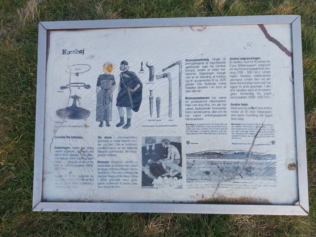
Korshøj

Artificial Mound

Korshøj is a Bronze Age burial mound in Svendborg, probably from the Bronze Age (1800-50 BC). The mound is notable for its unique location in the middle of a roundabout in Svendborg, where Højensvej, Lehnskovvej and Juulgårdsvej meet. The name “Korshøj” refers to this location in a crossroads that forms a cross. The mound has never been the subject of archaeological excavations.

The first official description of Korshøj dates from 1850, when the National Museum registered it.

The mound was protected in 1913. At the time of protection, the mound’s dimensions were stated as 3.9 meters in height and with cross-sections of 18 meters (E-W) and 21 meters (N-S). In 1983, the height was measured at 4.8 meters by the Danish Forest and Nature Agency, which described it as a monumental large mound with a distinctive location. The difference in height can possibly be explained by a lowering of the road around the mound in the 1950s.
On the north side of the mound, a stone staircase has been built, probably at the instigation of Egense Parish Municipality in the late 1940s or early 1950s.
These stairs were repaired by Svendborg Municipality in 2009.

Korshøj has historically served as a gathering place for the young people in the parish. In 1943, it caused a stir when students from the Gymnastikhøj School rode over the mound on their riding horses.
There has been some confusion with another nearby mound called Loddenhøj, which has however been ploughed down.
Korshøj is today registered with the Danish Agency for Palaces and Culture as a protected ancient monument with protection number 41171 and site and locality number 090504-19. The mound is thus a distinctive and protected element in the landscape near Svendborg.

Source:
kulturarv.dk/fundogfortidsminder/Lokalitet/8868/

Image of Milltown (Standing Stone / Menhir) by Intrepid Duke

Milltown

Standing Stone / Menhir

And just across the road from the millstone you’ll find this phallic beauty, surrounded by sheep and their lambs. Previously perhaps the site of fertility rituals, the standing stone’s fertility clearly still being potent, if the lambs are anything to go by.

May 25, 2025

Auchmull

I’d been meaning to visit the Auchmull cairn many times having gone past the site on numerous occasions.

As usual Mr Sheriff’s notes in Canmore don’t give much away, the four small cairns he mentions are at best field clearance cairns but more likely just to be dumped stones.

However, the main cairn remains despite some bad treatment. It still sits at over 12m wide. One kerb appears to remain in place with, perhaps, others scattered all over the place.

The winter weather makes the shape of the cairn easy to spot, it still reaches over 0.5m in height, thankfully no wintry showers at this point.

Nice way to start 2025.

Visited 04/01/2025

Dun Uragaig

The weather remained cloudy and the wind had picked up for the last visit to a prehistoric site on the this trip Colonsay. Follow the track as it heads south west from Dun Tealtaig. Uragaig is easy to spot with its distinctive shape.

Apart from the entrance on the east, a natural causeway some of which has collapsed, the rest of the fort is surrounded by steep cliffs and guarded by some sheep.

It seems to be a fort of extensions, nature had been kind to the builders providing them with what looks like spare rooms, to me at least. They also made use of the ridge on the east side and built a wall – 60m in length and survives, still standing at just over 0.5m and 2m wide. Inside this wall there are several hut circles and other traces of buildings, probably built at a later date.

So that was Colonsay, guess we’ll be back.

Visited 15/08/2024.