Latest Fieldnotes

Fieldnotes 3,826-3,850 of 19,536 fieldnotes

July 14, 2015

Collessie Farm

Collessie is a small village situated in the north east quadrant of the B937/A91 junction. We parked near the railway bridge and proceeded north thru a farm called The Steadings. After several fences we reached a field with the cairn in view.

On this day the field had young bullocks in it, very friendly I thought, not so friendly ALC and B thought. Still they spoke away to me and casually let the others (fearties) walk towards the gate near the cairn.

That the cairn survives is a miracle (its nearby more famous relative wasn’t so lucky) and its to the farmers credit that it is in pretty good condition.

It is a Wessex Bell cairn, the bottom platform is some 29 meters wide, almost 1.5 meters tall, the inner platform being 16 meters wide, and is also almost 1.5 meters tall. Hints of a ring of kerbs remain. Underneath the gorses signs of how the cairn was built can be seen. Elsewhere some field clearance can be found on the southern edge. Overall a very good and pleasing site.

Once again The Lomonds dominate the view with the conquered Glenduckie to the north. This time the walk back to the car was bullock free.

Visited 5/7/2015.

Norman’s Law

From Creich Manse keep heading west and pull in about a 1/2 mile west of Pittachope Farm. The walk is signposted so follow the gentle climb until a tee junction of tracks. Take the eastwards track which eventually swings south and leads to the middle of two hills, Black Craig (which looks like it should have a fort) to the east and Norman’s Law (which has a fort) to the west.

We followed a track heading west gradually climbing up the northern flank of Norman’s Law. This path vanishes into nothing and the climb becomes quite steep. Still the aim was to approach from below the trig on the north west and this was achieved. By going this way the forts northern defences can be seen. Basically follow the wall up and trig, hill indicator and climbers cairn come immediately into view.

The view from the top is wonderful, to the east is now part of Drewland, the west has the soon to be conquered Glenduckie and the south has The Lomonds.

Walls on the southern flanks are in good condition as is the front door to the east. The various hut circles have slight remains in the forts interior. Stunning place and obviously a place of importance.

Heading back down we followed the track thru the front door heading east towards Black Craig. Between the hills there is a crossroads, tracks to the two hills, the main track heading south which swings around Black Craig eventually heading back north, or as we (I?) decided the direct steep path heading north. Good fun it was as we stumbled back to the main track and the car.

Great walk, great climb (not to difficult), great place.

Visited 29/6/2015.

July 9, 2015

Dundee Law

Easy to find and a nice tarred road all the way to the top. Last time I was here it was covered in cyclists and spectators for the start of the Tour Of Britain. Today it was much quieter and a nice way to get some fresh air after a hectic day. It is the home to Dundee’s war memorial, various masts and a viewing point.

Not much remains, if anything, of the fort now except the view which is stunning. Fife, soon to be renamed, is to the south, heading west is the Tay valley, north is Angus/Aberdeenshire and to the east is the North Sea. Fantastic place to go hillfort/cairn spotting.

Visited 4/7/2015.

Westerheide 7

Visited: June 17, 2015

Westerheide Mound No 7
This is probably the largest of the burial mounds on the Westerheide.
After visiting Mound No 8, continue along Erfgooiersstraat for just a few metres till you come to a broad sandy path heading into the woods. Follow this till you have passed all the trees (for about 230 metres) then head to the right, taking the path that follows the tree line. The mound is obvious, just clear of the trees, another 300 metres on.

Westerheide 8 and 9

Visited: June 17, 2015

Westerheide Mound No 8
This is one of the larger burial mounds on the Westerheide, and the easiest to visit. Starting from Hilersum Media Park railway station, the easiest route follows Johannes Geradtsweg then up Jacob van Campenlaan till it intersects with Erfgooiersstraat. Turn left here, and you will see the Burial Mound just 100 metres farther on, in a woodland clearing on the right-hand side of the road. The distance to walk is just 1.9 kilometres each way, or you can take bus No 2 from Hilversum Main Railway Station.

In the map below, the pink markers indicate the two Grave Mounds. The No 2 bus stop is shown slightly right of centre at the foot of the map and the path into the Westerheide Reserve itself is drawn in yellow.

 
Westerheide Mound No 9
This slightly larger mound lies less then 20 metres to the northeast of No 8. Like its near twin, it is heavily vegetated with a mixture of broad-leaved plants and brambles. Both mounds are around 2½ to 3 metres tall.

July 8, 2015

Banks

Visited on July 6th, finding the site greatly altered since our first visit in 2012. The tomb has seen no great changes.......just a large and thick sheet of fibreglass forming part of the roof, and a iron grille with padlock for security purposes.
The Skerries Bistro is now housed in a large modern steel building at the “front” of the site with adjoining visitor centre. Carol now handles the indoor, hands-on part of the visit, with Hamish showing you around the tomb structure (between bailing out water from the floor!) They continue to resist attempts of a “takeover” and thoughts of a raised false roof. No desire currently to excavate further any of the chambers.
Both Carol & Hamish are very open about the very blinkered approach of the local authorities which has strengthened their desire to leave well alone for the moment. A visit now costs £6 and the bistro fayre is even better!

July 4, 2015

Kinbrace Hill

Ha! What new sorcery is this? Surely even a myopic Citizen Cairn’d such as I couldn’t have ‘overlooked’ monuments of this magnitude during my previous visits to the Strath of Kildonan, lamentably few though those have been. Surely not? Luckily, not least for the preservation of any lingering notion of personal sanity there is a pretty straightforward reason for the oversight, this given immediate credence by the carnage of devastated timber covering the hillside. Yeah, concealing something in plain sight would be a pretty Machiavellian concept if premeditated; needless to say conspiracy theorists need not linger. Forestry comes and goes in these parts.

Moving on from the arresting Creag Nan Caorach – itself a sequel to the excellent Carn Richard – it becomes apparent that there are simply an overwhelming number of sites lining the flanks of this valley. A linear progression requiring at least 48 hours. Clearly my itinerary is (once again) shot to pieces and I will have to stay another day. Hey, shame it’s not Christmas since that reminds me of a certain song. With bells on. Anyway... suddenly a massive circular stone pile looms above the road to my left. I check the map – in confusion since I should not be able to see the cairn for the trees – and, to be honest, don’t know where I am. Whatever. It’s not as if it’s the first time....

The cairn (NC86882935) appears circular, of impressive stature and apparently ‘unopened’. It is almost certainly chambered, two uprights upon the approx south-eastern arc surely representing the entrance to a passage, albeit one now inaccessible? Audrey Henshall [1963] reckoned the monument measures “87ft E-W by 83ft, and the height at least 9ft”. What a fine, unexpected way to end the day. But wait, there’s more. Much more. And it’s even more special.... iconic, even.

A further mass of grey stone visible crowning the rise of the hillside to the approx south-east sees me stumbling, with great difficulty – and I have to say many expletives – across the chaotic residual detritus of those forestry operations in order to take a look. It is worth the effort (a bit of an understatement, that), the apparently damaged profile revealed to be formed of two distinct, very large cairns as I draw near. That to the north-east is the higher of the two and (apparently) the earlier, by all accounts seemingly another, even more massive round cairn. However the sheer scale ensures first appearances are most certainly deceptive for (once again according to Audrey Henshall) it is actually “almost square with rounded corners and rises steeply to a height of 14ft.... about 100ft along its main axis”. Furthermore it possesses “a low horn projecting about 7ft on the north”. OK.... not your standard cairn, then? Very idiosyncratic indeed. Its companion, set immediately to the south-west, is similarly unusual. Somewhat lower at “10ft high” its horizontal dimensions (at least in 1963) are “102ft long, 62ft wide at the SW end and 36ft wide at the NE end”. Make of that what you will?

Blimey. So what the hell was all this about, then? Just what was going on in the minds of those people who toiled to erect these monuments millennia ago? Was this a long cairn subsequently ‘decapitated’ by separating the north-eastern head from the body. Or were these two cairns always set apart, albeit associated. A prototype for the genre of monument that would, by combining the two, eventually become the ‘long cairn’? Perhaps Kinbrace Hill’s outstanding monuments are analogic of Caithness’s celebrated Grey Cairns of Camster? Only far, far more obscure, at least nowadays? The mind boggles to find such extraordinary stone piles still standing here, apparently intact. Truly, it does.

I return to the chambered cairn near the A897. All is quiet.... there is no traffic... and watch the light slowly fade to dusk following a last brilliant sunburst, the final hurrah of a previously subdued sun now illuminating the landscape with a golden glow. A metaphorical brass fanfare to what I’ve just witnessed, perhaps? Marvellous. Now for somewhere to sleep.

West Mains of Ethie

Visited: July 2, 2015

This site lies on the clifftop, 300 metres due south of West Mains farm, and was the first one I visited during my ‘expedition’ to Prail Castle, farther north. Discovered in 1961, West Mains Of Ethie promontory fort was found to have been defended by triple banks and ditches across the base of the headland, broken by a centrally placed entrance which was approached by a causeway. There is an excellent aerial photograph of the promontory on the RCAHMS website.

There is more to read about excavations at West Mains of Ethie on the Canmore website.

Red Head

Visited: July 2, 2015

Red Head, only discovered as recently as 1961, is the northernmost of the six promontory forts ranged along the Angus coastline, and lies about a kilometre north of Prail Castle. Perched above 81 metre tall cliffs, Red Head fort lies at the highest location on the Angus coast.

Evidence was found of a rampart, ditch and causeway, but the site was badly mutilated by trenching associated with its use as a World War I observation post.

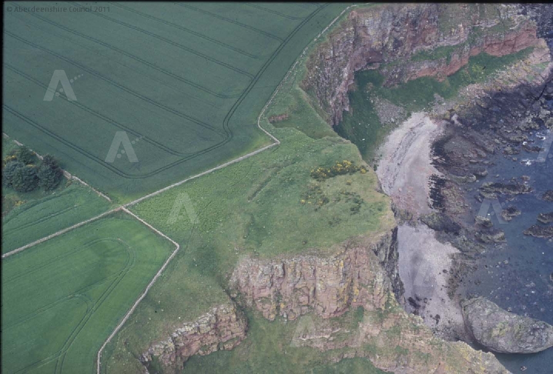
There is an excellent aerial Photograph of Red Head on Aberdeenshire Council’s website.

You can read more about this site on the Canmore website.

July 3, 2015

Prail Castle

Visited: July 2, 2015

One of the six iron-age forts that bedeck the Angus coastline, Prail Castle sits on a long promontory located about 3½ kilometres walk south from Lunan Bay, and not far from West Mains farm. There is an interesting aerial photograph of it on the Canmore website.

I chose to approach Prail Castle from Rumness Point (i.e. from the south) which, in retrospect was probably a mistake. Although the distance was only about 1½ kilometres, it took me all of two hours to attain my goal. There was no path, vegetation was rank, and the neighbouring field of mature oilseed rape was impenetrable. The easiest option was to stick close to the well-built sandstone drystane dyke that marches round the cliff edge.

Not knowing quite what to look for, I ended up at Red Head, a kilometre north of Prail Castle. You might think that a promontory all of 150 metres in length jutting out to sea would be hard to miss. But it isn’t. For most of the approach walk, thick gorse obscures a direct view of much of the coastal scenery and, at the point where I came level with Prail Castle, a grass-covered defensive rampart completely obscured the promontory from sight. So I simply pressed on.

Finally, as I started to return from Red Head, all was revealed. Views from the north were expansive and Prail Castle became an easy target. According to Canmore, ‘the ditch, rampart and the foundation of the tower and other buildings are visible‘. Not, alas, in July with knee-high vegetation clothing the site. A visit early in the year would surely prove more revealing.

July 1, 2015

Dun Chaich

Visited: May 29, 2015

This robbed dun lies on a steep rocky ridge, Cnoc a’Chrochadair, on the spine of the Uiginish peninsula, about a kilometre west of Dunvegan, on Skye. The location is impressive and would have been a fine vantage point, but today there is little to see of the dun apart from stretches of foundation course.

Access to Dùn Chaich is from the same starting point as for Dùn Totaig. But this time, turn left where the path branches just north of the field, and follow a pleasant, wide grassy path for about 400 metres till you meet the first gate. Now head left, uphill to the conspicuous dip in the ridge, and work your way up to the summit of the crag on the right. It’s probably best to contour round the easier slopes to the north and approach from the northeast.

Dun Totaig

Visited: May 29, 2015

Excavated by Countess Latour, who was the first to excavate brochs on the Isle of Skye—Dùn Fhiadhart in 1892 and Dùn Beag in 1914—Dùn Totaig is now largely a mass of tumbled stones, particularly in the interior. Nonetheless, some structure does remain: a good section of foundation course in the south and a neatly built section of entrance passage in the north.

The Dùn lies less than a kilometre from Uiginish House, from where a good farm track leads southwest from beside a large barn.

One problem I faced came where the initially straight path bore left as it started to circle round the foot of Beinn a’Ghuail, a low (57 metre) gorse-clad hill. The path became increasingly muddy, and after 100 metres or so the mud was over the top of my boots.

So I climbed the fence into the field on the left, which provided good walking to the Dùn. There is in fact a gate into this field at the point where the path forks (the left branch heading southeast towards Dùn Chaich). Provided there is no livestock grazing, this would have been the best mode of approach.

June 29, 2015

Garnedd Uchaf

There is no easy way to get here, there can be no drive by action photo, not even a leisurely sunny picnic, you cant even, if you get there, point at the ancient site and say there it is. This is about as far from civilisation as you can get in Wales, but it is not off the beaten track, it is right on it, it is not far from the maddening crowd, you’d think it would be, until 40 odd runners jog by.
My walk started in the full car park at Bwlch y Dduefaen, after a quick shufty round Barclodiad Y Gawres, and the standing stones it was follow the old grey wall up the hill. After much turning round and staring off wistfully into the distance I got up on top of the first summit, Carnedd y Ddelw, it has a very good cairn. Then up to Carnedd Penyborth-Goch on top of Drum, it too, as the name suggests is a cairn, it’s not quite as good as the last one but it occupies a superior position.
The plan was get up Llwytmor mountain, but as my memories fade into soft middle age I realise that I cant get to Llwytmor without going up Foel Fras. So I just go up there, and decide to see what is what when I get there.
The incredible landscape up on Foel Fras should have been enough to keep me seated here until it was time to go, but a couple of race marshals are just a few meters away and the runners are passing by closely, did I mention there is some kind of cross country race going on, these fruit cakes are actually trying to run up a mountain, they fail quite entertainingly, it does me good to see people more knackered than me, one plonker had his shirt off and asked me for sun cream, your kidding right, expose my skin to the angry sun?. I watched them pass me by and wondered how you would go about getting up a mountain quickly, apparently you bend over double, grab your knees and push, wringing every last drop of energy from those poor abused legs.
Like I said, this new to me summit should have been enough, but the newly laid path isn’t too steep up to the next summit, which looks like it’s got a killer view of Yr Elen and if i’m not mistaken is Garnedd Uchaf, I absolutely refuse to call it by that new fangled name, what ever it is.
So I gird my loins, I lied there sorry, I don’t even know what girding is, and head off for what surely must be my final destination.

Coflein says very little about the summit of Garnedd Uchaf, it only assumes there was a cairn here because of the mountains name, Carnedd is a cairn. But it also, just to add to the TMA’ers confusion, says there are some piles of stones that delineate the county border, it was I think one of these that I’ve photographed and put up on here.
There may well be a ruined cairn up here somewhere, but there is so much stone up here that you could probably point at ten collections of stone and say is that it? or maybe none at all. There is enough stone up here to build half a dozen Castleriggs and still have enough left over for a Long Meg or two. Perhaps the most conspicuous of prominent rocks up here is what earned this peak the name of Carnedd, it certainly looked like a big cairn from Foel Fras. I take a seat among these highest rocks as much out of the wind as possible which is not at all because it’s coming from the direction I want to face. The direction you want, no, the only way to look is southish, the view is stunning, possibly the best view in Wales, shoot, I may have said that before. Immediate and centre is yr Elen, to it’s left is Foel Grach, Carnedds Llewelyn and Dafydd, to it’s right Carnedd y Filiast, Elidir Fawr and maybe Y Garn, and many more as the saying goes. With no cairn to inspect there is much time to admire the view, and it is admirable. But mountain watching, brilliant as it is, always has an end and I’m reaching my end of the day, the good thing about the route I’ve taken is I get to see the whole thing again, all four or five miles of it.
By the time I get back to the car my feet aren’t just sore, they’re positively throbbing, and the battery in my camera died too soon, and I didn’t have anyone to say “hey, that looks good doesn’t it” to, I felt a bit guilty not having Alken with me, I know he’d have loved it.

June 28, 2015

Westerheide

The Westerheide, which lies to the immediate northeast of the city of Hilversum, is part of het Gooi Nature Reserve, where some 17 burial mounds can be found. Significant archaeological finds have been made here, some of the earliest around 1855 by Albertus Perk, who examined the mounds, and discovered to his surprise 32 urns. In addition to many pottery shards, Perk also found a pair of bronze bracelets, a fragment of a spiral finger ring and a bronze pin.

To visit on foot, start from Hilersum Media Park railway station. The easiest route follows Johannes Geradtsweg then up Jacob van Campenlaan till it intersects with Erfgooiersstraat (blue marker). Turn left here, and you will see Burial Mounds 8 and 9 just 100 metres farther on, in a woodland clearing at the right-hand side of the road (pink marker). The distance to walk is just 1.9 kilometres each way. The main entrance to the Nature reserve lies a further 40 metres along the road (green marker).

Alternatively, if you start from the main Hilversum railway station, you can take bus No 2 to the Hendrik Smitstraat halt (on the corner with Erfgooierstraat – blue marker). Again, just turn left at the junction, and you will find Burial Mounds 8 and 9 just 100 metres farther on (pink marker).

staticmap?center=52.2392,5.179&markers=size:mid|color:red|52.2424,5.1840&markers=size:mid|color:blue|52.2417,5.185&markers=size:mid|color:green|52.24233,5.18326&path=color:0xffff00ff|weight:2|52.23746,5.17374|52.23457,5.17627|52.23583,5.18683|52.24169,5.18494|52.24211,5.18374&zoom=15&maptype=hybrid&size=580x400&sensor=false&key=AIzaSyCp6JckL_ykPLQNTeiT2zJYsaR9v2NDwpk

To visit all the mounds involves a walk of no more than 5 kilometres, and takes just an hour and a half.

The locations of 13 Grave Mounds on the Westerheide are shown on these maps on the website of Museum ‘Oer‘, located in Ulft, Netherlands.

The information board beside Burial Mound No 2 states:

The heaths around Hilversum are rich in archaeological monuments. Urnfields, burial mounds and traces of ancient settlements have been identified in various places. The Westerheide has archaeological monuments like this mound, which were raised to bury the dead, often with multiple interments. The burial mounds date from 2900 – 1100 BCE, the so-called Late Neolithic and Middle Bronze Age.

The burial mounds tell us about the prehistory and human life of the time. This information is irreplaceable, and for this reason it is written into Law that such objects should not be disrupted or altered. Setting foot on them – resulting in erosion and wear and tear – is such a threat.

To counter this, the Gooische Nature Foundation collaborates closely with the Archaeological Monumentwacht to look after the reserve and preserve its cultural history.

Fincastle Farm

26/06/2015 – I wasn’t that keen on this one. I think my mood was a little low from the rain so I didn’t give it a fair chance. The location felt a bit odd, not farmland and not really hillside. Heading back over the rise to Strathgarry there was some nice limestone to look at which cheered me up a little.

Dundavie

26/06/2015 – Cairn marked on OS map. Not much to see. Small cist just showing through the heather. If you want to get someone interested in prehistory I’d maybe pick elsewhere for their first site :-)

Strathgarry

26/06/2015 – Parking area at Balrobbie Farm. Good access onto the hillside (steepish path). We then headed west past Ardtulichan, some lovely cup marked rocks round here. The path marked on the OS map takes you pretty close to the 4 poster. Nice site with great views. Weather by this point was rubbish so we thought we can’t get any wetter so decided to walk on over the rise to have a look at the standing stones on the other side. A soggy but fun(ish) walk.

Ardtulichan

26/06/2015 – I liked this one. Thanks to George and others for making my soggy walk to Strathgarry 4 poster a bit more interesting :-))

Lettoch

26/06/2015 – Possible cup marked rock (NN 91061 64289) above Lettoch. Rock is about 100m to the south and downhill from a hut circle (?) (NN 91065 64401). If you are passing I would be interested in another opinion :-)
Fine area for a walk.

June 27, 2015

Strathgroy

21/06/2015 – After a visit to Glen Clune cairn, a short walk north of here, we had a look for this cairn. Canmore has entries for two different cairns very close to each other, Sithean Na Cluana and Strathgroy. I had a look about for a second cairn but I think both entries refer to the same cairn. This ‘fairy knoll’ is great. Fantastic location overlooking the River Garry. We did have a close encounter with some cows on the way which involved a stand off, a little bit of fast walking, a  brief moment of jogging and quick jump over a wall. As luck would have it we ended up in the correct field. There were cows in this one but these were a bit more laid back. Still we didn’t push our luck so the visit to the cairn was short. Well worth a visit just for the vibe and views.

Dry Tree Menhir

Visited 26th June 2015

After leaving Halliggye fogou it seemed rude not to visit the Dry Tree menhir as it was only a couple a miles away and so seemed a fitting way to finish off the day even though we didn’t really know what to expect.

I made the mistake though of first taking the turning into the Goonhilly Earth Station, and on arriving into the eerily deserted parking area it became apparent we were probably in the wrong place. I got out of the car for a scout around but was unable to spot anything vaguely megalithic. The area had a strange feel to it, the giant dishes of the listening station looming mute above the perimeter fences and with no visible signs of life inside the compound, it felt like the sort of place the survivors of a post-apocalyptic alien invasion film would end up at.

Getting back into the car we were almost ready to give up and come back another day, but fortunately we had a signal on the phone (would have been somewhat ironic if there had been no reception here of all places!) and a quick check of the internet suggested that we actually needed to park at the old RAF site next door.

So back down the B3293 and in minutes a brown sign indicating ‘National Nature Reserve’ pointed us into a turning which leads to a sizable parking area. Here several paths lead out over the downs, and information boards and some very good leaflets are handily available to guide the way.

Following the path which shadows the perimeter fence we soon see the stone ahead of us, and it’s much taller than I expected. From the angle we approach it reminds me a friendly giant with a tiny head perched atop his wide body. As I happily wander around the menhir taking photos from every conceivable angle I’m struck by the way the stone has such a different appearance from each side you view it from.

This is a lovely stone, I was a bit worried that close proximity to the perimeter fence might spoil the ambiance somewhat but the counterpoint of the modern dishes with this lovely stone just sort of works. I’d love to explore some more of the walks across Goonhilly, perhaps spotting some of the many barrows around which dot the landscape, but that will have to be for another time, only Cruc Draenoc barrow will be close enough for a visit today as I can see that one from the stone!

It’s nigh on 8pm now as we bid farewell to the stone, and hunger pulls us away home for supper. As we walk back we’re escorted by Meadow Brown butterflies that flutter along the path in front of us, a magical end to a lovely visit.

Glen Clune

21/06/2015 – Sometimes two stones are enough. It might not look much but I was really taken with this cairn. Location is great with fine views all round. Easy access from a few starting points. We combined it with a walk over Meall Mor, starting from Lettoch. A peaceful place.

Goonhilly Down

Visited 26th June 2015

Cruc Draenoc is one of many barrows which dot the landscape around Goonhilly Downs, but this one benefits by its close proximity and intervisibility with the Dry Tree menhir.

From that stone the unmistakable lump of the barrow looms to the south west, easily distinguished by the trig point and concrete post which crown it.

We poke about the barrow, the late evening sun still blazing down on us. The mound itself is quite low, but it stands on the highest point of the downs, and the view out and down to the sea is wonderful. It’s difficult to discern the exact size and shape of the barrow due to the ferns which mask its outline, but it’s mercifully free of the thorny gorse which covers much of the downs, and no longer lives up to its old Cornish name, Cruc Draenoc, which means ‘barrow of the thorns’.

It’s a strangely beautiful landscape here, and a nice bonus to stumble across a barrow of this size at the end of a pleasant walk.

D23 Bronneger

Visited: June 18, 2015

Hunebed D23, measuring 6.0 × 2.7 metres, originally consisted of four capstones supported on eight sidestones. But the years have taken their toll, and only a single capstone now remains. It is unknown if there was ever an entrance portal or circle of kerbstones around the hunebed.

Nevertheless, this hunebed strikes a remarkable ‘dolmenesque’ profile that instantly captures the eye, its single flat capstone perched proudly on its twin orthostats in near classic pose.

----------------------------------------------------------------------------------
NOTE
All the photographs provided for this hunebed, apart from mine (i.e. prior to 2015), are in fact showing hunebed D24. It seems that many visitors assume that D23, D24 and D25 are arranged sequentially as they walk through the woodland.

But this is not the case. Precedence in numbering hunebedden runs from North to South. So the middle hunebed of the three (this one), being the most northerly, is numbered D23, The other two are then numbered in sequence from west to east.
----------------------------------------------------------------------------------