Elevation and plan of Pawton Quoit by Nicholas Whitley, from the back pages (opp p88) of the Twenty Second Annual Report of the Royal Institution of Cornwall, 1840.
Image credit: Royal Institution of Cornwall
Elevation and plan of Pawton Quoit by Nicholas Whitley, from the back pages (opp p88) of the Twenty Second Annual Report of the Royal Institution of Cornwall, 1840.

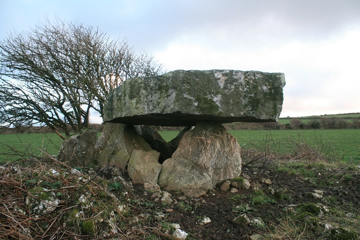
Pawton Quoit (also known locally as the Giant’s Quoit) dolmen on the edge of St Breock Downs is thought to have the heaviest capstone (14.4 tonnes) of any in Cornwall. The capstone is now broken in two, but was once 4.6m long.

Pawton Quoit (also known locally as the Giant’s Quoit) dolmen on the edge of St Breock Downs is thought to have the heaviest capstone (14.4 tonnes) of any in Cornwall. The capstone is now broken in two, but was once 4.6m long.

Pawton Quoit (also known locally as the Giant’s Quoit) dolmen on the edge of St Breock Downs is thought to have the heaviest capstone (14.4 tonnes) of any in Cornwall. The capstone is now broken in two, but was once 4.6m long.

Pawton Quoit (also known locally as the Giant’s Quoit) dolmen on the edge of St Breock Downs is thought to have the heaviest capstone (14.4 tonnes) of any in Cornwall. The capstone is now broken in two, but was once 4.6m long.

From William Copeland Borlase’s ‘Naenia Cornubiae’ (1879).
archive.org/stream/naeniacornubiaed00borluoft#page/277/mode/1up


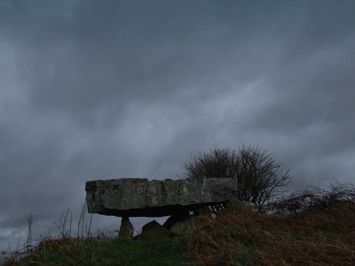

Looking across the arrow-shaped capstone, following the the line to the gap in the distant hills, showing the sea.

Approached from below, this was quite difficult to see from a distance due to the overgrown foliage.

Look at the size of that capstone! How does that front stone NOT collapse under the weight?


Sept 1983

Sept 1983
Yaaaay! somewhere else I haven’t been before.
The list gets smaller still.
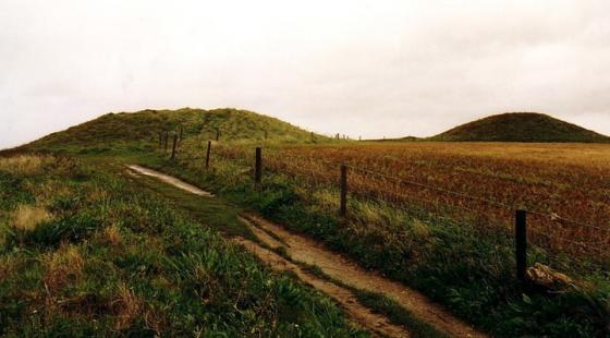
Probably one of the lesser known of Cornwall’s quoits. The Lands end quoits are a bit holidayish, but even though its only four and nine miles from Padstow and Newquay respectively, Pawton quoit takes a bit of finding, there’s not very good access either, and in the summer the ferns get high. All in all making it a bit lesser known than others.
I parked in the space before a little used gate at the north east corner of the chamber’s field, left the kids in the car and walked back up the road to where a scramble place has been carved over the field wall, deftly jumping over it I entered the field of choice and jogged over. Time was short and the sun was going down upon a long day that still had a nearly three hundred mile drive to finish with.
Since I first put this site on my list more pictures have been added on here, but none of them show how big the mound is on which the quoit sits. Even without the stone chamber I would still have made a special visit just to see the barrow if it were closer to home, it’s really quite large.
But then I didn’t get many of it either, just a couple with the sun going down behind it, and then just time enough to walk all the way round it hand draped affectionately across the stones. A gander underneath the whopper capstone, then came the car beeps.
Time for a couple of minutes inspecting the quartz veins running through it, a theme for the day, and looking round the vista the capstone points to, then another beep.
Damn! it’s time to go.
You will need a map to find this beast...or some friendly locals. I had both. After driving up the lane to the farmhouse at the top I turned around and asked the owners where the quoit was and where I could park. They advised me to drive back down the land and park at the first gateway on the left. The field in which the quoit stands is not theirs, so they said they could not give me permission to go in...but as the gate was open and there was only grass growing I went for it.
It is quite a long walk from the bottom corner to the quoit which is at the top of the field. It is also quite muddy..in fact the quoit has a shallow moat around it at the moment.
With all the brambles and whatever else died down it is easy to make out the surrounding mound, made up of quartz stones. Being that this is the common rock around here...is the whole pile made out of them? Are they only on the top? or have they been thrown there by farmers clearing the field over the ages?
The Quoit is not tall by the standards of others in Cornwall but it is the great thick capstone that makes it standout...such a shame that it is in a field with views of a huge modern farm just to the west...somewhat spoils the setting......I would think on a sunny day in times long ago this would have been a fantastic place to be buried.
Mrs Goffik and I were extremely lucky to have seein this on the last day of our trip in September.
It’s a cracking example of a quoit – the arrow-shaped capstone (which needs no introduction as it’s well documented) is HUGE!!! I know our ancestors were nifty with the old stone erection, but still... HOW???!?!
This place feels quite isolated, in a nice way. It’s difficult to see from below as it was covered in ferns and brambles when we visited (no crops, luckily for us!) but it commands some nice views.
And has anyone else noticed how it appears to point towards a gap in the distant hills that reveals the sea? Or is it just me? See themodernantiquarian.com/post/54132
After looking at the map, I’m now curious to explore what is marked, between the quoit and Men Gurta, as “Pawton Springs”. :o)
Access: From Wadebridge, follow the A39 South past the Cornwall showground, and take the left turn at Whitecross – signposted, as I recall, to Pawton and Nanscow(e). Follow the road for just under a mile and bear left at the junction. Take the next right (this heads toward the wind farm). The quoit is in, I think, the 3rd field on the right at the top end. There are several gates in the hedge along the road which are traversable. Parking is difficult, but once in the field, the going is quite easy.
Just make for Pawton farm, go to the farm, turn round and go back about 400mtr to field gate,you can just pull in here. From the gate look left and you can see the Quoit at the top of the field. The Burrow over this must have been very large, the remains are around the Quoit.
Sometimes known as the Giant’s Quoit.
Same type as the Trevethey Quoit but not as tall.
The capstone is a giant stone 15 feet long and 2 and a half feet thick.
It is estimated that thestone weighs about 14 tons making it the heavist of any standing Quoit in Cornwall.