The Modern Antiquarian
Log in
|
Register
Home
Latest Posts
Forums
Maps
Help
Browse Sites
News
Blog
Contributors
The Books
Select
-
Belgium
Denmark
Eire
France
Germany
Greece
Italy
The Netherlands
Norway
Portugal
Republic of Malta
Spain
Sweden
Switzerland
United Kingdom
County Cork
Lisnagun
Standing Stones
Lisnagun (Darrary) (Standing Stones) on The Modern Antiquarian, the UK & Ireland's most popular megalithic community website. 6 images, 1 fieldnote, plus information on many more ancient sites nearby and across the UK & Ireland.
Image © Charles Coughlan
Also known as:
Darrary
OS Ref (IE):
Latitude:
51° 37' 35.72" N
Longitude:
8° 50' 30.7" W
Added by
bogman
Images (6)
Fieldnotes (1)
0 discussions
Start a topic
Show |
Hide
Web searches for Lisnagun
Flickr
Google
Google Images
Bing
Stone Pages
Wikipedia
Show map
(inline Google Map)
- Sites within 20 km -
-
Darrary (0.02km NW) (4 posts)
Templebryan (3.34km W) (23 posts)
Templebryan (3.61km W) (0 posts)
Barryshall (4.66km ENE) (7 posts)
Cashelisky (6.84km W) (9 posts)
Burrane (6.85km NE) (4 posts)
Letter (site E) (7.16km W) (11 posts)
Ballyvackey (7.32km W) (30 posts)
Coorleigh South (7.32km WSW) (9 posts)
Ahaghilla (8.45km W) (13 posts)
Knocks (East) (9.58km WNW) (7 posts)
Knockatlowig (9.87km W) (10 posts)
Ahidelake (10.08km S) (3 posts)
Derryduff (10.63km WSW) (4 posts)
Knocks (11.66km W) (13 posts)
Knocks S (11.72km W) (18 posts)
Coolnaconarty (11.81km W) (9 posts)
Bohonagh (11.99km WSW) (45 posts)
Caherkirky (12.15km W) (11 posts)
Knocks (12.22km W) (2 posts)
Ahaglaslin (12.3km WSW) (3 posts)
Knocks N (12.32km W) (20 posts)
Burgatia (12.74km WSW) (5 posts)
Tinneel (12.8km WSW) (8 posts)
Inchinattin (12.82km W) (2 posts)
Galley Head (13.1km SW) (3 posts)
Freahanes (13.19km WSW) (7 posts)
Sarue (13.19km W) (7 posts)
Rosscarbery (13.46km WSW) (4 posts)
Corravreeda (14.22km NE) (6 posts)
Glanbrack (14.69km W) (15 posts)
Milleennagun (14.91km W) (3 posts)
Knockawaddra E (14.99km W) (15 posts)
Milleennagun (15.02km W) (12 posts)
Reanascreena (15.18km WSW) (46 posts)
Knockawaddra W (15.18km W) (17 posts)
Curraheen (15.49km WSW) (3 posts)
Maulatanavally (15.5km W) (26 posts)
Maulatanvally (15.81km W) (8 posts)
Carrigagrenane NE (15.84km W) (7 posts)
Parkaghadallaun (15.88km NE) (3 posts)
Lettergorman (North) (15.9km W) (25 posts)
Killaneer (16.18km NNW) (3 posts)
Carrigagrenane SW (16.29km W) (9 posts)
Laravoolta 1 (16.71km NW) (2 posts)
Lettergorman (South) (16.82km WSW) (39 posts)
Laravoolta 2 (16.83km NW) (3 posts)
Kinneigh (17.5km WNW) (5 posts)
Tullig Stone (17.58km WSW) (3 posts)
Drombeg (18.21km WSW) (70 posts)
Kinneigh (18.76km WNW) (4 posts)
Toom (18.78km WNW) (4 posts)
Bengour West (18.79km NNW) (6 posts)
Killacoosane (18.95km WSW) (6 posts)
Nedinagh West (19.04km W) (3 posts)
Ballyhalwick (19.36km W) (3 posts)
Ballyroe (19.39km WSW) (8 posts)
Garrygalss (19.62km W) (0 posts)
Garryglass (19.64km W) (3 posts)
- Add -
-
Add news
Add an image
Add fieldnotes
Add folklore
Add miscellaneous
Add a link
-
Add a site
Add a nearby facility
Add an alternative name/spelling
Images
(click to view fullsize)
Add an image
Fieldnotes
Add fieldnotes
Visited on the 29th January 2012
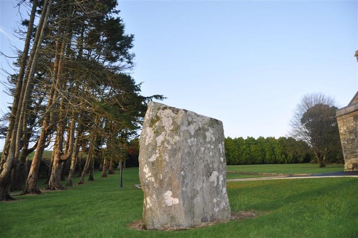
Situated in the grounds of the catholic church at Darrary, just past the Agricultural College and the reconstructed Ring Fort at Luis na gCon (Lisnagun) at W417418.
Comments (0)
|
Add a comment
|
Permalink
Posted by
Meic
29th January 2012ce