Dun Carloway Broch
23/7/94
A spectacular setting! This broch is perched high above Loch an Duin with views over to the sea to Bernera. One of the best preserved brochs in the Western Isles the back wall stills stands about 10 m high with a wall almost 4 m thick! There’s a guard cell by the door and there’s some neat steps up inside the wall from this cell. An inspiring view and great place to stop on the road to Callanish.
Martin

Diplomatically described here as a ‘Stone Setting’.
An OS report from 1980 suggest that this site may be a defended homestead which was adopted from a megalithic structure. This report also states that the evidence for a cairn is dubious.
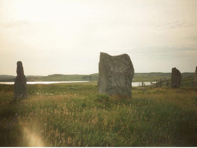
Steinacleit (AKA Lower Siadar) Stone Circle and Cairn
22/7/94
From our great wee campsite at Siabost, we headed north east today up the A857 on our way to the Butt of Lewis, stopping of first at the massive Clach an Trushal, then this site. This is a very complex place- there are only about 5 upright stones, but loads of others and the remains of a (supposedly) chambered cairn in the centre of the circle. I dunno- it’s a rather sad and disappointing place- I was mebbe hoping for a more grand stone circle- now it just looks very messy.


This stone was only rediscovered in 1903 buried at a depth of 8 foot (!) a few feet from the main stem of the yew tree- it’s now set up about 25 foot from its original site and has nine cup marks on its upper surface.
Fortingall Churchyard Cup Marked Standing Stone
First visited this stone in 1982 after reading about it in a small guidebook to the church. My obsession with the nearby Fortingall stones brought me here on many occasions, but this stone seems to be forgotten about when mention is made of the Fortingall sites. I know this is sacrilege, but to all intents and purposes it looks like some sort of megalithic bird bath ;) This (along with two of the stones of the nearby Carse Farm I four-poster) is one of the few stones which I have seen that has cup markings on its flat-ish horizontal upper face. This got me thinking about sky maps. The stone is behind the famous yew tree in the corner of the Currie private burial ground. When visiting check out the yew tree, the Fortingall stones and the church with its ancient bells and Celtic carved stones- a veritable antiquarian feast!
Carse Farm II
Burl lists this site as a four-poster, but only one of the stones still stands, two other (now recumbent) stones lie in an arc. An OS report from 1975 states that this site is definitely the remains of a large stone circle.
Carse Farm I Four Poster (AKA Dull)
Sometime in 1981...
This site (along with Croftmoraig and Fortingall) was one of the first circles I ever visited and one of the first places that really got me started on this megalithic journey that I am still on almost 19 years later. My folks bought a caravan near here back in 81 and I must have passed this site loads of times on journeys around Perthshire. I clearly remember my face pressed to the car window watching the four stones whiz past each time we drove along the B846. I managed to get my (tolerant) folks to stop off here a couple of times (bad mistake- I then got them to drive me to Fortingall, Croftmoraig, Lundin, Dunfallandy etc etc!) so I could get in amongst the stones. The site is small, squat and compact- still one of my favourite four posters. One of the strange things about it is the cup markings on the two eastern-most stones- they are on the flat horizontal surface facing the sky above (also check out Fortingall Churchyard standing stone). These two sites were also the first to trigger something in my mind and start an obsession with cup and ring marks and their magick and meanings.

Mention of the finding of the site in 1991
This stone was re-erected in 1889 with the smaller stone fixed to the top at that date. About 1830 the stone is said to have been brought down from higher up the hill because visitors to it were damaging the surrounding crops. It has been suggested that the name ‘Final’s Grave’ should apply to the original site and ‘Fingal’s Stone’ to the stone in its present position.
Fingal’s Stone (AKA Final’s Grave)
July 1995
This stone is to be found in the field just behind the school house in Killin. This small stone (less than 1 m high) looks like it has been pieced together from about three different stones! It’s a small triangular block and you can clearly see a join near the top where apparently a smaller stone was fixed to it- was it just too small originally?!
The stone is reported to have been found on the hill above the old parish church at NT2452 6303. Apparently there was said to have been a second cup and ring marked stone at the old parish church, but this is now lost.
Glencorse Cup and Ring Marked Stone
Visited twice- first time in winter 1993. This red sandstone slab lies next to the church tower of Glencorse Parish Church. The boulder has about 26 cupmarks, 10 of which are cup and ring.
Directions
Take the A702 Biggar road south out of Edinburgh and pass both Boghall and Easet Howgate farms. Take the next road left just about opposite the track up to Castlelaw souterrain. Follow the winding (and steep) road down towards Milton Bridge, the church being round the corner at Milton Bank before the road joins the A701.
Crichton Mains Souterrain
Winter 1990
I first found out about this place after one of my mates had sold his camper van to a guy who was into battle re-enactments and who had a local historical knowledge. So- on one of our mad Sunday afternoon outings we all piled out here. We knew it was in a field somewhere east of Crichton village and under some pylons. Luckily, the time of the year we visited the field was kinda bare and the big grassy clump gave the spot away. We strode out across the field with much gusto and determination completely oblivious to actually owned it! The entrance is really small and low- but the chamber itself is about 15 m long in the form of an arc with the ceiling about 2 m high. This structure has a great number of Roman dressed blocks that were used in its constriction and one of the ceiling lintels still has a rough Pegasus carved on it (the emblem of Legio II Augusta). It’s though that the material possibly came from an adjacent military Roman road-post. Anyways- we all piled into the structure and were sitting in the quiet darkness soaking up the atmosphere when all of a sudden a thunderstorm broke overhead. We all took one look at each other and clambered out as fast as possible- I’ve never since seen half a dozen grown men move so fast!
PS- be sure to visit Crichton Castle at NT380612- a cracker!
Directions
From Edinburgh head south-east to Dalkeith. Take the A68 out of Dalkeith to Pathhead, then the B6367 on the right. Go through Crichton (blink and you’ll miss it!) and take the next road left. The souterrain is in the field on the right past the small woods and under the pylons. Be sure and ask permission at one of the farms-not sure which- woops!
Castlelaw Souterrain, fort and settlement
I’ve visited this site on about 6 or 7 occasions at various times of the year- from glorious summers days spent in the Pentland Hills to sheet ice and waist deep snow. I first visited this souterrain when I was still at school, catching a bus to Hillend and walking the rest of the way- it was another I was inspired to see after reading a description in ‘Scotland Before History’ by Stuart Piggot. The roof has been re-built with the not-so-nice concrete and thick glass tiles finish. The roof was thought to originally have been constructed partly from timber, which is kinda unusual for a souterrain. The main chamber is really quite big- over 20 m long and about 2 m high- being able to walk inside a souterrain as opposed to crawling or stooping- a rare treat! Halfway along the main passage is another small chamber big enough to crawl into and stand in. Finds here have included Roman glass and iron as well as a bronze buckle with Celtic ornamentation and the site has been dated to approx 2 CE.
Directions
Take the A702 Biggar road south out of Edinburgh as it hugs the countours of the Pentlands. Pass Boghall and Easter Howgate farms, the track to the site is just after the latter on the right hand side of the road. Follow the track uphill- there’s parking at the top.
Eight figure map co-ordinates for the six outcrops at this complex site;
NS 8588 8840
NS 8851 8831
NS 8571 8797
NS 8552 8816
NS 8555 8811
NS 8597 8826
In the ‘Standing Stones of the Lothians’ by Adam McLean the Lochend Stone outlier is noted as being in the right position to act as an equinox sunrise marker.
In Adam McLeans ‘Standing Stones of the Lothians’ (1977) this site is described as being ‘in a remote region’. Not anymore as it’s only two mins out of Gorebridge which is slowly becoming indivisible from Edinburgh.
These well formed cup marks on a glacial pavement of dolerite were only ‘rediscovered’ in 1991.
Wright’s Houses (AKA Borthwick Mains) Standing Stone
Sunday 9/12/01 3:30pm
On an amazing and glorious Winters afternoon myself and Fiona set off from the nearby town of Gorebridge in search of this stone. We parked at the crossroads just past Wright’s Houses and set off along the road looking for the stone. We walked for a fair bit before I checked the map and realised that we must have gone right past it! We retraced our steps, climbing up the embankment at the roadside to check the field for any signs of megaliths. Then, tucked away and nestled in the prickly hedge we found it! The top of the stone looks like it has some deep hollows on it, but hard to tell due to the thick blanket of moss and the thorns in the hedge stopping me getting a closer look ;) I stood and looked round n round at the land- this site is near the souterrain at Crichton, but not within visibility of each other. Then Fiona pointed out the setting sun- ha- this wee stone was facing the sun going down in a ridge between the distant hills- lovely! We watched the sun dip down out of view, then chatted to a woman on horseback who’d just come along the country road. She passed this site regularly and thought it was maybe a mile stone and was pleasantly surprised to hear it was rather a bit older. On the way back to Gorebridge we stopped at the side of the road to admire the most fantastic view of the Pentlands and all of Edinburgh laid out before us in splendid Winter light.
This site was visited by the OS in 1975 and ‘no trace in an area of modern housing development’ was reported. However, it was still in situ in 1929- where is it now? A field visit (hopefully soon) will determine if it has truly disappeared. From the RCAHMS website;
‘This stone, which formerly stood at an unspecified spot E of Craigmillar (NT 28 71 ) was, in 1921, used as a gatepost as the entrance to a private churchyard c. 300 m WNW of Niddrie House. A block of conglomerate, it measures 1.0 m by 0.5 m at base and stood 1.5 m high with numerous, apparently natural, cup-marks scattered over its surface’.


21/11/01-the north grave inside the concrete dome- taken at the exact moment the sun set on the 21st Nov 2001 CE


21/11/01- the remaining stump of the westernmost stone, with the cool cool monolith on the hill ;)

21/11/01- the rough face- looking in the direction of Cairnpapple which is on the hill in the background next to the radio mast


21/11/01-looking eastwards along the ridge back towards Edinburgh. You might just be able to make out Arthurs Seat on the horizon.


20/11/01- Kaimes and Dalmahoy Hills on the skyline. From a vantage point in Edinburgh approx 8 miles to the east. Kaimes is the smaller slope on the left- how would it have looked before being quarried and destroyed???

21/11/01- the ‘tree’ rock with the grroves n channels. Bit of a wobbly photo-sorry. Will just have to return and take heaps more- what a chore ;)

21/11/01-the cup marked rock that has been brutalised and vandalised by the OS

21/11/01-the Lochend outlier with a loverly wee bird table for company ;)


21/11/01- ‘look momee- that big stone with the nice writing lines up with nice Ronald McDonalds golden arches‘


21/11/01-the eastermost monolith with the hellish mess of roads in the background!


14/11/01- looking along the direction of the other faces of the stone (approx NE)

14/11/01-looking along one of the faces of the stone in the direction of Huly Hill (behind the farm buildings)
