
Image credit: John Miller


Having noticed the low water levels in several reservoirs recently, it seemed a possibility that the drowned circle at Walshaw Dean might perhaps be visible, so I set out armed with the published GPS and the 1902 pic of the site. I headed straight for the spot indicated by the GPS which is just past the dam of the upper reservoir to find nothing but water. The description of the site however places it in the middle reservoir, not the upper, so I walked round the reservoir looking for signs of the circle, eventually right by the dam in the middle reservoir I spotted what looked to be the remains of a circle, closer inspection raised my hopes still further – Was this indeed the remains of Walshaw Dean Circle? I think so, further information from Ling Roths – ‘The Yorkshire Coiners’ puts the site ‘on the left hand side of the valley going up, a few yards above the damn of the second reservoir’ (Thanks Paulus) in other words exactly where these stones are at SD96472 33553. At the moment levels are still low, and the stones clearly visible, the site is an easy 1 mile walk up the tarmac road to the Lodge, when you reach the Lodge, look over the dam & the circle is right there.

The western stone closest to the dam, the stone in the background may be from the circle but is no longer earthfast.


Looking northwest over the stones to the end of the dam

SD96472 33553 Remains of the circle, visible with the present low water levels.

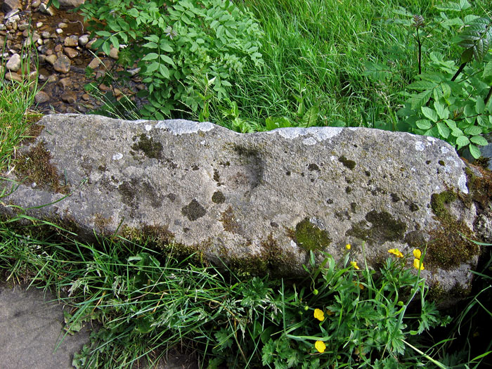
SD96472 33553 The tallest stone, erosion run off on the stone suggests it was in this position long before the reservoir was built

SD96472 33553 Looking North across the remains of Walshaw Dean.

Standing Stone 3 SD 94705 32937 The smallest and least convincing of the stones.

18th Century graffiti on stone 2

Standing Stone 2 SD 94692 32949 The third stone is visible in the background.

Standing Stone 1 SD 94625 32884

Summerhouse Hill Cairn on a miserable, cold, wet day in April 2005
The feature here that is generally assumed to be the cairn is actually the base of a modern summerhouse, the real cairn is at SD50147428 and is a much more discreet affair, being an oval about 12.5m x 9.4m, it consists of a mound of earth and limestone rubble, and is kerbed with limestone blocks. At the centre is a depression, the result of an 1778 excavation which recovered a human skeleton, a large bead, and calcined human bones.
The cairn is easy to locate via the footpath to Leighton Hall from Peter Lane. Almost immediately after going through the gate from Peter Lane the path crosses a tractor track running up the hill, follow this to the left, the cairn is on the left-hand side of this track, just before leaving the trees and entering the area where the stone circle is situated (Directly below the ESE outlier).


05/06/05 Possible cup marked stones incorporated in the pack horse bridge.

06/08/06 Further vandalism at Pikestones, the pounding is being done with a large stone which the attacker is replacing in its original hole after use

Damage at the Pikestones 22/07/06. Compare this with Treehuggers photos taken on the 30/07/06, it appears that further damage has occurred during the week.
Is this a local stone or was it brought in from elsewhere during construction of the reservoir? Living locally I’ve made many trips to the surrounding moors and so far not seen evidence of any other rock art in the Rivington area.


Sited about three quarters of a mile down the A839 to Lairg from the A9 junction, on the Mound Rock, Aberscross is easily accessed being sited on a flat platform a short walk up the slope, however it’s definitely one to visit when the bracken is down, in early July it was completely swamped.


After a little judicious trampling of the bracken the circle emerges.


The largest stone, an aprox 2m high chunk of conglomerate.


A reflection in the clouds is all that is visible at the time the moon should have been setting within the circle 1.27am 10.07.06.

Things started to look good, but within minutes the moon was lost in cloud. 11.35pm, 09.07.06

Lunar standstill moon, taken from Cnoc an Tursa 23.40pm, 09-07-06.
