
A panoramic view looking roughly north
Image credit: Ken Williams/ShadowsandStone.com
A panoramic view looking roughly north

This stone sits beside the field fence, to the north east part of the circle. A low, ruined wall now runs along behind it. Behind is the easily recognisable shape of Patrickstown Hill.


Looking in a south-west direction, Cairn T clearly visible on the peak to the left and a hint of a cairn on Carnbane West to the right.
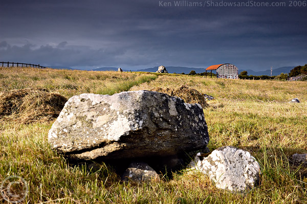
Well this is an odd one! There’s been so much destruction its hard to imagine what originally stood here, but its not anything like a mis-interpretation of a ruined kerb from a cairn as I had thought in the back of my mind. The stones are massive, much larger than I expected, Burl says four are standing but on the ground its a bit more complicated. There are indeed four large stones, as tall, if not taller, than those around Newgrange but only one is quite as bulky. These stand in a sort of bent and stretched square but there are also large stones prostrate inside the area of the circle, to one side is a pile of field clearance or a ruined wall which has a large block sitting almost upright with what looks like packing stones underneath.
Beside another large upright there are two low stones, one about 6ft long and the other much smaller but they seem to arc around on a tangent from what would have been the circle. Very odd. They are much smaller than the upright beside them and look very mismatched but original nonetheless. There are lots of large and small slabs just visible around the place, inside and outside the circle and there is what looks like a large pit surrounded by heaps of large stones (field clearance?) off to the west of the circle, about 150 yards maybe. I didn’t venture over here because of a large herd of tetchy cows and calves watching my every move. Didn’t see any of the rock art Martin Brennan referred to but I think some was carted off to the National Museum in Dublin. Gave up looking in the gloomy light, not a great time to photograph or hunt rock carvings!
The owner of the land seemed ok with visitors but the directions were vague enough to border on the unhelpful so a bit hard to judge. Seemed cheery though so do call in as you have to go through his yard and down a very, very muddy track. Wear good boots and a smile and you should be alright!

One of the large stones still standing in the south west area of the circle, to the left of the stone, on the horizon Cairn T can be seen on top of Carnbane East, and on the far right of the photo is Carnbane West.
Centre chamber, Tomb 4 with 5 on the near horizon


Kilclooney More and its mysterious guardian, this black dog accompanies many visitors up the path to the dolmens* and kindly stood for a portrait in near darkness in September 2005.
*See visit notes!


A pic taken peeping over the fencing surrounding the compound on Sunday 24th Sept, day after the equinox, at 6.41pm, about 40 mins before sunset. This was the only time the sun shined, clouds obscured the actual sunset but the shadow was definitely moving towards the line down the centre of the stone. Unsurprisingly, the only planted tree I could see in the whole compound is placed directly in line with the entrance to the west passage and the setting sun....

On the eve of the Equinox, 22/9/06, sunlight streams down the passageway at dawn to light up the backstone of the chamber.

This looks a bit lopsided but is pretty much level, must be the distortion of the wide angle lens

From across the small stone wall at the car park. The amount of rubbish in the area is truly appalling. I’d hate to bring a visitor up here and find it in this state.


Facing in a southerly direction
As usual the sunlight was a gorgeous golden shade against a dark stormy sky, picking out and magnifying the green shades in the trees. Also as usual, this was while I was on the road between Armagh town and Cookstown. By the time I got to Creggandevesky the haze on the horizon was filtering out the strong sunlight and the lovely stormy sky was dissapating.
This site is signed all the way off the main Cookstown-Omagh road but the very last sign is minisule and green, spotted at the last second while driving down the road. I only noticed on the way back that the site is clearly visible from the road until you park. There is a decent stile there which gives you the false impression that access is easy. I made my way down to the lakeside and decided that the locked gates meant the south shore was not an official right of way, what a fatal error!
I made my way around the north shore which was boggy but passable until you pass the knoll that blocks the tomb from view. Once I got this far around I realised the track ended in a barbed wire fence, on closer inspection it was a DOUBLE barbed wire fence. With the light fading fast there was nothing else to be done so I scaled the fence and soon found myself in boggier and boggier marsh. This meant circumnavigating part of the lake that was overgrown and crossing another fence with soggier and soggier toes. When I was about 100m away from the tomb I discovered the ground dissapeared down into a deep banked stream, a prod with a tripod leg ruled out a crossing attempt.
As luck would have it though I followed it back towards the lake, resigned to not making it to the site when I noticed the stream was covered over nearer to the lake so the only obstacle left was another barbed wire fence and foot deep-holes of cow dung.
Though the fence is far too close this site is really wonderful, though the sketchy access has not deterred the vandals, names were carved in foot high letters on both sides of the tomb entrance and the information board had been smashed and destroyed. Nonetheless the lakeside location and beautiful views soon distract you, the tombs remarkable state of preservation and neat construction easily make this the best court tomb I’ve yet to visit, even better than Creevykeel (possibly because that looks like its located in someones back garden). The tombs construction is better described elsewhere.
I wished I had brought a ladder to get some good overhead views, the sun did briefly make an appearance but even climbing the stile didn’t offer a good overall view of the structure.
On the way back I took the south path around the lake, though be advised that the cows and bullocks here take no s**t, the usual shouts of ‘gerrrrout!’, ‘whisssshhhhhhht!’ and ‘ye feckin JERK!’ had absolutely no effect on the fecker standing directly in my path with his nicely rounded horns. More trekking through deep holes of dung with one eye over my shoulder on the way back to the car...
Dung, mud and bovine bothers aside, this is a real treat and should be visited by everyone who goes to Beaghmore up the road. If there were no fence, marsh and animal issues this would be a truly extraordinary site.


Facing roughly north, the lights of the town of Dundalk on the horizon

In B&W but with the fence posts removed also..

Looking roughly north
I was very surprised at how big this stone actually is, its about 10ft tall but is very wide and is almost banana shaped. It curves in heavily towards the base so it looks like it would fall over only for the sheer weight.
Behind the stone, about 7m away, is a steep, sharp drop down to the riverbank. Below the site is a figure of eight shaped pond, O’Kelly has one marked on an aerial photo as a possible source of material for Newgrange itself but I thought it was much further west.
The stone itself is surrounded by fencing. No problem I thought, I already walked four fields and climed four gates. Zap! Bloody tripod went flying after getting an unexpected shock from the electric fence... None of the other fences were electrified but dont be fooled, this one seems to be permanently on. I’m sure the rabbit I startled on arrival had a great laugh! Ended up taking photos from outside the fencing.

One side of the stone is particularly weathered and grooved, I liked this gnarled side the best!

Looking past the stone towards Newgrange which is on the horizon.

Stone C is quite a massive stone, 10ft in height and 17ft in girth. Newgrange is visible from this stone to the north-west.


By the light of the full moon

The Mound of Hostages by the full moon, the plough is visible in the night sky above. 3mins @ f8.

The partial lunar eclipse on 7/9/06 viewed from the ‘Kings Seat’ at Tara, looking over the Tara-Skryne valley


From this angle you can see the curious stones near the four poster. The small stone which I thought seemed like a sort of axial is not visible but sits between the two stones standing on the far right.

A genuine, bone-fide four poster! To get here you have to go up someones driveway and park at their house, so no matter what your view on one legged people is, if you want to see the four stones you’ve no choice but to knock on the door.
So, knock I did and explained to aforementioned monopodic man that I was looking for the stones, ‘hang on an I’ll switch off the telly’ was the response. I was prepared for a long, convoluted set of instructions. I wasn’t at all prepared for a one legged man to come tearing out from the side of the house on a quad bike.
I gathered I was to follow him in my car, follow I did despite much protest, straight into one field and right up to the gate of the next. Once inside the second field he brought me over to a spot about 60 paces to the north west where he says he discovered a large amount of burnt black soil when ploughing the field some years back. The site itself has not been excavated but he told me of a megalithic kist found nearby in the village which contained a burnt skeleton and some pottery.
Aubrey Burl says in his guidebook that a ‘playing card’ outlier sits 14m or so from the main site with a quartz block beside it but there was no trace of either. Then again Burl thought this site was in Waterford. There are a few large protruding stones quite close and a small square stone less than a foot high which looks for all intents and purposes like a miniature axial stone on the ‘west’ side.
I was very impressd with the site, the view and the intriguing confusion about the place. The farmer is one of the nicest I’ve met, up there with the farmers at Reanascreena and Carrigagulla so don’t hesitate to call in for a look if your anywhere nearby.


This is looking north I think, this used to be the ‘bad side’ according to Fourwinds pictures but has now been promoted due to the fact that the other side is now invisible.
Oh-dear oh-dear oh-dear... Almost complete ruin isn’t the last indignity for this tomb, just to add a pinch of insult it now has a tree growing out of its rear end and a thick growth of brambles and nettles on its, cough, ‘good side’. It was almost as if it knew I was only here to avoid the traffic through New Ross. A dirty pox on that nuisance of a town! Its so bad even the main road out of the town brings you back into the town at the other end, gah!! Anyway, this snivelling wreck of a monument is probably only worth visiting if you are dropped into the field after an alien abduction. I’m sure it was quite nice in a former life but alas, no more.