
Fontburn a (v); cup-marked boulder (150 x 100 cm), N side of Fallowlees Burn.
Image credit: Rockandy
Fontburn a (v); cup-marked boulder (150 x 100 cm), N side of Fallowlees Burn.

The four-poster stone circle from the W, well described by Hob’s field-note. Two stones have cup marks corresponding to Fontburn c of the Beckensall archive.

Fontburn c (ii); the N’most boulder of the stone circle, taken from above, showing the large cup. The Beckensall archive records and illustrates 6 cups on the top and a double-ringed motif on the inner, vertical face.
Hob’s cup marked boulder (see photos), just W of and in sight of Fontburn b, does not correspond to the other marked rock in the Beckensall archive, Fontburn d. This is located further to the NW of Hob’s stone on the opposite side of a small stream just N of the bridle way (NZ 031 935).
The Beckensall archive describes Fontburn d as having four cups, one elongated, on the SSE face and two cups on the E face. The top surface of the boulder also has prominent grooves and these don’t look particularly natural. The boulder is said to be located in the centre of a denuded cairn and there is another, more complete cairn further down the ridge towards the reservoir.
There are clearly other marked rocks on the S side of the Fallowlees Burn in and around the old enclosures further W (see, for example, the Fallowlees site post).

Cup-marked rock, Longstone Hill, Lucker Moor.
The rock with a large basin-like cup is approximately 60m NW of the Long Stone just below the edge of the escarpment (NU 1185 2706). Is it a natural erosion feature or man-made?
Although no marked rocks are recorded in this position in the Beckensall archive many are recorded from S of the Lucker Moor cairns and W of Lucker Moor at Chatton Sandyfords.
Most rock on the moors may have been moved into field-clearance or the many burial cairns at different stages in the history of man’s use of the area.

The Long Stone standing stone, Longstone Hill, Lucker Moor; view NE towards the coast. I have not been able to find out the age of this stone and it is now set in concrete. It is present on OS maps from 1856-1865. The 2.5m tall stone is NE of the Three Cairns of the Longstone Hill Bonze Age Cairn Cemetery and commands a fine view.

Two of the three large cairns on Longstone Hill, Lucker Moor. These cairns are part of about 40 round cairns, making up an extensive Bronze Age cemetery. The large cairns are approximately 20m in diameter and 2m high but much stone has been removed from their centres.

Possible new cup-marked stone, S of the Wandylaw cluster. This slab appears to have a large cup near to one edge and the eroded remains of an OS bench mark on the surface. Is this a prehistoric carving or something more recent?
The portable slab lies next to the Parish Boundary fence close to a Boundary Stone and footpath (NU 1376 2434). Old maps (1856-1865) show the presence of a Sharplaw Cairn near to this site and also the OS survey point of 600ft.

Wandylaw a; large sandstone boulder with cups and grooves on the top surface. The stone has probably been quarried and may not be in its original position.

Wandylaw a; view NE towards Bamburgh castle and the coast.


Rock close-up showing cups, partial rings and the ‘paw print’.


Tod Crag from the SW showing its position on the edge of the (now felled) plantation. The N part is heavily quarried but the single panel of rock art is simply stunning.

View S from the dome-shaped rock panel to the track and trees at the W end of North Plantation, site of the excavated Fowberry Moor barrow. This photgraph is in the same orientation as that illustrated in Beckensall (2001) p.61 but there is now much more rock surface exposed on the foreground slab. The large cup with four rings (shown in detail in a separate photograph) is on the S’most slab and the Weetwood Cairn-like motif with three radial grooves left of centre.

Fowberry Mains/Park (b) (Beckensall 2001) rock with linked cup-motif. View W towards North Plantation (site of the Fowberry Excavation Site) and Whitsunbank.

Fowberry Mains/Park (e) (Beckensall 2001: 65) but now heavily encrusted with lichen and difficult to see the motifs clearly. View to the SW towards Chillingham and Ross Castle.

Nicely made cup with four rings and other scattered cups.
There is a large and possibly cup-marked rock (see photo) at the location of the site marked on the 1:25 000 OS sheet (NZ 022937). It is heavily encrusted with lichen with the rest partially covered in moss and turf. It is on the slope just N of the Fallowlees Burn to the E of the bridleway. The cups on the visible surface are certainly not deep, and I was not clear at the time of my visit if this was the stone referred to by Beckensall (2001) as Fontburn (a). No illustration appeared to have been published. Recent comparison with images in the Beckensall archive show that this rock is identified as Fontburn a (i), 185 x 135cm, in its original location, with a minimum of 15 cups.
The Beckensall archive describes three more marked rocks in the vicinity, all of which I missed on this visit, unsurprisingly when you examine the photographs. My eyes and experience are no match for Stan’s.
There is a very nice, deeply cup-marked rock to the west (NZ 018936) between the forest and the Burn (see photo) just W of the Settlement. There are many rocks in the area but this was the only one with clear markings. The rock is very close to the ground, about 60 x 30 cm in size, with four prominent cups (three deep and one shallow). High ground surrounds on all sides and the only view is E down the valley towards Fontburn. I thought this was a new find and was quite excited. Recent examination of the Beckensall archive shows it as Fontburn a (vi), where it is considered to be a portable, reused stone, possibly part of a burial cairn. Perhaps this is the origin of many of the scattered rocks in this area, including the large number of smaller rounded cobbles on a slope above the burn.
I photographed another cup-marked large boulder SE of this stone which corresponds to Fontburn a (v) of the archive (see photo), but missed (vii) and (viii). The marks on these were either not particularly prominent or I mistook them for natural erosion.
It would be interesting to explore further up the valley but the forest would perhaps make this impossible.
There is also an earthfast boulder with a possible single deep cup in front of Fallowlees Farm, right next to the bridle way (see photo) but I am much less certain of this one because of its position.

This is the same rock described by Hob on the S side of Fallowlees Burn showing the view E towards Fontburn Reservoir and the site of Fontburn (b) (Greenleighton Hill). Several rocks in this area of ancient enclosures have interesting markings but it is hard to tell that they are not natural. This rock lies further E of the location given by Hob, within the enclosure that meets the wall (the gate can just be seen to the right) at approximate grid reference NZ 027 936.

View of the site from the SW towards trees surrounding Fontburn Reservoir. The sheepfold with the tree in the middle (not shown on the OS map), described by Hob’s fieldnote is in the centre. The boulder with the single cup lies in bracken just to the left while the main rock can be seen over to the right next to the plantation.
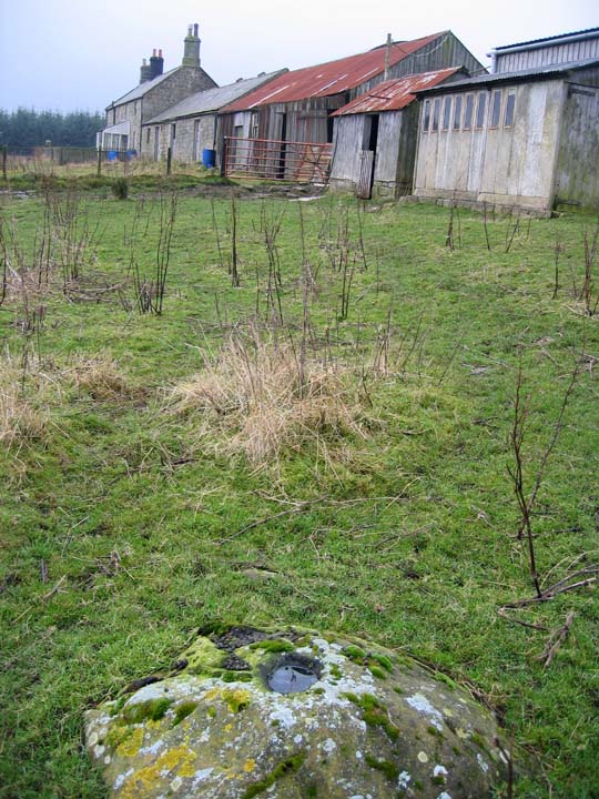
This earth-fast boulder lies close to the Fallowlees fam-buildings. If it had been on the moor I would have been more confident about the single large cup in the top surface. Is it a cup-marked rock or something more recent?

Fontburn a (vi); view E from the rock, down the Fallowlees valley towards Fontburn Reservoir. The rock with three deep and one shallow cup is in the foreground with the Settlement adjacent to the forest on the left.

Fontburn a (vi); a deeply cup-marked rock to the west of the site marked on the OS sheet. Approximate Grid Reference: NZ018936.
The rock lies in among many (apparently unmarked) rocks just W of the Settlement between the forest and Fallowleas Burn. The rock is approx. 60 x 30 cm and has three deep cups and one shallow laid out in a shallow arc.

Fontburn a (i) in the Beckensall archive; this boulder is close to the site marked on the OS 1:25,000 map, SE of Fallowlees Farm, just E of the bridle-path and N of the Burn. It appears to be cup-marked but has a heavy covering of lichen.

Hob’s cup-marked boulder looking towards the main rock on the edge of the plantation. Grooves and other possible carvings show up in the oblique winter sun.

View towards Simonside; main rock under trees to the right.

Upper surface of main rock (Fontburn b). The crack in the rock is shown in the Beckensall (2001) drawing (page 117) running from bottom left to top right. In this photograph, two cups with partial rings are to the right of the crack, the leftmost with an arc above of three cups. This same motif is repeated in the right hand ‘paw print’. The Beckensall archive records 79 cups, some with arcs or single rings.