


The angular bit at the bottom is presumably unweathered due to having been below the soil level. Or it could be fluke.


The Piper’s Chair is visible in the middle of the hillfort, if you look carefully. The bracken just about shows the banks and ditches.

Artificially enhanced basin. Presumably recent, but why? Could it be be an indicator of some old tradition based on the water in the natural basins, which survived until relatively recent times?


Possible cup mark in one of the veins of quartz pebbles embedded in this rather special bit of rock.


Seen from the middle of the fort, you can see the two side pieces which have broken off, possibly as the result of people banging about on the top, possibly as the result of time and gravity, possibly a bit of both.

Eroded rings, weathered cups and enhanced natural grooves.
It’s those Simonside Hills again. This time viewed from Hallion’s Rock.

The panel, with the jubilee stone (modern) in the background as a handy marker.

Where the wall/bank has been cut by a newer track.

Overgrown with bracken. Might be easier to see what’s what in the winter.


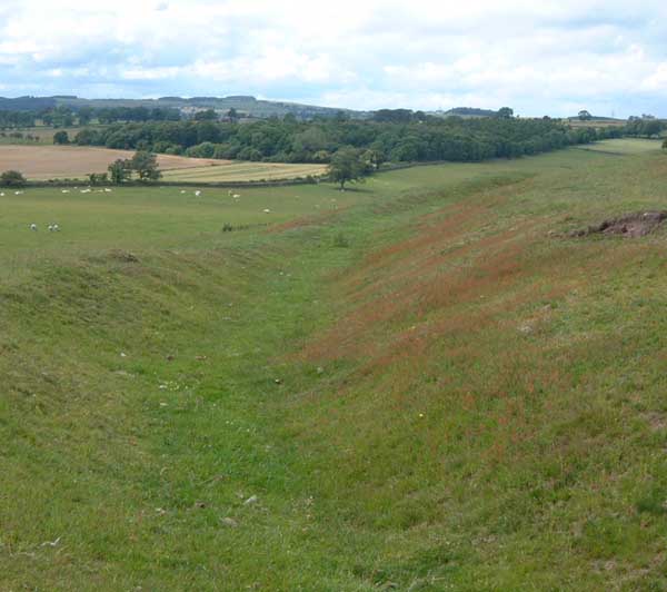
Only the western side of the fort still has well preserved ramparts and ditches. They’re not particularly spectacular, about 4ft at their tallest and the ditches slightly wider.
Patches of erosion reveal the grounding stones, possibly the remains of facing. There seems to be an entrance still visible. The original ramparts must have covered quite a larger patch, roughly 150m diameter, assuming the fort was vaguley circular.
Careful at the south end, there’s a drop down a cliff into a small disused quarry.

Hitherto unrecorded cups and grooves in a burial mound?

It’s a rubbish pic, but there are cups and grooves on this stone, and a patch of what looks like unfinished pick marks.


When you see this cup marked stone as you enter the field, look left to the edge of the conifers.

There are cups on the tops, reminding me of those at the Goatstones fourposter.


The hill to the west. There’s a similar one to the east, each with artificial features. Together, they frame the little monument against Simonside.
“A farmer told Lewis Edwards in the 1940s that when he approached Carreg-y-Bucci (The Hobgoblin Stone) – on top of a prehistoric mound near Lampeter, Wales – with the intention of breaking it up for gateposts,
‘There was a violent thunderstorm, the worst I have ever known. I ran for my life, but it followed me all the way home’.
Three men had been killed by lightning alongside the stone.”
From ‘Places of Power’ by Paul Deveraux.

A rather nice bit of portabe rock art found in an adjacent field.


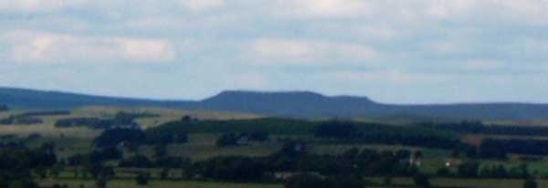
Simonside is the focus of this site. The stones are placed at just the right spot to show only the distinctive ridges of Simonside against a flat horizon.
According to locals,the Piper’s Chair has long been the site of gatherings, with people visiting at special times of the year to make offerings in the rain filled basins on the top of the rock.
In recent years, pagan types have been known to congregate there and ‘dance about like loonies’ according to a local resident.
Tales of ghostly white figures are possibly attributable to the alleged presence of a nearby monastery. Attempts to find it and determine what kind of monks, came to nil.
I still haven’t been able to find out where the name comes from. Though the site is named as both ‘Piper’s chair’ and ‘The Punchbowl’ on the old maps. The punchbowl being the font-like carved bowl, which apparently was put there in the late 18thC as part of party celebrations, and filled with booze. Libatory continuity?
Bivallate hillfort. The banks and ditches of the fort are quite visible, but not particularly large, about 3ft above ground, the ditches maybe 5ft wide. The earthworks are mostly on the northern side, as the southern side is a rather steep slope, more of a cliff with ferns.
At the top of this cliff, easily visible from the A696, is the formation known as the piper’s chair. It’s a large flat oval of rock, about 15ft by 8ft across. Either end has broken off, otherwise it would have looked even snazzier. It’s striking profile is the result of it sitting atop a stratum of much softer sandstone. The same quartzy stone used in many of the megaliths in this part of Northumberland. The soft stuff has eroded, leaving the harder disk sitting like one of those rocks in a road runner cartoon. The harder disk also has a couple of veins of quartz pebbles embedded through it.
On the top of the chair, are numerous basins, some of which are natural, some of which look enhanced, one of which has been carved with metal tools to make a font-like basin with a strange shelf to one side.
It’s littered with modern graffitti from the last century, but part of this is the creation of a handy foothold on the east side, making it easier to climb on the top.
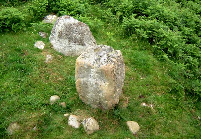
A substantial (3m tall) boulder at the foot of the crag upon which the Piper’s chair sits is named on the 1866 map as ‘The tailor and his man’. In a curious echo of the nearby ‘Poind and his man’.
There’s not much to see above ground here. But there are some banks about 4ft high, and some apparent hut circles.
The banks are stone and earth, as can be seen clearly at one point where they have been cut through by a more recent track. It’s in an eminently defensible place, with a nearby fissure by the name of Long Byres, hinting at the possibility that this was a good spot to keep cattle penned.
In July, the bracken occludes the earthworks, but in winter, at sunset, this will be a much more visually satisfying place. but perhaps not particularly accessible.
This motif gets a mention on page 122 of Stan Beckensall’s ‘Prehistoric Rock Art in Northumberland’.
However the map ref given in the book is a few nundred metres out. it’s best found by finding the ‘Jubilee stone’ off to the north of the path leading from the Poind and His man and the Middleton stone.
The motif is on the bedrock about 3m NE of the memorial stone. Note that the Jubilee stone is not prehistoric as some web sources imply, but it does give a good idea of how the stone used in prehistoric monuments erodes. It’s only been there a hundred years, and the words are galready gone at the top. The fact that it’s made from the quartzy sandstone made me wonder if it had once been a menhir.
It’s a simple, heavily eroded motif, consisting of 6 cups, one with a ring and an arc, another with a ring. The natural surface of the rock has been pecked to enhance natural grooves.
The site has excellent views to the Simonside hills.
I’m not sure if the record in the county SMR implies the stone is not in its original setting, or that it may have been removed all together.
If the latter, then no worries. It’s still very much there.
Like other stones in the area, it has the apparently obligatory (for south Northumberland standing stones) view to the sacred hill of Simonside.
Like others in the area, it is also made of a sandstone that weathers into dramatic vertical grooves.
Like others in the area, it is rectangular in cross section, on a rough east/west orientation of the wider face.
Like others in the area, the stone contains chunks of quartz.
Unlike others in the area, it has no visible cupmarks, and the bottom part is visible, showing very clearly the extent to which the stone has weathered since it was erected. Above the level of the surrounding soil, the NW edge is heavily weathered, below this, visible as a result of the sheep and cows using it as a rubbing stone, the bottom is very rectangular and unweathered. Deliberately shaped even?
It is this anomalous aspect that may suggest it is no longer in situ, as livestock activity at other stones hasn’t resulted in the revealing of this kind of feature, but it is the kind of thing you might expect if it had been relocated, or re-erected. There’s been some extensive quarrying of the nearby crags, and the field the stone stands in is in the route of the exits from the quarry.
One thing that I am becoming more sure of, is the choice of stone from a particularly quartz rich substrata must have been deliberate. It’s unlike the majority of the stone in the area, being found mostly in the standing stones. Presumably it’s not very good for buildings. It has made me think twice about a discounted gatepost I saw on the way though.
The slopes either side of Fallowlees burn are “an area of prehistoric enclosures and barrows”. So quoth Mr Beckensall. There are a number of circular ditched features, at least four inside a 1.5 mile radius of the reservoir, the easternmost being Nunnykirk. It’s been suggested that this is a ritual enclosure, as it doesn’t seem to be a defensive feature, but it’s not alone. There is a small circular ditch at approx NZ036937, only about 10m across.
A larger one, on the southern side of Fallowlees burn is larger, is perhaps 30m or so in diameter. As many sites in the area hint at multi-phasic use, dating these features is not possible without the pro’s coming in and doing their stuff with the harcky-ological technique. But 3 things that can’t be denied are the recorded examples of rock art, which may be taken as a clue that at least some of the enclosures in the area are prehistoric, whatever their purpose may have been, ritual? Cattle? Rituals involving cattle? No-one knows for sure. The marks on this stone, if confirmed as rockart, would raise the number of sites to 5 (if the boulder near the table slab at Fontburn is taken as a separate example)
This simple, but typical, example of rock art is set a few metres away from one of these enclosures, in a patch of nettles that stand out like a sore thumb, indicating something going on underground. The stone has at least 4 cups and 2 grooves, and though prone, may have been upright at some point. It is in the middle of a small mound, and is not marked on the maps, nor is it mentioned in any lists or books I’ve seen. It’s easy to spot the patch of nettles from the bridlepath, with the stone peeking out.
This is the table like rock described in Stan Beckensall’s ‘Prehistoric rock art in Northumberland’. I think the grid ref given in the book may be a little off, as the stones is maybe 150m to the north east of the ref given which caused minor searching to begin with, but the photo in the book showed it is on the edge of conifer plantation, near a gate.
Approach from the bridlepath linking Newbiggin farm with Greenleighton farm, where the land rises towards the sheep pens marked on the map, turn left, and head towards the sheepfold with the tree in the middle (neat little structure that it is). Here there is a boulder with a single easy to spot cupmark. Look to the left, and the table-slab is visible lurking beneath the conifer branches. It has a strong presence, despite, or maybe because of the way in which it seems to be trying to tuck itself away. Unfortunately, the trees obscure the view, so it’s hard to say if it could have a line of sight to the four-poster on the other side of Fallowlees burn.
Big Stan counted over 80 cups, pushed for time, I didn’t even try and check, as some are very faint. The rings and arcs were visible, and I found myself in total agreement with the observation that whilst the slab is reminiscent of Old Bewick, the motifs are much simpler. The setting isn’t anywhere near as good as Old Bewick either, but I really felt this slab has a presence. Despite effort not to do so, I couldn’t help but imagine it slouching into the trees, grumbling in a Gilliamesque kinda way. It’s undeniable that this is a good example of several species of small, simple motifs, gathered together on a slab, possibly even grooved together with a pick.
Placed deliberately in view of Simonside. if this little four-poster type circle were a few feet further north or south, the hill wouldn’t be half as visible. The long hillocks to the east and west frame the plateau with Simonside as the definite focal point, almost due north. You simply can’t miss it, with it’s distinctive shapes being silhouetted quite precisely, none of the curves of the lower foothills of Simonside can be seen, which adds to the visual impact of the setting. It would be such a sight if viewd at night with the aurora borealis flickering behind it.
There are more than 4 stones, but the largest roughly describe a rectangle. All the stones are on a low mound, with many small boulders dotted about, possibly they once covered the larger stones. Burl declared this site a four poster, and the mound certainly seemed to hint at a burial function that would fit with the four poster label.
Stan Beckensall states there are cups, and some of these were clearly visible on the tops of two of the stones. But the ringed motif on the vertical side of one eluded me.
Growing from the south side, there’s a hawthorn of great age, most of which has broken off, the depth of the lichen on the split wood indicating it was a long time ag. Yet happily, the tree survives in reduced form. The strange hillocks framing the miniplateau upon which the sire sits are very conspicuous, that to the east having revetted stone walls, with traces of a ditch. The western one has some pretty hefty boulders as grounders of two parallel linear earth/stone banks, each of which is runs the length of the hillock. No excavations, no dating evidence, no idea. Though cattle droving suggested itself.
It’s not particularly accessible in any way, requiring a scramble up from the footpath to the south by the burn, or a trudge across bracken infested bog to the north, moss-trooper territory, with hidden hollows, steep sided cleughs and mossy, peaty moorland. Shame about the pine plantations.
This site is not marked on the OS map, nor is it scheduled, which seems a poor show. There surrounding area is littered with intriguing lumps and bumps, such as the circular ditch on the path from Newbiggin farm, just before the trees.
The place to ask permission is Newbiggin Farm, and though there are carparks on the eastern side of the reservoir, it’d still be a hike of a mile or so across some burns, through quite a bit of mud, along some pretty basic trails. If coming from the west, from Harwood forest, beware the recent tree felling has blocked some of the footpaths and bridleways, many of which might be easy enough on horseback, but are a right pain on a pushbike, even without the trees.
The grid ref here is for the cup marked stone marked on the OS map. Tree felling has trashed the area, and it is now covered over, and impossible to find.
It’s described in Beckensall’s ‘Prehistoric rock art in Northumberland’.
Short account of the Arthurian connection, with reference to Cummings Cross.
I can’t help think the tale of the warrior in the hollow hill may be an echo of the person in centuries past, who discovered the burial cist on Haughton Common.


Sometimes Rock art can be tricky to find. Not here though.
Straight up the path from the carpark, turn left, look for the big rock covered in carvings. Just in case the rock is feeling bashful, the main panel has a slightly quaint signit is virtually impossible to miss.
As ever, a copy of the relevant Stan Beckensall doesn’t go amiss.
A great place to start a jaunt up Simonside, which must surely be the focal landscape feature for this area’s rock art, though it does have a good vista over the nearby river valley (that of the Coquet), as is apparently desirable in a suitable site for cups and rings.