Crossings Guide to Dartmoor tells us that the name Plague Market and also Potato Market came about when the nearby town of Tavistock was ravaged by the plague. The moorland people would travel to this site to leave food for the townsfolk.
He also states that the round stone is infact a millstone carved by a local who then decided it was not fit for the job
Boxing Day 2004
Fantastic day for walking, not a cloud in the sky. The line of barrows stood out as we climbed the hill from Nine Barrows Lane their numbers increasing as you ascend the hill. At the top end there is what looks like a dug into barrow until you get close and realise it is just the earth that has been thrown out of a long ditch. I would guess this to have been created by miners looking for traces of lead (there is a large lead mine to the east in the valley)
As for the ditch the other side of the barrows, I am not sure. A gap has been left to allow the route of the path from the Priddy Circles to the Nine Barrows to pass and in my expierience it is unususal for miners to dig one long even trench.
I have never come across so many barrows in a small area, this must have been an impotrtant site. With the four henges so close by as well, I can see I will have to do a bit of studying.
Boxing Day 2004
In order to work off the festive feast decided to drag the outlaws up to Priddy for a walk. Didn’t mention my reasons for choosing the area...
Walked up through the barrows that fill the area to the road beside the henges.
Stood on the gate and looked into the field containing them but could not make out where they were. Didn’t enter as there were horses in the field and one of my fellow walkers said that the land was owned by the local hunt kennels, not the sort of people who welcome trespassers! even during the festive period.


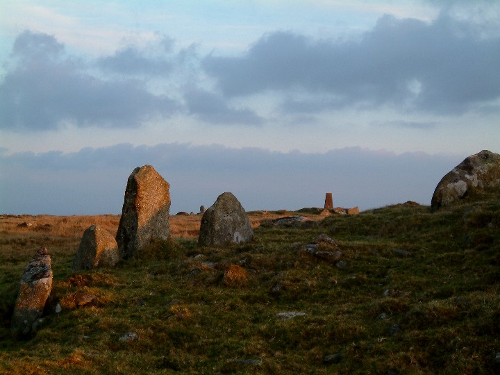
This cairn on top of Great Care Hill looks like it could have once been a ring cairn...very knocked about, just outside of firing range danger zone. St Bellarmins Tor in distance on left.
Extract from the Cornish Times 12th January 1901:
It has been reported in the national press that during the recent storms one of the upright stones at Stonehenge toppled over. This in turn brought down one of the cross stones. The upright which has gone down is in the centre of the three standing on the North West side, the cross stone has broken in two and in the words of the Daily Mail “looks to be made of some sort of composition”
It is more than a century (1798) since the last fall of sandstone (?)
It was reported later in the year that the damage done at Stonehenge was due to tourists! They erode the ground around the stones causing a build up of water. This softens the soil and when storms of the magnitude that hit Britain over the New Year 1901 occur, can cause structures to fall.
This is not word for word but taken from notes, Mr H
Although I have put this site in under cairns it is more than that...but I was not sure if sacred hill was quite the right description.
3 Dec 2004
Bray Down is the most northerly hill of Bodmin Moor, and I must admit I had never explored it until this week. Not that it is hard to reach or access, just that it had never looked that interesting. As it is I had noticed that there was a settlement marked on the OS map at SX191826, just above the road that runs from Altarnon to Davidstow Moor. Being in the area I decided to drive up and have a look.
I parked the car at Bowithick where the river is forded and a track goes off onto the wild moor below Buttern Hill. From here it is a plesant walk along the very quiet road back to where the settlement should be. After a while a muddy track heads off up the hill at a slight angle and I decided to follow this for a while before cutting back to the settlement.
That was the plan....
Then i noticed an abandoned farmstead ahead and went to have a nose....nothing ancient, well perhaps mid 1800s but still got me interested. After exploring the four cottages and adjecent barn I headed uphill to the summit. The views over the wild northern moor were superb, it is a very lonely empty place up here, no signs of habitation at all, no signs of roads, very few “landmarks” just rolling moorland.
But just to remind you that you are on Bodmin Moor the twin hills of Brown Willy and Roughtor stand proud to the west...and this afternoon they are silhoetted by the sinking sun.
On the summit of Bray Down are two cairns, one has been vritually destroyed and a trig point sat in the centre of it whilst the western one has been dug into but is still a mound. This could be something to do with the fact that it seems to be, like Showery Tor, a cairn built not over a burial site but around a natural feature. Two sides of the cairn have been dug into but only as far as the natural rocks. On the northern side three uprights remain on the edge of the cairn.
With the sun sinking I open the flask and pour a coffee, put on my coat and wait...the sun turns the rocks around me orange (and possibly me as well) before it dissapears behind clouds coming up from the west. It is time to move on..
I descend back down the hill to the car, the light fading with every step. As I reach the car I remmember that i was going to look for the settlement...oh well, goood excuse to come back.


Late afternoon, 2nd December 2004. View of Roughtor and Showery tor from Bray Down.
I can’t believe it is three years since I was last up here, and it’s still bloody cold! Stannon circle is in danger of being hidden by the grass. When I last visited it was being grazed by a flock of sheep that watched over me like hawks.
It is fast approaching dusk as I drive up to the circle and I must admit I drove right up the track to get as close as possible. Good job too, as my battery in my camera chose to go flat after about three shots!
After running back to the car and changing batterys, and having a sip of coffee, I venture out again into the biting wind. No sheep, no people... a dozen or so ponies cross the horizon to the south east and a flock of stirlings head towards Roughtor... and me. The sky starts to turn pink as the sun drops behind the cloudbank building in the west... will I get a sunset?
No! I decide that it is not worth the wait and head back to the car and the coffee. As I am about to leave a people carrier turns up and family and dog fall out... I leave the circle and the fading light to them.
As I drive home a huge moon rises over the moor... if only I had remembered...


Just had this reply from Steve Hartgroves, Principal Archaeologist
Cornwall Historic Environment Information Team
“The circular feature on the map has been surveyed and examined by the OS archaeological surveyors; they were unable to come up with a convincing interpretation.
The SMR says this:
PRN 1782: A roughly circular enclosure lying at the bottom of a gentle SE slope immediately above an area of marsh was located and surveyed by the OS in 1973 and surveyed from the air and on the ground by the RCHM in the 1980s. The enclosure measures 35m in diameter overall and consists of a turf bank up to 12.0m wide, and nowhere more than 0.7m high with a few exposed stones. There is a depression in the centre, but no trace of an entrance, and no sign of any round houses in the interior. In 1973 the OS recorded that its origin and purpose were ‘obscure’, but added that it may possibly be a small round. In 1984 Quinnell’s view was that it was not a small round as previously suggested, but possibly a natural feature. This seems unlikely however; excavation may be needed to properly identify the function and date of the feature.
I don’t suppose this is much help...it isn’t likely to be a round in this location; could it be some kind of animal pound?”
I am not convinced, it aint natural that much I know!
watch this space

Found this whilst out walking last week. Not totally convinced that it isn’t a rubbing post but...
It is a large stone for a rubbing post, about 4ft high and around 2 ft wide.
It lines up nicely with Brown Willy.
Why erect a rubbing post when ther are walls, trees and barns nearby.
It is natural in shape, ie has not been cut by man.
To look for yourself take the footpath from the east end of Davidstow Airfield, very muddy at Oldpark end. Once past the barns at Oldpark turn right down wide track, the stone is in the field on the right.
I recently purchased a couple of old maps of Bodmin Moor, one is a military map from 1946 the other is from 1961. Both mark a fogou on at this grid ref just north of Brown Willy. It is still marked on Os maps as late as 1970 but is not on the modern Explorer.
This is one area of the moor I am not too familiar with and it is also an area best not ventured into in deepest winter.
I will keep you all posted if I find out anything.


This can be found by taking a lane running north of the village of St Neot towards Colliford lake. When the road turns into a muddy track, the mound, as it is marked on maps, is just inside a gate on the right.
In Robin Payne’s Romance of the Stones it is called the Penkestle Menhirs and is described as a multi phase cairn, the standing stones being added at a later date.
The mound does lie on private ground, but a quick hop over the gate isnt gonna upset anybody.

Letter Moor is a small area of open moorland just to the south of Colliford Reservoir and north of St Neot. On the OS map a couple of cairns are marked plus a tumulus just to the south in a field. Slap bang in the middle there is marked on the recent OS Explorer maps a dotted circle, i was curious as to what this was so took a walk.
The whole area is made up of very gently slopeing moorland with gorse bushes here and there. There are a few lumps of granite poking up through the soil, I did line up five with a large stone at the southern end but decided I was imagining things...
I wandered around trying to see what the round object on the map could be, there was no obvious feature. Then I turned round to look at where I had come from and spotted it.
Lying on the gentle hillside and facing south east was a low earth circle with a depression in the middle. The circle was about 75ft across from bank to bank. There was no sign of stone in the low banks and the centre was very smooth all round.
I have no idea at the moment what this feature is but will look into it. It may be a cairn or tumulus but there is no sign of the earth or rock that must have made up the inside.
One other inteeresting feature is the fact that looking east from here I believe the sun would rise over Brown Gelly on Midsummer day whilst all the other high points of the eastern moor are equal distance in a row moving south

Found this on Ebay...dont know the date...what are those bands round the stones? Also look where the cars are parked.

A footpath runs right beside this impressive hill fort on the south west edge of Bodmin Moor. The views are fantastic and the fort itself is in good condition despite cattle roaming all over it and large badger setts nearby.


This is thought to be the entrance to Berry Castle from the south. It uses the natural rock formation to good advantage.


Mentioned in the CPRE report of 1930 as the “Eddystone” at Musick-water.
The coat of arms of the Tremenhere family show three standing stones. The meaning of the name in Cornish being Tre= farm or home and Menhir= stone.
Why they should put three standing stones I am not sure.
Mentioned in 1930 CPRE report as being blocked.
Recorded in CPRE report of 1930 as blocked.