
rockartuk


Warrior’s Rest Standing Stone in front of the cottage in March 2003

This decorated stone was shown to us in May 2004 by the friendly farmer who found it in a old stone wall with the decoration facing inward. The stone is now ‘on display’ in the farmyard behind the gas-tank.


We visited the site on the 8th of June, a couple of weeks before Greywether. What struck us first of all was the state the motifs were in. So much more weathered than a couple of years ago. Furthermore there was a black area near the rosettes -also seen on Greywether´s pics- which consits of dead mosses. The substance felt like tarmac and it seems as if the mosses were burned or manipulated with some sort of -acid?- liquid. There could be a natural reason for this weird phenomenon as well. But in that case it is strange that it is seen in only a small, limited area.
We brushed some pine-needles away at site 2 to clear the long N-S panel in the wood. On former visits we weren´t able to make much of it because of the thick moss-layer which we left in place then. But now we were more lucky and photographed the splendid motifs. Had we known that Greywether was following our trail we would have left the needles of. Sorry, mate!

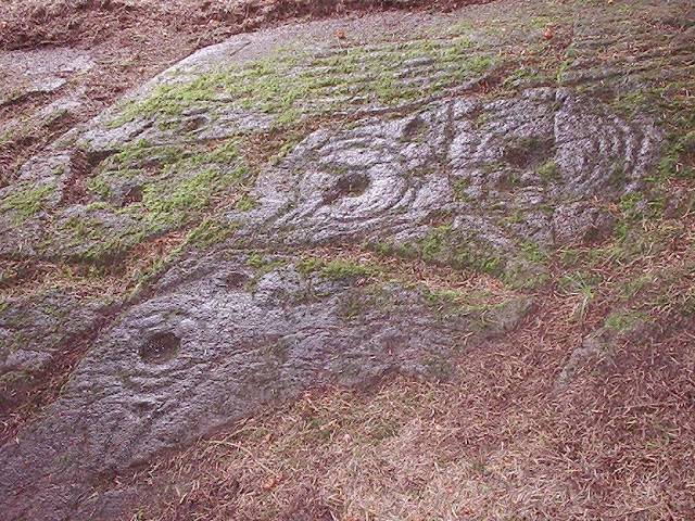
The main panel with the “rosettes”. Note the black area near the rosettes.


The most Northerly carvings on site 2, a steeply slooping finger of bare rock

Unusual motif halfway site 2; the outer -third- ring runs down with a groove.

A nice panel of rock art in the middle of site 2. The seven -not as short as mentioned in the inventory- parallel grooves, grown over by fresh moss, are clearly visible. These parallel grooves are a most unusual feature for Scottish rock art.

Site 2, the slooping finger of bare rock, seen from the N. The decorated panel is about 6 m long and fractured.

Site 2, the beginning of another rosette. The fresh moss was intentionally not cleared away because this may damage the motif.
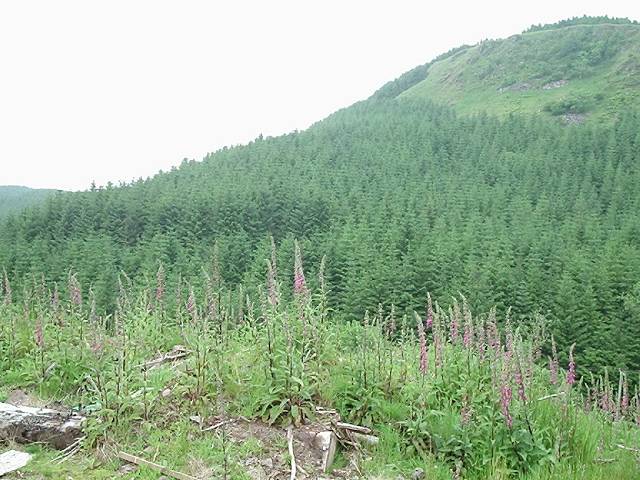
View to the site from the road. The location can be seen just over the top of the highest foxglove. It is clear that the main panels are on a terrace which is not planted with trees.


Site 4, the whale-back with the covered terrace on the left. On the 6th of June 2004 we carefully unearthed the terrace.

The unearthed terrace has a bended surface, just like a bridge, with the highest point near the middel of the panel.

Site 4, the North end of the panel with the cup and one ring and seven or eight partial rings some ending in a cup. An unusual but wonderfull design.

Site 4, the South end of the panel with “fresh” cup-and-rings, some in a cartouche, mirroring site 5.

Site 4, the wet South surface with the two cups with one ring in the cartouche clearly visible

Site 4, looking South, as we left it after the excavation; safely covered again!

View from site 5 to site 4. Site 4 (the whale-back) lies to the NW, behind the fieldwall along a track, left of the tree on the right side of the photo. The terrace is just visible in front of the whale-back

A view from Stroneskar to the East. Glasvaar Farm is in the middle of the photo.

Site-1 (NM80SE 33); an erratic boulder with cupmarks in a field 200 m SW of Glasvaar farmhouse

Site 2: A cup-and-ring marked boulder, incorporated in a wall in front of the farmhouse, just under the big tree.

Site 2 (NM80SE 50), a cup-and-rong marked boulder in the wall in front of the farmhouse

Site 4, cup-and-ring marks on a whale-back outcrop N of the farmhouse. The outcrop has two decorated surfaces, one on the crest of the ridge and one, with complex carvings, on a terrace direct to the East (on the photo on the left side) covered by a thick layer of turf. This photo was made in May 2002.

Site 4, the crest of the whale-back with cup-and-ring marks and a (later) knocking stone basin.


Site 5 (NM80SE 49) a gently sloping rock sheet with a.o. two cups linked by grooves set in a cartouche

Site 5, detail of the two cups linked by two grooves set in a cartouche


In PSAS, Volume 10 (1872-4), p.288 and Plate IX there is an article by Andrew Jervise “Notice regarding a “Pict’s House’ and some other Antiquities in the Parish of Tealing”. The cup-marked slab is on the left. The stone with the “mussel” shaped cups was reported to be lost but it could well be the “cup-marked” stone photographed by Hamish in October 2006.

