
Taken 26th August 2002: This shot was taken from the road, and shows the stone sitting in a v-shaped slice in the bracken on the far side of the field. Nant Lwyd (Lwyd stream) is behind the stone in the trees.
Image credit: Simon Marshall

Taken 26th August 2002: This shot was taken from the road, and shows the stone sitting in a v-shaped slice in the bracken on the far side of the field. Nant Lwyd (Lwyd stream) is behind the stone in the trees.

Taken 26th August 2002: This Bronze Age standing stone is relatively easy to find from the road. I exercised my right-to-roam and wondered into the field to take this photo.

Taken 20th July 2002: Here are the Buwch a’r Llo stones close up. Whenever I drive through here I stop the car and say hello to them. There’s rarely anyone around, so I don’t have to worry about being locked away!
Just visible above the Llo stone (i.e. the smaller of the two), below the light grey horizon, is Dinas.

Taken July 20th 2002: This shot gives you an idea just how close to the road the Buwch a’r Llo stones are. You can’t really miss them. They’re on the right-hand side of the road after the cattlegrid, coming from the Penrhyn Coch direction.

Taken 20th July 2002: Mynydd March is easy to miss if you’re casually driving past, especially in the summer when the grass is tall. Coming from the direction of Penrhyn Coch, it’s on the right-hand side of the road before the cattlegrid.

Taken when we visited Brodgar in August 1997, this beautiful floral offering was perched on one of the stones. It contrasted a bit with the crowds of tourists.

Taken August 1997: This photo shows the interior of the tomb looking in the same direction as the previous photo (posted by ‘a23’) but with a whopping wide angle lens on the camera. There’s plenty of light in the tomb because the concrete roof has a skylight built into it.
A pretty little page about the Unstan cairn, including background information, a simple plan of the tomb, and links to high resolution photos of the tomb (including one photo of an engraving on the interior which I don’t recall seeing when we visited).

Taken August 1997: Another sunlit shot of Brodgar, this time looking across the henge (in the foreground) into the stone circle.

Taken August 1997: Here’s Lou looking all happy in her biker boots. It was a beautiful day, and we were just happy to have finally made it to this amazing place.

Taken January 1996 on the way back to Oxford after an amazing New Year’s party near Machynlleth. I’d driven past these stones a few times before, but this time I stopped to take a look. At the time I knew very little about the site, except that it was the remains of a burial chamber.
We visited the Tibblestone on 4th August 2002, on our way back to Wales after a two week holiday. That day we had squeezed in visits to five other sites in the Cotswolds, despite having not started until lunchtime. Basically we were knackered, and there were still two hours of driving left before we could sleep (except for William who was already asleep).
When we found the Tibblestone I thought it looked a bit lost in it’s surroundings. It’s situated right next to an Esso petrol station with the access road to the petrol station running on the other side of it. In other words, it shares an island of grass with the big Esso sign that has the petrol prices on it.
Across the road is the Teddington Hands pub, so perhaps next time we’re in the area we’ll pay that a visit, and add something here under ‘facilities’.

Taken 4th August 2002: This photo was taken with the petrol station behind me, looking towards the Teddington Hands pub (in the background).
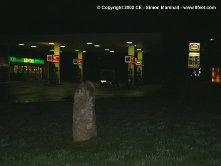
Taken on 4th August 2002 at the end of a day of visting sites in the Cotswolds. With two hours of driving ahead of us we temporarily lost the will to stick to the Esso boycott. Lou bought provisions from the petrol station while I took these photos (William was asleep in the car).

Taken August 1997: This gives you a good idea of the type of terrain that surrounds you when you visit these stones. The scenery was beautiful on the north coast, and there are so few people up there. This really is a part of Scotland that not many people seem to visit. Not a coach party in sight!

Taken August 1997: A shady spot on a scorching hot day. Shame the photo doesn’t show the cup marks, but I was under attack from horseflies when I took it, so I’m just pleased it’s in focus.
We visited this stone, and it’s neighbour, in August 1997 in scorching weather. At both sites we were plagued by savage horseflies, that made the visit less relaxing than we’d hoped for.
The cup marked stone is the first of the two that you get to coming from Kinloch, and it’s on the left-hand side of the road under some tress.
The RCAHMS database has this to say about this site:
“A large, earth-fast boulder 5ft long as far as is exposed and 3ft 10ins broad, bearing on the upper surface 18 cup marks of various depths of which the most distinct, 3ins in diameter and 1in deep, is towards the N. The whole length of the stone is not visible but the markings do not seem to extend to the covered portion.”
I think it was the unusually hot weather that brought the hungry horseflies out, so you’ll probably be alright if you visit when the weather is more Scottish.
We visited this stone (and it’s neighbour) in August 1997 and were attacked by horseflies as soon as we got there. It was like something out a B-movie. We were on my motorbike, so we ended up keeping all our gear on to avoid getting bitten. It was stupidly hot though, so stomping around the heather with our leathers and crash helmets on, we were boiling.
The stone is on the left-hand side of the road coming from Kinloch, and it’s not too tricky to find.
Here’s what the RCAHMS database has to say about the stone:
“An incised stone, 1.9m long and 0.2m deep, found during field investigation. It lies N-S and measures 0.9m across at the N end, tapering to 0.5m at the S.”
“The marks incised upon this stone bear no relationship to known Pictish or Early Christian symbols; they form no cohesive pattern or identifiable shapes.”
Strangely, no mention of horse flies on the database.
We visited Orkney in July 1997, and made straight for Stennes and Brodgar when we arrived. I was immensely moved by Stennes, which must have once been the most significant megalithic site on Orkney, and still is the most beautiful. The vibes the place gave off were only comparable to Calanais on Lewis.
I proposed to Louise at Stennes, because it seemed like the right place to do it. Five years on I want to go back there and see the stones again. Perhaps we’ll make it soon, with our son William and our, as yet, un-born child [Alfie].
I can’t believe how few people have posted information to this part of the Web site. If you’re considering a trip to Orkney, I can say with all honesty that, for me at least, Stennes justified the trip in itself.

Taken August 1997: We liked this photo so much that we’ve hung a huge copy of it in our living room.

Taken August 1997 the day after I proposed to Louise at Stennes.

Taken August 1997, looking north west, this photo shows the Barnhouse Stone, with Maeshowe in the background.

Taken in July 1995 on one of those nasty little disposable cameras.
A panorama of Castlerigg brought to you by the venerable BBC (powered by Java, so no plug-in necessary).
This is an old Web site (superseded by something a lot more ugly and jumbled), but it’s still worth visiting. The pages on Castlerigg include some aerial photos of the circle.

Taken January 1995: I used to live in Cumbria, so we visited Castlerigg a lot. This isn’t a fantastic picture of the site, but it does give an indication of what the weather is usually like up there! It’s a beautiful place though, and well worth a visit, even if you can’t see it for cloud.

Taken May 1995: We were on a walk from Bowness to Penrith, mostly following the Roman route called High Street. We camped overnight by the circle, and it was beautiful. I remember that one of the stones had been damaged by some idiot lighting a fire against it.

Taken Spring 1995: Here is the central stone at Mayburgh, with my good friend Flotsky leaning irreverently against it. The henge is not easy to photograph because it’s so large, with just the one remaining stone.
This page on Kemp Howe contains links to some photos of the circle, including an interesting aerial shot that gives a good idea of how the circle has been buried by the railway.

Taken Spring 1995: This is an amazing site. It’s sad to see a circle in this state, but the size and presence of the stones still left me impressed. As I understand it there are stones buried under the railway embankment. This means that the circle still has the potential to be restored, one day.
This site has a selection of photos of the Nympsfield barrow, a diagrammatical plan of the site and (wackiest of all) Virtual Reality Panoramas. These are fun, but a bit tricky to operate. I felt nauseous after swinging around in circles a few times. You’ll need either a Java compatible browser or the RealVR plug-in to see the panoramas.
Visited 4th August 2002: Not a very magical site, or it certainly wasn’t when we visited. Still, if you like your megaliths to be within walking distance of an ice-cream van, then you’ll love Nympsfield.
We visited on 4th August 2002, and had trouble finding the stone because it was just over the edge of our map!
When we got there we parked at the gate near the stone, under the watchful gaze of a police officer wearing fluorescents. He was directing traffic to some sort of equestrian show on the other side of the road. We half expected to be arrested for trespass, or climbing over a gate without due care and attention, but rather disappointingly he just stood there looking bored.
I don’t think there is a footpath to the stone, but I guess we have the ‘right to roam’ there. I’ll have to read up on this and find out how the Law stands on this sort of thing.
Visited 4th August 2002: When we pulled up at the recommended footpath to Belas Knap (as signposted) it was threatening rain and the light was fading. The accounts posted to this site of treacherous walks to the barrow made us think twice about taking the approved route (Louise is 7 months pregnant, and William is only three).
From the Landranger map we figured that there was an easier footpath to the barrow, so we drove round to the other side. This didn’t take long. Towards the end of this detour we passed some farm buildings, then followed an un-made track to the point where the footpath to Belas Knap starts and the track itself begins to narrow. There are no signs to say that this is a private track, and from the Landranger we inferred that the track is a public right of way.
The footpath started at a point where there is enough space to park one or two cars on the verge without blocking the track, so we parked up and walked from there. Apart from the rain, this worked out really well because the footpath is straight and level. I’d recommend this route to anyone who might have difficulties with the gradient on the approved route.
Sorry that these directions are a bit vague, but I don’t have the map with me to refer back to. If you can get hold of a map, you’ll be able to see where we went (the footpath we took is straight, the other is windy and goes through a forest).

Taken 4th August 2002: The skies opened up when we got out of the car to walk to Belas Knap. We all got soaked, as illustrated by William (he’s not wearing a hat to keep the sun off). In case you’re thinking Belas Knap is much larger than you thought it was, I should mention that William is only three.

Taken 4th August 2002: This is the tump as we saw it, approaching down the footpath from the main road.

Taken 4th August 2002: Looking out of the tump, you can see just how big the cap stones are on the main chamber. It’s really great sitting inside the tump, but you do need a torch if you want to see anything clearly.

Taken 4th August 2002: At the moment there’s a Traveller’s camp next to the Nympsfield barrow. In case you’re wondering, the yellow blue and red object in the background is a little inflateable bouncy castle.
Dolgamfa (pronounced doll-gam-va) is a small site about half a mile to the west of Ysbytty Cynfyn on the other side of the Rheidol Gorge.
The site is usually described (by the learn-ed) as a kerb or ring cairn, and is similar to the Hirnant just up the road.
At Dolgamfa the grading of the stones is very marked. The taller stones may be aligned with another site or celestial object, but if this is the case I can’t identify it. I wonder whether the stones in the circle were intended to be visible rather than buried under the cairn?
You can get to the circle from Ysbytty Cynfyn by crossing over Parson’s Bridge. You can also walk in from the village of Ystumtuen. Both routes are relatively short as the crow flies, but from Ysbytty Cynfyn you have to walk down into the gorge then back up again, which is a bit of a climb.
The footpath is well marked coming from both directions, but the Dolgamfa Circle itself isn’t marked on the footpath signs where they meet the road, so you may find a map re-assuring. Parking is not a problem whichever route you choose, and it might even be possible to get the bus from Aberystwyth if you’re cunning.

Taken 4th August 2002: Detail of the stone showing some of the smaller holes caused by erosion. This reminds me of the Rollright Stones in Oxfordshire.

Taken 4th August 2002: An ‘edge on’ view of the Longstone.

Taken 4th August 2002: This is the barrow viewed from (approximately) the north. The photo is taken from the footpath that runs alongside the hedge.

Taken 4th August 2002: One of the porthole entrances to the barrow, with my foot (in its second appearance on this site) for scale.
Visited 4th August 2002: Windmill Tump (aka Rodmaron Long Barrow) isn’t sign-posted, so you’ll probably need an Ordnance Survey Map to find it. This Neolithic long barrow is south of road between Rodmarton and Cherington.
You can park in a lay-by near the gate (ST934975), then you’ll have to climb over the gate or squeeze through the gap (if you’re thin) to get into the field. From the road there is no signage, but I’ve checked this out with Gloucestershire County Council, and according to them there is public access to the site.
You can clearly see the barrow from the gate, with it’s own fence surrounding it in the field. The path along the side of the field is very well kept and follows the hedge (unmarked on the Landranger) almost all the way to the barrow. There’s one more gate (this time not locked) then you’re there.
Apparently the barrow was crudely excavated in the 19th Century, and the remains of 10 adults and 3 children were found. You can still see the exploratory ditches that were dug.
The barrow has a false entrance and two unusual porthole entrances. I could only find one of these portholes on the north side [or at least that’s what I thought it was], presumably because most of the grass on the barrow is uncut. From photos I’ve seen of the other porthole, it’s quite small.
The chamber that I found is really obvious, and here you can peer in under a very low capstone. My three year old son William could probably have got into the chamber, but I was worried we might not get him out!
The barrow feels remarkably secluded, even though the walk to the road is less than half a mile. Having gone there expecting nothing very special, I was pleasantly surprised. Well worth a visit!

Taken 23rd July 2002: This site has no sign to mark it, so I don’t know what the ‘experts’ think it is. According to the Web site that Riot Gibbon has posted, it’s a Bronze Age barrow, but I’ve heard mumblings that this might not be the case. Does anyone know any more?

Taken 1st August 2002: This has got to be the strangest thing I’ve posted so far. Clearly there’s not much sign of the Great White Mound in this photo, but the Norman keep of the Tower of London stands on it (allegedly). Even close up, I can’t see any trace of the Mound, but this site has been mucked around with so much (post William the Conqueror) that I guess I shouldn’t be surprised.

This photo was taken on 16th June 2002, looking in the direction of Ysbytty Cynfyn. The site is called Dolgamfa (pronounced doll-gam-va) and it’s about half a mile to the west of Ysbytty Cynfyn on the other side of the Rheidol gorge. You can get to it from Ysbytty Cynfyn by crossing over Parson’s Bridge. Dolgamfa is usually described as a kerb cairn, but it works well as a small stone circle.

Taken 20th July 2002: Mitchell’s Fold is on Common Land, so you’re not supposed to drive near it. In practise farm vehicles drive right past it (I was waiting for this one to go through the middle of the circle, but he skirted round it).

Taken 20th July 2002: There was serious rain bearing in on us from the west when I took this. The only view that wasn’t obscured by rain was this one (looking south west).
