I came back to have another look here nearly 4 years on from my initial visit, armed with more information and the benefit of 4 years intensive stone-visiting. Although Canmore describes 3 stones, there is a fourth, at a greater distance from the other 3, but on exactly the same ENE-WSW alignment. The 3 stones lie approximately 7m apart, the ‘outlier’ is 35m away from the most easterly of the 3. Not sure about this – it’s not as large as the 3 in the row, but just looks and feels right. The most easterly in the row does have some possible weathered cup marks on the upper face.


According to Canmore, the four poster measures less than 3m across, and contains 2 recumbent boulders on the SW and NW, and two smaller earth-fast boulders, both broken. The NW stone has 3 cup marks on the upper surface.
And that’s almost exactly what is here. It lies at the SW end of the stone row, and the view up to the NE is quite spectacular.
Revisited this today armed with a bit more information. There are two sites here, the row/alignment, and the remains of a four poster. Both of these contain cup marks.
Another one supplied by George Currie, he mentioned it on the Scotstone list and so I wandered out there today to have a look. It’s definitely a disrupted four poster, though there are several other stones lying nearby – field clearance or part of something else? I’m not sure. George thought he saw a cup mark on one of the stones, but I’m not convinced. Nice little placement though, and ignoring the trees it sits on a little platform just below the summit of the hill.

George Currie discovered this stone on our recent trip to Upper Gaskan – themodernantiquarian.com/site/4228
On the track back downhill, as we were nearing the road junction, he leapt off the track into the trees and began brushing pine needles off a large boulder. We stood, wondering what on earth he was up to. Then -“Aha!” – we all piled in to see what he had found. And there was a cup marked rock – one cup surrounded by a circle of several more. The photo’s aren’t too great as it was dim and dark in there, but George scores again! We think he can smell them....


Taken from the NE arc of the circle, looking across with the central stone lying to the left.

The central stone with 3 of the stones of the southern arc of the circle just visible.
We visited on 9th November – very interesting site, though the trees make it difficult to photograph, and the shade of the trees adds to the problems. Just NE of the site are the remains of 2 small cairns, robbed-out to help build a nearby wall, and largely ruined by foresting machinery. One of the pictures illustrates the southernmore cairn.


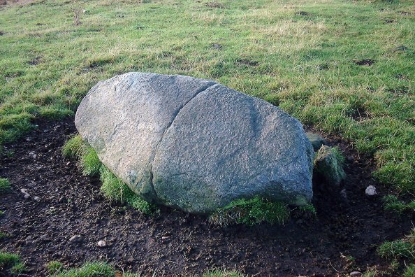
This is not exactly in the place indicated by Canmore, though it is rather difficult to miss. Easily visible from the road, a couple of hundred metres in, a small knoll with a very prominent stone on top. This has several cup marks on it, one being very large. They are all quite weathered.

Moth wonders if a haircut for the stone would reveal the cup marks....
Visited by the Scottish Megaraks on 9th November 2003, as part of a day out. This extremely large stone sits just beside the road, acting as part of a cottage’s garden wall. There are supposed to be cup marks visible on the top, but it was almost completely covered by ivy, so this could not be ascertained.

The remains of the cairn, showing the ditch around it, and the stone lying toppled to the side.


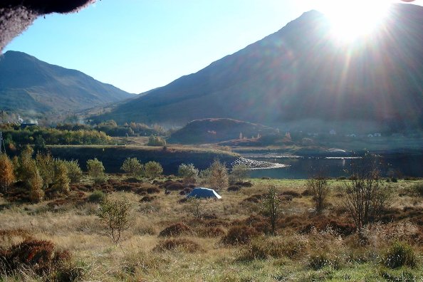
Situated by the side of the road running through Glencoe, according to the board at the Isles of Glencoe Hotel this is an Iron Age hillfort. I didn’t have time to have a good look but took a couple of photographs from a distance – into the sun, so they’re not too great. One to visit next time I’m in the area...
I had a look for this one but couldn’t trace it....
This lies just to the west of the road after crossing the Ballachulish bridge. Best accessed from the side road leading into the village, and following the track down under the bridge and round. Pretty destroyed now, and no sign of either chambering or kerbs, seems to be being used as a field clearance dump as there were a lot of rolls of wire and such like lying around on it. Pretty sad, except for its location – the views along Loch Linnhe are stunning.


Ask permission to visit this at the Golf Club, which lies just beside the wee road leading to Ballachulish House. This cairn is pretty rubbed out, and only a few of the kerb stones survive, but the cist is still in situ, with a slightly dislodged capstone. Apparently when excavated in 1972 no skeletal remains were found, though there was evidence of previous disturbance. Fragments of a food vessel found on the cist floor are in the National Museum of Scottish Antiquities.