
The Knights Templar no longer own the Chapel at Dull, and the (one of many) replica Stone of Destiny has, I believe, been removed to the Aberdeen area. A dig has been taking place there this past week, and as well as many human remains, two cross slabs have been found. One is probably a monk’s grave marker, being inscribed with a simple cross. The other has been dated to the 8th century, and is reasonably intricately carved, showing an Irish influence. A mediaval arrowhead, and a silver groat from the reign of Robert III (1390-1406) and minted at Dumbarton, were also found.
Documentary sources indicate that there was an early monastic settlement here, possibly founded by St Adamnan (Columba’s biographer) who lived 624 to 704 c.e. John of Fordun (1320-1384) suggests that the monks of Dull founded a college, later transferred to St Andrews, and the forerunner of the University there.
The cross mentioned in a previous post was one of four sanctuary crosses. Two others are in the old church at Weem, just down the road. The fourth is now lost.
The field was empty of stock, radioactive sheep or otherwise, when Big Sweetie and I passed on our way back from the dig at Dull church. So we wandered in to have a look. This is one solid chunk of rock, a good 7-1/2 feet tall and four feet wide. No cupmarks visible, though on an earlier excavation I believe seven were found, about a foot below ground. This sits in a fine open plain, and if the rest of the reputed circle were the size of this remaining one, it must have been a pretty impressive sight!


These two articles are from Scottish papers (I think the Courier and Scotsman), didn’t keep a date for them but think they date from circa 2000. Relevant to the right of way:
Judges clear historic path for public
Couple lose fight to block scenic track
JOHN ROBERTSON
Law Correspondent
THE boyhood reminiscences of two pensioners and the legend of Macbeth have helped to establish a public right of way over a disputed mile-long track in the Fife countryside.
For John Wilson and John Davidson, the Bloomfield Walk was more than just a path and yesterday three judges at the Court of Session ruled against a couple living by the ancient route after they tried to bar people from using it. Two of the most important witnesses had been Mr Wilson, 78, and Mr Davidson, 76, who spoke of their childhoods in the village of Newburgh and family strolls and bramble-picking along the track. For Mr Wilson, victory in the long legal dispute came too late. He died last year, but Mr Davidson paid tribute to his friend: “If he was alive he would be having a dram tonight. He wanted me to make sure I walked this path to my dying day.”
For the Stuart kings the path was a royal route from Scone Palace to their hunting lodge at Falkland. Along the way a duel had been fought in 1672 and the Thanes of Fife had claimed it as their own and erected a stone cross in honour of MacDuff, murdered by the usurper Macbeth. Taking in the panorama of Errol, the Carse of Gowrie, Dundee, Perth and the River Tay, the Bloomfield Walk at Newburgh in Fife is one of the most spectacular pathways in Scotland. For Robert and Elizabeth Nisbet, the path was a nuisance. Their house at Bloomfield, by Newburgh, lies near the middle of the route and it was their challenges to people trying to use it that led to Fife Council taking the dispute to court.
In 1997, Sheriff Kevin Breslin ruled at Cupar Sheriff Court that it had been established that a public right of way existed over the route by at least the 1920s and that the right had not been lost by non-use over 20 or more years. He said there was historical evidence that the track had been used for carts and a drover’s road. Also, it had been part of the route from the Tay ferry at Ferryfield of Carpow to Auchtermuchty. By the start of the 20th century, it had been used by pedestrians only and, as at about 1925, Sheriff Breslin added, it was regarded and used as a public right of way by the people of Newburgh. Mr and Mrs Nisbet disputed the judgment and appealed to the Court of Session where the case was heard by Lord Cullen, the Lord Justice-Clerk, sitting with Lords Coulsfield and Caplan.
In yesterday’s judgment, Lord Coulsfield said that the sheriff had relied heavily on the evidence of Mr Wilson and Mr Davidson. Mr Wilson, a retired works manager, lived in Newburgh all his life and told the sheriff that from the age of eight he regularly walked the track with his parents on a Sunday. Mr Davidson, a former maintenance engineer, said he began walking the route aged 11 when he went bramble picking with his father. “His schoolteacher and others at Newburgh had told him that it was a public road,” said Lord Coulsfield. “This was his understanding and his use of the road was never challenged.”
Last night Mr Davidson hailed the court’s decision: “I used to come along here as a boy to pick brambles. The whole stretch used to be covered and it was always a treat to come up and fill our faces. When I heard the Nisbets had started shutting off the track with an iron gate, John and I felt something had to be done. We spoke to the council what seems like ages ago and now it’s been in so many courts I am finally glad it’s over. When I get confirmation in black and white I will be back on the path straight away.” The Nisbets attacked the ruling. When asked for her reaction, Mrs Nisbet ran from her house shouting: “It’s a disgrace, an absolute disgrace.”
------------
The path is famed locally for the Riding of the Marches, a historic walk staged every three years by three hundred locals who finish off by throwing a stick in the River Tay. The walk is set to take place again next year after worries that it might be halted for the first in history. The path runs from a mound of stones called Macduff’s Cross at Newburgh for a mile to the nearby village of Abernethy. John went on: “This one of the most beautiful walks I have ever been on and there’s no way the public should be denied access to what is their birthright. The house the Nisbets live in used to be owned by a lady called Mrs Simpson and when I was a boy sh e would welcome thirsty youngsters and walkers into her home for a strong cup of tea. I can’t see why the Nisbets can’t show the same courtesy.” For John Wilson, the victory came a year too late when he passed on. A regular walker with his good friend John, the pair would meander together along the path and it was his dying wish to see that it remained open.
The judges said that there might have been a very low level of use in modern times, but it was still enough for the route to retain its right of way status. The track runs east from a point on the A913 Newburgh-Abernethy road to the unclassified Newburgh-East Lumbennie road. The mound of stones known as Macduff’s Cross marks the spot which, legend has it, the Thane of Fife passed on his way to Auchtermuchty while fleeing from Macbeth. At another point on the track, there is an ancient relic called Sir Robert’s Prap. It is said to mark the site of a duel in 1672 between two people returning from a fair in Perth.
Robert and Elizabeth Nisbet’s property at Bloomfield, by Newburgh, lies near the middle of the route. It was their challenges to people attemping to use it that led to Fife Council going to court. In 1997, Sheriff Kevin Breslin ruled at Cupar Sheriff Court that it had been established that a public right of way existed over the route by at least the 1920s and that the right had not been lost by non-use over 20 or more years. He said there was historical evidence that the track had been used for carts and a drover’s road. Also, it had been part of the route from the Tay ferry at Ferryfield of Carpow to Auchtermuchty. By the start of the 20th century, it had been used by pedestrians only and as at about 1925, Sheriff Breslin added, it was regarded and used as a public right of way by the people of Newburgh. Mr and Mrs Nisbet disputed there was a public right of way as opposed to a possible estate road, rarely if ever used by the public in modern times. They appealed to the Court of Session where the case was heard by Lord Cullen, the Lord Justice-Clerk, sitting with Lords Coulsfield and Caplan.
In yesterday’s judgment, Lord Coulsfield said the sheriff had relied heavily on the evidence of Mr Wilson and Mr Davidson. However, they were criticised by counsel for Mr and Mrs Nisbet as “shaky witnessses” with unclear and inconsistent accounts.
Mr Wilson, a retired works manager, had lived in Newburgh all his life. He had told the sheriff that at about the age of eight he regularly walked the track with his parents on a Sunday. “He stated that there were always two or three groups of people walking up the road on a Sunday,” said Lord Coulsfield. “Until recent years, when Mr and Mrs Nisbet had attempted to interfere with persons using the route, no challenge had ever been made to the use of the route.”
Mr Davidson, a former maintenance engineer, whose family had long been connected with Newburgh, had said he began walking the route at age 11 when he went bramble picking with his father. “His school teacher and others at Newburgh had told him that it was a public road,” said Lord Coulsfield. “This was his understanding and his use of the road was never challenged...until 1983, when he retired, he would walk it every three or four years.” The appeal judges were satisfied that there had been enough evidence before the sheriff for him to conclude that the route had been used by the public as of right for a long time before the 1920s. Since then, the evidence pointed to a very low level of use. However, Lord Coulsfield said: “There was some evidence of use and, in our view, the sheriff was entitled to conclude that there had never been non-use of the road for a sufficient period for the right of passage along it to be lost.”
theherald.co.uk/news/archive/11-6-19103-23-50-7.html
DULL by name but not by nature.
The sleepy Perthshire hamlet of Dull may be a collection of cottages with an unfortunate name that makes it the butt of many jokes, but an archaeological excavation is uncovering that it was once one of the most important places in Scotland.
The Dull Dig, which will be open to the public from Saturday until June 27, is a rare chance to view an archaeological excavation uncovering aspects of Scotland’s most distant past.
Alan Graham, director of operations at Perthshire Tourist Board, said: “The dig is one of the focal points of Perthshire Archaeology Week, a programme of exhibitions, guided walks, lectures and activities that will highlight the rich and varied history of the heart of Scotland.
“During the week, visitors will be able to sample underwater archaeology, explore one of Europe’s best-preserved Roman forts, walk to Dunsinnan – best known for its association with Macbeth’s castle of Dunsinane – visit a 5000-year-old axe factory, join a landscape survey and much more.”
The area around Dull has been inhabited for at least 5000 years. In the 7th century, it became a place of solitude and retreat for St Adamnan, the biographer of St Columba, who is attributed with halting the plague in the area by the miracle of casting the evil spirits of the disease into a rock.
In the Dark Ages from the 7th century onwards, Dull was the foremost centre of ecclesiastical learning in Scotland with an early Christian monastic complex and a thriving community with paved streets devoted to different trades.
Dull’s influence waned as it was superseded by Dunkeld and St Andrews, but as late as the 12th century it housed a Trionensian priory established by King David I of Scotland.
Now much of the history of Dull is being uncovered through the archaeological dig at Dull parish church, which is thought to occupy the site of the original monastery. Excavations last year uncovered the remains of an earlier building below the church as well as pottery and human remains.
- June 11th 2003


Quite a sad little site this. Follow the sign for the circular walk up the glen, and about 150m in there’s a branch to the left across a wooden bridge. Take the path to the right after the bridge and less than 50m later you pass the outlier. It’s a fair size, around 1.6m in height and 1m across at the base. It stands around 10m from the 3 remaining stones of the circle, all fairly low and half-hidden in the grass. These 3 lie on the NE arc, and the circle probably contained ten stones originally, being around 6m in diameter. 3 stones around the right size and shape lie in or by the burn running alogside, and there is another appropriately sized stone at the foot of the outlier. The whole area’s a bit overgrown and untidy.

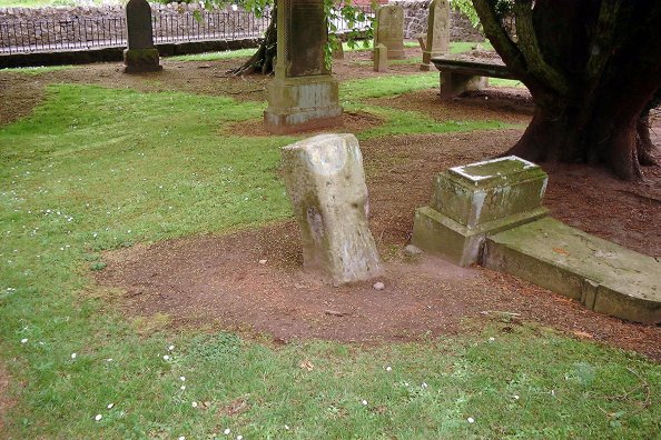
This stone stands in the graveyard at Torphichen Preceptory, a few metres inside the gate towards the left. It is a re-used neolithic stone, which was turned into a marker for the Preceptory. Canmore states “This square sandstone pillar stands 2 1/2’ high, in Torphichen churchyard. It has been shaped, the sides swelling uniformly from the ground to the top, which is 12 1/2” square. There are 5 cup marks and a 6 3/4” long channel on the E face; on the top is a circular socket 2” in diameter and 1 1/2” deep, connected with a cross-shaped channel, 6 1/2” over the arms. The latter features probably have no connections with the cup marks. It is thought to mark the centre of a privileged sanctuary ground attached to the preceptory.” The cup marks are clearly visible.


This stone stands around 1.2m tall, and appears to be sandstone. At some point in the past it has been reinforced by cementing in some field clearance stones around the base. It hasn’t been moved, however, as I saw it marked on a map dating from around 1740, in the position it occupies today. Some pretty good views from where it stands.
There are the remains of an old priory a couple of hundred metres WNW, and another nearby hill is called Temple Hill, apparently the Knights Templar owned the area at some point in the past.
I had a good look round at this location today, and couldn’t identify anything as a stone circle or the remains thereof. The hillside is bracken, and doesn’t look to have been cultivated in a long time. There are a few flat platform areas which might (might!) be ancient housing platforms but I’m not enough of an expert to be sure. There certainly doesn’t appear to be any megaliths left. I did spot a standing stone on West Blair nearby, so I visited it instead.


The Scottish Megaraks visited this area today during a tour of Perthshire. We had a look at the cairn, which according to Canmore was surrounded by kerb stones. Only one was visible, but on pulling back some of the turf and generally nosing around, we discovered that there are still at least eleven in situ. The cairn itself is fairly unremarkable, only being around a metre tall. It is visible from the road if you know what you’re looking for.


This stone is in a field which also contains a long cairn and a circular mound (ringed by a ditch) known locally as Pontius Pilate’s grave. The cup-marks are fairly large, we tried to illustrate them better by applying what remained of our water bottle... without great success.
As can be seen from the photos, the views are well worth the climb. The site had been ‘added to’ by some idiot who had built a small cairn/altar in the centre. This had been removed by the time we left.... (see my last photograph) leaving the original 6-stone site as it is meant to be seen, allowing for the fact that a wall had been built through it in the past!


