


Close up of the notch on top of Long Meg. Can somebody shed some light on the theory that this was cut to be a ‘receptacle’ for the sun?

Carvings mixed with natural viens on the upper-mid section of Long Meg. It could well be that some natural marks were deepened and extended by the carvers.


Lozenge and possible hatching pattern on Stone 3. The carving is close to the edge next to Stone 2


Carved stone to the left, largest stone to the right. Looking roughly in the direction of Long Meg

The carved stone which faces inwards to the circle. Go on Stan, pull the other one!


Welcome to GCHQ Scarborough. Please come in, have a look round, make yourself comfortable.

View from the southeast, partway along Thompson’s Rigg. The shape of the hill from here is almost identical to Howden’s Hill.

From the southwest the hill form is part way between flat top and conical.

Picture taken from The Old Wife’s Way.
From the west Blakey Topping is a classic ‘Close Encounters’ hill.

View of two of the stones from over the fence. The cows were just off to the left – honest!

Seen from the southeast. Howden suddenly pops out at you as you round the corner close to Langdale End.

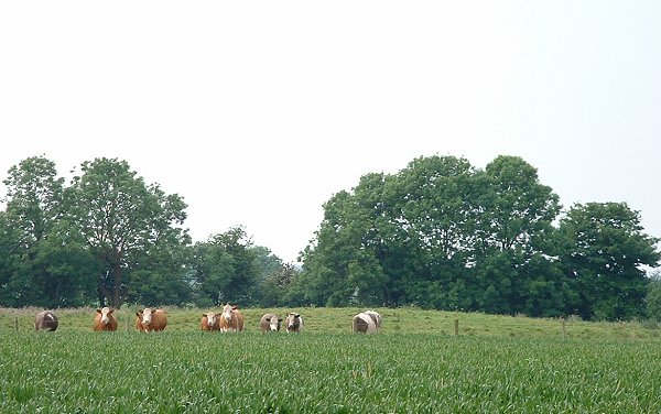
I think they’ve seen me!
The buttermakers at the Butterbumps.

The cows were only small and the ones closest are stood in a slight dip in front of one of the barrows.


The ‘below ground’ part of the trunk. In the middle is the cut away bracket used to tow the tree to it’s resting place. To the left are marks from some of the 50 axes used to shape, de-bark and dress the tree.


Entrance to one of the Bronze Age round houses.
Who lives in a house like this? – me please!

Bronze Age round house. Weaving frame complete with loom weights.


Bronze Age round house. I’m not sure if the chairs are a bit fanciful – I almost expected a little gnome to be sat on one!

Inside the Iron Age round house. It looks a bit sparse – I’m sure there would have been more decoration.

Another view of the trackway. The lines of posts are from (roughly) left to right.

Remains of the Bronze Age trackway. The lines of posts are from the bottom left to top right (following the line of the large timber in the middle and also marked by the info boards attached to the wooden railings).

Southern end of the earthwork hidden in trees. The path shows just how steep and high this Bronze Age bank is


The northern end of the bank looking south – it continues into the trees in the distance.

The northern terminal of the bank. There is a sheer drop down the cliff into the sea behind me!

Castlerigg Plan – Version 1 (cribbed from the information board at the site)
Location, location, location – Castlerigg for me is all about the setting.
The stones sit in a natural amphitheatre of hills that must have impressed the circle’s builders as much as they impress the modern visitor but I always have trouble figuring out which hills are which from just the OS Map – hence this plan.
If anybody spots any mistakes or can add any more information, particularly about where the various sunrises/sunsets occur in relation to the hills please let me know.


Little John in the foreground, Robin Hood just beyond it (according to the OS Map), looking somewhere in the direction of the Roman camp.

The circlular (?) wall of the churchyard is to the right of the picture.

Is the bottom of the larger rock (in sunlight) where the smaller stone was broken off?


I finally re-found this stone although I still don’t know if it has a name – for convenience I’ve decided to call it the Goth Stone (don’t ask!). It is at SE12734625 and stands on the same track that leads southwest across the moor north of Backstone Beck and passes Backstone Circle. It measures 120x110cm and has around 45 cups, a ring and several deep grooves. One of these grooves runs along the line of a natural fault in the stone.
These is another carved stone just to the northwest (I’ve called it the Second Goth Stone)

Second Goth Stone. SE12724628 180x120cm
This stone is to the northwest of the ‘Goth Stone’ (a made up name) and took some finding even though it is not that far from a rarely used track. As the light was getting poor with very little shadow it was difficult to accurately make out all of the designs carved onto its surface but I counted over 30 cups, 3 rings, 6 or more penannulars or unfinished/eroded rings and a couple of possible grooves – although these grooves could be natural.


Stone 3 – the Second Idol Stone. SE12834615
