Excavation Report
baza

The barrow has lost some tarmac and gained a bench since heptangle’s visit

Amongst the large display of artefacts from Hunsbury Hill in Northampton Museum I was astonished to see these Iron Age pottery pieces apparently marked with yin-yang designs.

The unmolestable virgin’s teat peeped at through the nearest roadside hedge

Standing on Ponter’s Ball, looking north towards its crossing of the A361

The 15:10 Glasgow to London Euston Virgin Express passes directly over Kemp Howe stone circle


IronMan is correct in stating that this is off the beaten track; Anglezarke Moor is open access land and there are no continuous footpaths. It can be heavy going on the way here.
In answer to Stroller’s query, and further to Charles’s reply, there’s been no known excavation of Round Loaf. Some flints have been found on the surface over the years. There’s no point in visiting Bolton (or Manchester) museum as they have nothing from local, human prehistory on display whatsoever.


Students from Manchester University excavating test pits near to Fargo Plantation as part of the Stonehenge Riverside Project. Part of the southern bank and ditch of the cursus can be seen just beyond them.
“One of Bodmin Moor’s most attractive and accessible stone circles is to undergo repairs this week.The Trippet Stones stand on Manor Common, between Bodmin and Blisland, just a mile north west of the A30. The circle, which was originally comprised of 27 stones, was erected about 4,000 years ago during the Bronze Age when the moor was densely populated.
Now, just 12 stones remain and of these four are recumbent and eight standing with two of them leaning at an angle of 45 degrees to the ground
Whilst the work is being carried out the public are being invited to visit to learn more about the prehistoric archaeology of Bodmin Moor.
The work, which starts next Monday is the third and final stage in a programme of erosion repair at the Trippet Stones.
Ann Preston-Jones, Cornwall County Council’s field monument warden, said: “A marked feature of the circle is the erosion around the base of each of the stones, a problem arising from a combination factors.
“The soft damp peaty ground, the poor drainage and stock rubbing up against the stones.
“The eroded holes are up to five metres across and 0.6 metres deep. Their large size undoubtedly explains why two of the stones are leaning and others have fallen.”
Archaeologists from the historic environment service will be working alongside North Cornwall District Council’s countryside service and conservation volunteers to fill the deeply worn holes around the base of the standing stones and to set up one stone that fell 25 years ago.
Previous work has seen four of the eroded hollows filled using many tons of stone, earth and turf.
Over the week the four remaining holes will be filled to give those stones greater stability, protect them from further erosion and make them more accessible.
Children from local schools will be given the opportunity to visit the site while the work is taking place and learn about the stone circle and explore the prehistoric environment in which it is set.
The public can attend the site on Tuesday, October 17 and Thursday, October 19 when Tony Blackman of the Cornish Archaeological Society will be on hand to explain the work and introduce visitors to the prehistoric archaeology of the moor.
And if you can’t get along during the day, there will be talks in Blisland and St Breward at 7pm on the evenings of Tuesday October 17 and Wednesday, October 18.
Details are posted in the two villages.”

There are dozens of small stones set within the area shown in this image


This is Paul McCartney’s Standing Stone, situated in a small field just a few yards to the west of the house on his High Park estate on the Mull of Kintyre.
It stands 9 feet 6 inches above the ground, breadth 4 feet 3 inches at the base with thickness of 2 feet tapering to 1 foot 6 inches at its rounded top.
A Neolithic cairn discovered on Lewis could force a controversial wind-farm plan to be redrawn.
Leisure tycoon Nicholas Oppenheim plans to build a 53- turbine wind farm at his Eisgein Estate on the island, but the presence of the cairn could help prove the site was “sacred land” to the prehistoric people who built the famous Callanish standing stones about 12 miles away.
The site lies on a range of hills within the proposed development area known as Cailleach na Mointeach (the Old Woman of the Moors) because the skyline resembles the profile of a woman when viewed from Callanish.
Every 18 and a half years, the Moon rises from her knees – as if being “born” – and then sets at a point framed by the 4,000-year-old stones. Several of the 53 turbines planned by Mr Oppenheim’s Beinn Mhor Power company would interrupt this skyline.
Ian McHardy, an archaeologist, said his discovery of the cairn near the Old Woman’s knees meant the site should be protected. “There’s a five-metre diameter cairn with a curve round the edge of it, which is of typical neolithic construction,” he said.
Mr Oppenheim said: “If there is something, it would be fascinating and the scheme would be amended. But I’d like to hear more about what it is.”
This article: news.scotsman.com/index.cfm?id=1123522006
From The Weston & Somerset Mercury:
A TEAM of archaeologists will begin a four year hunt for hidden treasures on the Mendip Hills soon.
A dozen English Heritage specialists will use the latest aerial scanning technology as well as field surveys and other traditional archaeological techniques to look for new finds.
The project will cost about £100,000 and will end up with an illustrated book of results aimed at a wide audience, as well as technical reports.
English Heritage’s senior archaeological investigator Mark Bowden said: “We are confident that there are rich finds to be had on the Mendips. We know there’s lots of evidence there, it’s an area with huge potential.
“What we learn there will also be of relevance to surrounding lowland areas which were connected to what was going on in the hills. We will be trying to identify previously unrecorded sites and revisit the well known sites with a fresh eye and re-evaluate and interpret what has been discovered in the past.
“We hope to achieve a more complete map of the archaeological remains of the Mendips. We will use aerial photos and ground scans, field surveys, maybe geo-physics and a small amount of excavation and we want to assist local amateur archaeologists by bringing in our own experts and equipment.
“Examples of the things we hope to find include ritual monuments from the prehistoric period like barrows, Priddy Circles and henges.
“A certain number of enclosures have recently been discovered, possibly prehistoric or early medieval. We are hoping we might find more of these banks and ditches or get a clearer idea of how old they are and what their purpose was.”
From 24Hour Museum:
Timbers unearthed during flood defence work on the Norfolk-Suffolk border have been dated to between 3,000 and 4,000 years ago, archaeologists have revealed.
The very well preserved finds are the first of their kind in the region – it is thought they may have belonged to a walkway across the marshland in the Iron Age.
“This is the first such structure to have been discovered within Suffolk and is one of only a few in Britain,” said Jane Sidell, English Heritage Archaeological Science Advisor, “and as such is a nationally important find.” ,,,,continues....
The Stone Circles of Senegambia gain World Heritage status
“The World Heritage Committee sitting at its 30th session in Vilnius, Lithuania, has approved the inscription of the Stone Circles of the Senegambia in the World Heritage List....
The stone circles complex is a trans-border phenomena which extends/radiates from the River Gambia north to the River Saloum in Senegal. In December 2004 the National Council for Arts and Culture spearheaded a workshop which brought together Gambian and Senegalese heritage officials with a view to harmonizing/synchronizing a World Heritage Nomination dossier and developing a management plan for the circles. From the workshop the most representative sites in Gambia (Wassu and Kerbatch) and Senegal (Sine Ngayen and Wanar) were identified for nomination. These are the sites that have now been inscribed in the World Heritage List.”
UNESCO’s brief description of the site
“World Heritage sites belong to all the peoples of the world, irrespective of the territory on which they are located.” – UNESCO

The first example of prehistoric cave art to have been re-discovered in the UK. Engraved on this panel is a stag, looking left. If you can’t make it out amongst the modern graffiti, then check out the black outline in the next photo. Note the vertical lines engraved into the bottom of the panel.


There are four sedimentary layers overlying the stratum containing the footprints


Two sets of human footprints. Those at the top righthand corner head towards the sea; exiting at bottom left is a group coming away from the sea.

Low tide at Formby Point. The sea is a couple of hundred metres out from the prints (in the foreground). Just beyond you can see some tyre tracks. Two Land Rovers drove past and could easily have destroyed the impressions in the less than rock-hard sedimentary layer.
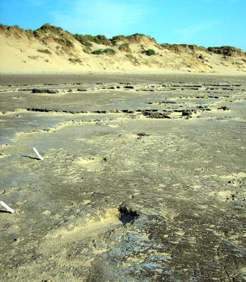
The prints are only twenty metres out from the sand dunes at the top of the beach


The six surviving stones as seen through the window of the glasshouse
Article on the astronomical alignments at megalithic sites in Co. Cork which appeared in Antiquity No. 308 June 2006.

Fencing has recently been erected in the fields at Lyneham long barrow which makes access more difficult. The fencing runs between the barrow and the adjacent standing stone.
Confirmation that this stone is known as “The Murder Stone”.
There may be some confusion with another, much later, stone in the locality:


Nebra Sky Disc Deciphered
“A group of German scientists has deciphered the meaning of one of the most spectacular archeological discoveries in recent years: The mystery-shrouded sky disc of Nebra was used as an advanced astronomical clock.
The purpose of the 3,600 year-old sky disc of Nebra, which caused a world-wide sensation when it was brought to the attention of the German public in 2002, is no longer a matter of speculation.
A group of German scholars who studied this archaeological gem has discovered evidence which suggests that the disc was used as a complex astronomical clock for the harmonization of solar and lunar calendars.”
“Researchers at Newcastle University have found the Thornborough Henges are one of the earliest major monuments aligned to the constellation Orion.
The 5,500-year-old earthworks, north of Ripon, and the Egyptian pyramids are thought to have been built to mirror Orion’s belt for its religious focus.
The research will be published in 2007 in a new report on the henges complex.
Senior lecturer at the university Dr Jan Harding said they used a three dimensional model to confirm the stellar alignments of the henges, which date back to the Neolithic period.”


The Rivington Cup and Ring Stone within its current setting at the Anderton Hall Conference and Training Centre