
The huge capstone on the larger of the two dolmens.
Image credit: Rebecca van der Putt 2004
The huge capstone on the larger of the two dolmens.

Repaired, thankfully, but a tad heavy-handed.

A good spot for burning homework.


A sight to gladden any cromlech-lover’s heart. :o)

The two dolmens under a magnificent oak tree


Beautifully engineered, the uprights support the capstone in such a way as to appear as one single support when viewed from either side. There are in fact two of them.

The inner chamber is very bijou

The capstone shows a skilled stone dresser worked on this chamber

The delicacy of this structure is wonderful


The breathtaking view from this gorgeous little burial chamber


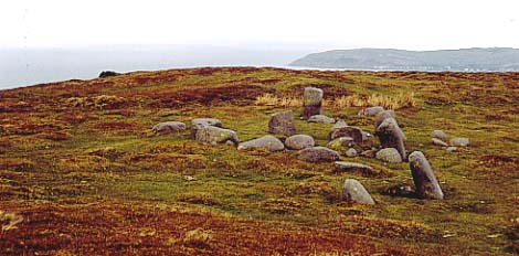
The ‘Jumbled Heap’ or “Cefn Coch Stone Circle” (my suggestion).


Part of the fabulous sacred landscape – looking out to Bae Conwy


Circle 275 looking towards the Druid’s Circle on the horizon.

Bryn Derwydd Standing Stone, looking towards Cefn Maen Amor Stone Circle – the small dark silhouette on the crest of the distant hill.

A shot of one of the useful signboards, with a diagram of how the experts anticipate Old Oswestry would have looked in its hey-day


The Western Entrance, ramparts to the Southern Side. I would not have wanted the task of storming this stronghold.


Some of the phenomenal engineering at Old Oswestry

Small and thriving ponds exist in some of the baffling pits which are unique to Old Oswestry

One of the massive and unsual pits – without a pond
The British Camp has to be one of the first ancient monuments I can remember being taken to see as a child. I have very clear memories of playing with my sister on the side of the ramparts on a hot summer’s day, and can still visualise rolling down the grassy slopes. I think I was pretending to be a medieval archer, as my brain wasn’t able to compute anything much before the 13thC BCE timewise. I do remember feeling that it was an utterly awesome place, and very special. I believe I was about 14 yrs old, and hadn’t yet become obsessed with things megalithic.
I recall wondering why the British camped there when they had the whole of the country to camp in, and wondered how long ago they camped in the place, in what sort of tents, and why would they camp on something with so many banks? Seriously. I was an odd child, but that won’t surprise readers of this site.
Nine years later, I returned for a nostalgic visit, and can well remember approaching the British Camp from the opposite end of the Malverns. I was deeply impressed with it’s size and construction. Through the haze of an August afternoon, in hills covered with banks of rosebay willowherb, the ramparts of this phenomenal fort shimmered into view, huge, impressive, daunting, and glorious at the same time. We didn’t quite make the fort itself on that occasion; but that view on an English summer’s day, with Elgar’s music in my mind (he lived in Great Malvern), will stay with me for the rest of my life.
I’m surprised it hasn’t been covered in fieldnotes before, so do take a day out to visit (probably mid-week, to avoid the crowds), as it is wonderful. Jane, it would be a definite subject for a painting!
What an exquisite place, and an exquisite structure. A definite one to visit, a megarak’s must-see.
I said to the arresting Kate that it was a little gem, and then was put in mind of small iced biscuits. Now, I’ll never be able to eat a purple-topped Iced Gem without thinking of this most divine example of dolmen building.
It is perfectly constructed in every way, and enjoys terrific views over the Conwy Valley. (See weblog for further details).
Go on. Treat yourself this summer. You won’t be disappointed.
This a confusing one. There is a ring cairn which I believe to be Circle 278 just beyond a far more interesting jumble of stones*, which appear to have been moved about somewhat. There is clearly confusion over the name of this mix of stone; please refer to my weblog for a more in-depth discussion.
It’s all very lovely, nonetheless!
*Edit by TMA Ed: the “jumble of stones” is now generally thought to be Monument 280“.
A splendid place. Certainly one to sit and contemplate in for a while, enveloped by the sea, sky, and land which entirely surround the observer on all sides. A large ring, with some significant stones; most spooky being the one that has the form of a white-robed druid.
The location of this circle is intriguing; despite stunning views over Conwy Bay to the north, it has been sited behind a steep mound, thus blocking the view of the sea. Or has the mound been built in front of the circle? There is no doubt that the mound, whatever its origins, is an excellent observation post for anything that might be taking place in the sacred space below.
Also interesting is the proximity of Circle 275 and Circle 278, which flank this larger circle a few hundred yards away on either side. Were they used in conjunction with ceremonies inside the Druid’s Circle?
Small, but perfectly formed. Very endearing, and evidently the smallet circle in the British Isles. I can well believe it. Definitely worth a look when exploring the Penmaenmawr area.
This is clearly an important and impressive site – and the views it commands must be stupendous. On this occasion, we saw it from the Red Farm circle; yet the size of the boulders that form it are huge, gazing down magisterially from their lofty summit, a significant sight for miles around.
Footpaths circle the whole of the mountain. To reach the peak, the footpath crossing the southwestern side is probably the best choice, but it will still necessitate a hearty stroll across the mountaintop on unmarked land.
Blink, and you’ll miss ‘em. Four stones are all that remain of this once proud circle, judging by the survivors. They are in a field not far from Bryn Derwydd farmhouse, so I wouldn’t advise brazen trespassing.
They look quite pretty, nonetheless, and by balancing on rocks at the side of the drystone wall bounding the field, it is possible to have a good look at them as they sit in a graceful curving line.
Especially intriguing is their position in relationship to Cefn Maen Amor circle, which can been seen on the summit of Cefn Maen Amor mountain directly behind them on the eastern horizon . . .
Further along, there is a huge standing stone right outside the farmhouse, the Bryn Derwydd Standing Stone. It’s an impressive erection, and like the remains of Red Farm, looks towards Cefn Maen Amor.
What a corker! This is a huge, overwhelming, complex and thoroughly unusual hillfort. Massive ramparts tower upwards, on the eastern side numbering five banks, but on the west increasing to seven. Even more intriguingly, the western side has five massive pits built into the defences, a construction totally unique in hillfort design.
The history is rich (see weblog for full run-down), the views magnificent, the atmosphere lovely and unspoilt. An absolute must-see for any self-respecting hillfort fan, or those requiring a jolly splendid picnic.
This is a short lump of greyish limestone that points up from the ground at a jaunty angle, probably no more that 2.5-3ft high. Stumpy and solid, it is the smoothest, roundest piece of rock for miles around; everything else is stepped and fissured limestone. It does appear that a few pieces have split or broken away over time, and so it might have stood considerably taller originally. It has the characteristic hollow in the ground on one side where the sheep use it as a leaning/scratching post; and as ever, the views it commands are stupendous.
Clambering up on to the flat, plateau–like top of the fort, we were treated to the most amazing view across Oxfordshire, and what was clearly a very important Iron Age kingdom. To the south-west lay Churn Knob, easily picked out from the copses on the horizon by the bloody great cross erected next to the mound. (Blasted St. Birinus; but it does make a handy reference point – OK, I deserve a smack with a riding crop). Beyond Churn Knob lay the Blewbury Downs Tumuli, almost equidistant between Blewburton Hill and Perborough Castle. The same tribe, maybe, or a shared burial ground?
Looking round to the west, the land spread before us magnificently, leading out to the Vale of White Horse; then we were subjected to the unfortunate and grotesque Didcot Power Station, squatting like a homunculus on this realm; and in the north, Oxford. Further round, clearly and unmistakably, the twin copses of Wittenham Clumps and the Sinodun Hills rose up proudly from the flat fields. A kilometer from them stood the lonely tree on Brightwell Barrow. Looking north-east, we could see what I thought was Stokenchurch Tower, poking up from the edge of the Chilterns. Cloudhigh wondered if he could see Ivinghoe Beacon on the horizon.
And somehow, it suddenly all added up for me, this landscape. The different places flowed together across the land in one continuous line; a line the ancients knew; a line that continues throughout time, just as powerfully on a Sunday afternoon in the second millennium CE as in the first millennium BCE. Blimey, that’s 3,000 years!!!
Sitting at the roof of Oxfordshire, just looking at the land below, the curvature of the earth, and the pattern of the fields became very centering. Time slowed instantly. The warm wind rustled gently through the long grasses. Its whispering was a panacea to my twisted, mangled, exhausted emotions [after the sudden death of my sister’s boyfriend]. Goddess knew how my sister felt; I wished I could pass on some of this spiritual salve.
