
blossom


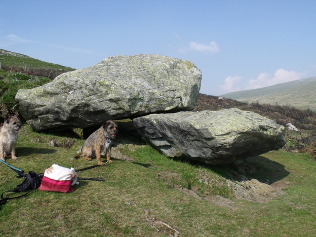
Not the arrow stone but the 2nd stone mentioned by GAT
Image credit: BLOSS

This is not the arrow strone but the 2nd stone mentioned by GAT
Image credit: blossom

Small circular hollow/cup mark? In 2nd stone mentioned by Gwynedd archeological Trust.
Image credit: bloss

image of the mound next to Ty’n Lywyn farm. Poss site of another stone?
Image credit: bloss

Stone in 3rd field. Looking towards the first field
Image credit: bloss


the 2nd stone at pentir with the first in the background
Image credit: blossom

this is the first stone you see when you cross the bridge
Image credit: blossom

From the A5 take the B4366 towards Llanberis after approx 2.6 miles take the right hand turn signposted for Caerhun. There’s a decent pub on the left called the Vaynol that does a nice meal.
Cross over a small stone bridge. Here the road will fork off to the right, don’t follow this but turn left onto Pont Felin which is a single track road. (there was some mad classic car race taking place on these back roads on my last visit).
Approx half mile along this road there is a small stone bridge on the left leading to a field. Park your car (if you are in one) just after this bridge.
Cross over this bridge. The farm gate may be closed but isn’t usually padlocked. The first standing stone can be seen directly infront of you.
The RCAHMW give this ref for this site NPRN
406343
The farm of Ty’n-Llwyn is surrounded by a rough circle or oval setting of 6 standing stones and two mounds. The setting encloses a considerable area of approximately 750m diameter. The discovery of an interrupted ditch enclosure or plough-levelled barrow (NPRN 403377) during RCAHMW aerial reconnaissance in 2005, with a (then unrecorded) standing stone on its summit, gave context to the stone; it seemed as likely to be a prehistoric ritual monument as a modern boundary stone.
A prehistoric date for the remaining stones in this ‘setting’ would be highly unusual given its size. However, their ascription to being modern boundary stones does not explain the occurrence of a mound and a complex barrow within the setting.
There is an aerial photo of this taken by RCAHMW at this web site:
coflein.gov.uk/en/site/403377/images/AP_2005_1627.jpg
.........................................................................
I have visited 2 more of the stones mentioned by Coflien. The next to go and see would be in the field to the right. Follow round the edge of the field next to the woodland. (be aware if you have dogs with you that this is a covert and is full of pheasants)
At the edge of the woodland continue following the field boundary. There will be a gate in the middle of the fence on your right. The next stone can be seen on a mound in the middle of this field.
If you look towards Tyn-llywyn farm you will be able to see another mound. There may be another stone on this mound.
Looking back towards the first stone you can clearly see the mound which that stands upon.
The CBA Wales gives this description of the first mound.
near Pentir, a plough-levelled barrow with a causewayed ditch and partial surrounding palisade was discovered (Figure 2; NPRNs 403376 & 403377). More problematic is the fact that the mound is surmounted by an undated standing stone, which forms part of a wider circle of stones and a levelled mound currently of unknown date, surrounding nearby Ty’n Llwyn farm. More work is needed to ascertain the true date and origins of these features.
And there is a diagram of the features at the following web address:
britarch.ac.uk/cbawales/Newsletters/newsletter30/newsletter30.html
Once you have made your way back to the road turn right after you have crossed over the bridge. After a few metres you will see a gate on the opposite side of the road. You will have to climb this one. Walk around the boundary of the field to the top. The next stone is at the top of the field on the right.
We did find another stone lower down the field but this was surrounded by farm machinary.
I then found that there was an arrow sharpening stone just down the same road at Rhos Fawr. PRN 33 SH56086833 but had no luck in finding it depite my best efforts and with the only outcome being a very sore back, scratches and insect bites.
We found where it should be, but the vegetation was just too dense to have any success.
Would be a great find. But may be one for winter.
G.A.T says of this
Primary Reference Number (PRN) : 33
Trust : Gwynedd
Site Type : ARROW SHARPENING STONE
Period : Unknown
Community : Pentir
NGR : SH56086833
Legal Protection :
Description :
A large boulder with as many as forty-five sharpening marks was discovered during fieldwork along the line of the Pentir Llanfairpwll gas pipeline in June 1976. The incisions were accompanied by an area impressed with small punch marks and patches of deliberate smoothing. The boulder was moved to the side of the pipeline track to avoid further disturbance. A total of 45 V-sectioned incisions were observed.
:................................................................
There is so much going on in this area. Still so much more to find.
Don’t be put off by the blooming great electricity station.

To left of the picture is the mound. This is formed when the heated rocks are removed from the trough so that the trough can be used again.
Just to the right of the centre is a rectangle of rushes. this is where the trough was.
You can see the stream in the front of the image and just behind the rushes you may be able to see the ridge that forms the horseshoe shaped bank.
Image credit: D Williams
Burnt Stone Mound Moel Faban.
There is a typical burnt stone mound beside a stream on the north east of Moel Faban.
The mound is horse shoe shaped, surrounding a rectangular patch of rushes which indicates the position of the boiling trough. The whole is enclosed by a low bank.
This may have been the cooking place for the occupants of the round houses but maybe earlier Bronze age.
Meat was cooked in water brought to the boil by throwing heated stones into the trough.
This is a quote from an artical written by Col. A Lane.
“On the opening of two Cairns near Bangor N, Wales”
“Further to the south stands the curiosly marked stone called “Carreg Saethau” The incised lines upon which are believed to have been made by the old people in sharpening thier metal arrow heads”
The Journal of the Ethological Society of London (1869-1870)
vol 2 (1870) pp 306-324
published by Anthropological Institute of Great Britain and Ireland.
.......................................................................
The Gwynedd archeological Trust have added
There is another stone, which also has the same odd markings, also situated about 3 yards from the stream at SH63336774, commanding excellent views down to Bethesda and across to Anglesey.
I have searched for this stone quite extensively but cannot find it in this location. The only one I could find was a large boulder with another resting on top of it. The markings on these stones all looked natural to me. Apart from a quite deep circular hole, possible cup?
I have taken pics of this.


Previous page201-225 of 225 posts