
Visited: July 1, 2016
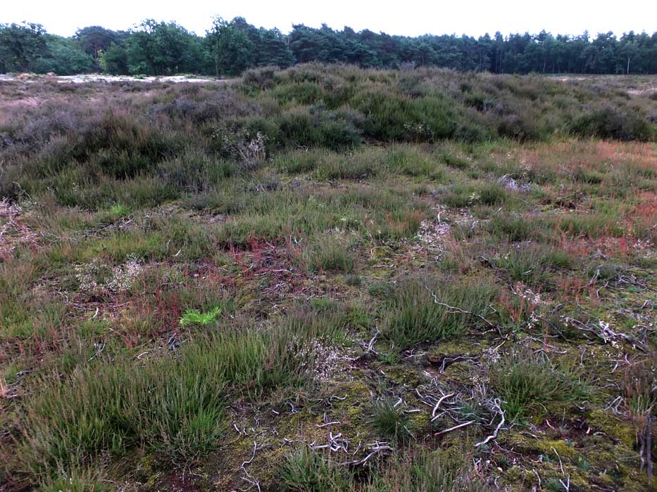
Grave Mound 12 on the Westerheide has, despite a probable height of two metres, an extremely low profile as it rises very gradually. This is the most extensive mound in the heathland, with a width that I estimated to be at least 30 metres.

Hilversum 12, so extensive that it required a composite of three photographs to capture it in its entirety.
Visited: July 1, 2016
Grafheuvel No 11 in the Westerheide is small and inconspicuous. Completely heather covered, it could well be mistaken for a mere undulation in the heathland, rising to about 2 metres and around 10 metres wide.

Visited: July 1, 2016
Westerheide 10 is the most easterly of the grave mounds in this area, and is found on the edge of woodland, 300 metres along the main path north through the reserve and approximately 50 metres to the left.
This is a low, grassy mound, struggling to attain a height of one metre, and rather less than ten metres in width.

Visited: July 1, 2016
Grave Mound No 6 is the most northerly in the Westerheide, and a walk of 1½ kilometres from the starting point beside Mounds No 8/9. It’s a shapely grassy mound that must be close to three metres high and about 14 metres wide, easily seen on approach. Almost the entire approach is on good paths and only the final 50 metres requires a tramp through heather.

Grave Mound No 6 is the most northerly in the Westerheide.


Grave Mound No 4, with Mound 5 in the background.

Grave Mound No 5, with Mound 2 in the background.
Visited: June 17, 2015
This is a tight cluster of four barrows occupying an area of 60 × 50 metres.
Westerheide Mound No 2
The terrain in Westerheide provides excellent walking over short heather and grasses so, if you are confident of your directions, you can simply make straight for the mound. Alternatively, there is a choice of paths that will take you close to it.
On approach, this green grassy mound—the southernmost of the group—stands out well against the heather, and looks rather bigger than it really is because it is perched on a natural rise in the terrain. There is actually a path that traverses it. The barrow is between 2 and 3 metres tall and some 15 metres wide.
Visited: July 1, 2016
Westerheide Mound No 3, the northernmost, is a substantial mound almost 3 metres in height and about 20 metres in width, and a virtual twin of Mound 2. The barrow is between 2 and 3 metres tall and some 18 metres wide.
Westerheide Mound No 4 is a small barrow, barely one metre tall and about 5 metres wide.
Westerheide Mound No5 is another diminuitive barrow, about 1½ metres tall, lying just a handful of metres southwest of No 4. It’s about 5 metres in width.
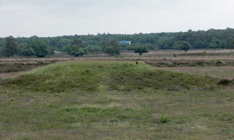
Visited: July 1, 2016
This is a fairly conspicuous Grave Mound, rising from the heath to a height of approximately 2½ metres. Its lower slopes are clad in heather but it has a conspicuous broad, green and grassy summit.
The map shows the walking route from the entrance to the reserve, a distance of 650 metres on good paths followed by a 50 metre walk across short heather.


Grave Mound No 2 is the largest of this group of seven barrows. This composite of two photographs shows the entire mound (with its summit fenced off), which is probably 4 metres tall and well over 20 metres wide.

Grave mounds 1 and 2, which almost overlap, viewed from the north. Mound No 1 is the leftmost of the pair in this view.
Visited: July 1, 2016
Hoornboegse Heide is an area of heathland in het Gooi Nature Reserve, situated on the southern margin of Hilversum, popular with walkers, many exercising their dogs. It is easily accessible by following Utrechtseweg for 1.6 kilometres south of the city then heading to the right along Horneboeglaan. This is a narrow woodland road serving several properties on its south, but after 500 metres the trees to the north peter out and the heath (heide) is revealed.
Almost immediately two huge mounds come into view, Grave Mounds No 1 and No 2, which are so close together that they virtually overlap. The pair are fenced off, but I estimate both to be around four metres high and in the region of 20+ metres wide.
No more than 100 metres to the north, Grave Mounds 3 to 6 stretch in an east-west row. All are smaller heathery mounds roughly 2 metres tall, none exhibiting any noteworthy characteristics.
Finally, another hundred metres or so to the northwest, is Grave Mound No 7. This is wholly unspectacular and, were it not for its surrounding fence, would almost certainly disappear into anonymity as just a low vegetated undulation in the heathland.
The numbering of the mounds follows the maps of the area prepared by Museum ‘Oer’, located in Ulft, Netherlands.

This is the view of Grave Mound No 1 first seen from the path on approaching the Hoorneboegse Heide.

Grave Mound No 2 is the biggest on this site, rising to an impressive 4 metres in height.


Grave Mound No 6 is a fairly inconspicuous heather-covered mound, no more than a metre in height.

Grave Mound No 7 is barely recognisable and could easily be discounted as a mere undulation in the terrain. The fact that it is fenced off is all that gives the game away.

This map indicates the positions of the seven Grafheuvels in the Hoorneboegse Heide, located just south of Hilversum.
Visited: July 1, 2016
De Zeven Bergjes (The Seven Little Hills) is a group of seven round barrows located in the Zuiderheide, a section of het Gooi Nature Reserve located to the northeast of Hilversum. They form a compact grouping, occupying an area measuring approximately 300 × 400 metres.
Three of the barrows (Nos 1, 2 and 7) are sizeable, and probably all in excess of three metres tall; the other four are significantly smaller. None, however, has any striking individuality, and one image only of each is included here.
Nevertheless, this area is easily accessible by a 15 minute walk from the Poolsterstraat bus halt (No 108 bus from Hilversum station), and provides pleasant walking on excellent paths. In a leisurely stroll, I visited all the barrows in three-quarters of an hour.
The grave mounds are about 4,000 years old and date from the Neolithic and the Bronze Age. In and around them have been found urns, a dagger, an axe and a beaker.
The numbering of the mounds follows the maps of the area prepared by Museum ‘Oer’, located in Ulft, Netherlands.

This is an image of Grave Mounds 1 and 2 as viewed from the summit of Mound No 7.

Grave Mound No 1 is probably the largest in this reserve, rising to at least 3 metres above the surrounding terrain. It lies immediately beside the path and presents an attractive green profile, free from the heather that partly masks some of the other barrows.
Grave Mound No 2 is one of the largest in this reserve, a symmetric green dome with a faint path crossing it.

Grave Mound No 3 is one of the smaller ones, rising from the heath as a compact inverted dome with a grassy summit.

Grave Mound No 4 barely reaches 2 metres in height, rising from the heath as a vegetated barrow with a grassy summit.

Grave Mound No 5 is a symmetrical grassy dome, about 2 metres in height, suffering somewhat from erosion.

Grave Mound No 7 is one of the largest, some 3 metres high, and will almost certainly be the first one encountered as you enter the reserve. It stands immediately adjacent to the path that leads to Mounds No 1 and 2. The mound is largely heather-covered, with just a hint of its grassy summit peeking out.

Grave Mound No 6 is one of the less significant of the seven, largely clothed in heather, but with its grassy summit just visible.

Map showing the locations of the Seven Grave Mounds (Zeven Bergjes) in the Zuiderheide to the northeast of Hilversum.

This map of the Westerheide shows the locations of the principal 13 Grave Mounds, and also the multiplicity of paths in the area. The pink markers show the locations and the yellow numbers the rather haphazard numeration of the mounds.
Scale: from north to south the map measures almost exactly one kilometre.
Visited: July 2, 2016
You will almost certainly encounter hunebed D51 Noord Sleen en route to its much better preserved twin, D50, which lies about 100 metres farther along on the opposite side of the road (Hunebedweg).
D51 is very much the poor relation in this hunebed pair: it is somewhat smaller (at 12.3 × 3.5 metres), completely lacks a ring of kerbstones, and has clearly been the target of stone robbers over the ages. All but one of the original 14 sidestones remain in place though, but of the complement of capstones, only two of the assumed seven originals are still to be seen, one still supported and the other partly slumped into the crypt. There is an entrance portal with three of its original four stones still present.


Detail of the sole capstone that still stands on its sidestones.
Visited: July 2, 2016
Hunebed D50 Noord Sleen is in many respects the most spectacular of all the hunebedden, not only for its sheer bulk (it measures 17 metres in length, almost 4.5 metres in width and consists of 16 sidestones and 7 of the original 8 capstones), but because it is surrounded by the most complete set of kerbstones of any hunebed. It is this ring of kerbstones that immediately catches the eye, as many of them are as tall as the sidestones in the hunebed itself, in contrast with the rather diminuitive kerbstones found at other hunebedden.
The circle is also noteworthy for the close packing of its stones which, at several places round the hunebed, stand virtually shoulder to shoulder with each other.
Hunebed D50 possesses just a single remaining stone of its entrance passage. The three missing ones have been marked by concrete slabs by Albert van Giffen.
I first visited here in 2011, and have been waiting for a sunny day to do photographing it justice on several trips to Drenthe since. This seemed to be the day, as I had just visited the Stone of Noordbarge in hot sunshine, but as I took the bus the few kilometres up the road to Noord Sleen, dark clouds gathered. I just had time to take a few photographs of D50 in reasonable light before the rain came, and then I had to beat a hasty retreat as wind and rain lashed the area.
You can read more about Hunebed D50 on Hans Meijer’s website.
This updates the link (below) provided by Jayne, which is now ‘dead’.

This stitched panorama was created from photographs taken with the camera elevated on a monopod, and provides an insight into the amazing ring of 24 kerbstones surrounding the hunebed itself.


This is the view of D50 obtained from the northeast.

This stitched panorama of three photographs emphasises the extent of this enormous hunebed.
Visited: July 2, 2016
I finally got around to visiting this huge erratic boulder after failing miserably, on an earlier trip, to photograph it from the window of a moving bus.
I had been visiting Emmen’s zoo, Wildlands, newly relocated to a spacious park on the western boundary of the town. At the end of the visit, I set out on foot for the Steen van Noordbarge, a pleasant 20-minute walk.
The stone is easily located as it lies on Emmerweg, just a few metres east of the sign indicating the western boundary of Emmen/Noordbarge. It lies in a shallow grassy hollow, and measures 4.15 × 3.40 metres. Efforts had clearly been made in antiquity to shatter the stone for building purposes, as there is evidence of seven boreholes in it.

The Stone of Noordbarge lies immediately adjacent to the sign indicating the western boundary of Emmen.
