


Northwest of the groups of tombs so visible from the access track, and in line with the field boundary, this tomb is just to the right of the path.
A short dromos, into a chamber with a central pillar and a niche opposite the entrance, and then two doors to the right. Climbing through, you’re on a little rocky platform and the ground slopes away towards 4 doors set up from floor level and with a magnificent step to reach the farthest to the left, and a further chamber beyond the second left.
Something about this made me think of the fantastic Hal Saflieni Hypogeum on Malta – but on a much smaller scale of course. I spent what seemed like ages just sat enjoying the cool and the calm and the shafts of sunlight illuminating the entrance.
As in Tomb XVI a twice trepanned skull (image linked) was found here – though this person was not so lucky .... they didn’t survive the second operation.
I couldn’t believe my eyes when I found the plan of this tomb .....
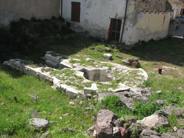
The long dromos or corridor was partly flooded so I’d climbed down into in it where it narrows, and straight in to the main chamber (pictured) with doors at the centre of each of the walls. I’d also noted a chamber to the side of its antichamber, but didn’t realise quite how extensive either part was. Take a look at the plan!
One of the most important tombs at this site, and we didn’t find it. It’s in the area of scrubby vegetation between the very visible tombs such as Tomb VIII and the buildings you pass on the track to get here – hence the grid reference is not absolutely accurate.
It was found still sealed with a slab, and finds included burials from around 2000BCE (though other finds have been noted from the much ealier Ozieri culture) and a twice trepanned skull.

The cart ruts cutting over the dromos of tomb XII with tomb X in the background


This holy well is right in the centre of Perfugas, next to the church. It was discovered in 1923, and named after the owner of the garden it occupies.
The area around has been partly excavated, but it’s the well itself that’s the shining star in white limestone. There’s a passageway and then steps down into the well chamber with its perfectly circular cross section.
It’s fenced off and locked! I enquired at the library on the corner about a key, and was directed to the museum and tourist information .... right at the far end of town on a scorching hot day. When we got there – shut!


We’d been to the village of Rebeccu 18 months previously, just after visiting the nearby domus de janas Sant’ Andrea Priu and not found this, but we had better instructions this time ...
Drive into the village and park in the main square. Exit the main square on foot opposite the way you came in, and follow the path which bends to the right, leaving the village, and Snow White and the 7 Dwarves (no kidding, a full set of gnomes adorn the house on the way) to your right, with open fields falling away to the left. Another path from the village joins from the right, and less than 100m later, there’s a track to the left with a signpost “Fonte”.
The path was being cleared for the summer, and we exchanged greetings with 4 groups of men, scythes in hand but all taking breaks, on the way. About 150m along, there’s a tiny wooden bridge, and the font is up on the right.
An incredibly verdant setting! If not for the grass cutters, we’d have had to wade through chest high greenery to get here!
The Nuraghic font itself is a tholos style chamber; water flows along a groove through the entrance hatch (about 60cm square) in the basalt block frontage and zigzags along the entrance hallway (about 5m long) and drains away under a paving slab at the end.


On the main road, right in the centre of Sedini, the tombs are cut into a massive 12m limestone block. Dated to around 3000BCE, in more recent times it’s been used as a jail, but now houses a museum (apparently – siesta time, all quiet and closed up when we were there).


the bulls head at the back of the elephant, showing the architectural carving too

A slight accidental detour took us through Padria, and in the village we spotted one of the brown signs directing us to an archaelogical area.
Follow the signs – part way along, there’s a huge map at the roadside of areas of interest in the vicinity – and right at the end of the road there’s a gate on the left with a path and steps climbing the hill.
On the plateau, there are nuraghic village huts – hard to work out in the long grass – and the nuraghe itself is to the left behind a tree. It doesn’t look that impressive ..... till you get round the other side!