sals

sals

All posts expand_more 601-650 of 977 posts

Pascaredda

On the SS127 about 5km east of Tempio, and directly opposite a sign “Nuchis 1”, is the signposted turn to Pascaredda. Follow the track over the unmaned railway crossing and keep to the left fork as signposted. About 800m from the main road, there’s a large parking area, but we took the sharp right turn before it, and parked 250m or so further on, just before the riverlet mentioned in TME (OK for small cars, and there’s space to turn round just past the stream).

Free and open access.

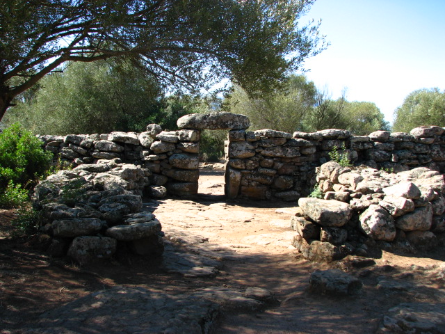
We strolled up the path, with buzzing of thousands of insects filling our ears and butterflies and dragonflies flitting around, over the bridge and to the rear of the tomb.

A stunning spot! The trees are cork oaks and had had their bark stripped for the autumn harvest. Of the stele, only the bottom half is left; the 10 slabs on either side mark out the esedra, and a missing capstone lets you climb into the funeral corridor itself, and the sides of the corridor are buried with the earth bank rather than being exposed stone as we’d seen at other sites.

Again the granite had a pink tinge as we’d seen at Coddu Vecchiu and at the back of the funeral corridor, there’s a shelf, as we’d seen at Li Lolghi.

S'Ena 'e Thomes

There’s a car park off the main road, and a gate on the left leads you to a sandy path, past a fab outcrop of weathered rock ahead, and then to the left to the tomba.

Free and open access – no facilities except parking.

The tomb was restored in the 1970s and is now well preserved. The stele is 3.65 metres tall, and weighs 7 tonnes! The rear of the tomba is surrounded by bushes, but it’s possible (if naughty!) to climb behind the stele to view the funeral corridor – about 11 metres long – and capstones, and indeed climb into the corridor.

A beautiful site – quite a few people wandered past while we were there, but it was never busy. Loads of insect life, particularly praying mantes (mantids, mantises, whichever plural you prefer!) in glorious late afternoon sunshine. There are numerous other bits of rock strewn over the area – Beardy found what appeared to be a cist when we were having a mooch about, aware of two other tombas somewhere nearby but further reading says the area was used from Nuraghic to Roman times and right through to the middle ages.

Oveni

This nuraghe is just south of Serra Orrios and clearly visible from the road.

Even though it’s signposted, it’s behind a high wire fence and the gate is locked – it looks fairly ruinous so maybe is unsafe rather than just closed to visitors.

Motorra

Taking the main road, SS125, north out of Dorgali, you come to a left turn (SP38) signposted to Serra Orrios but keep going on. You need to go another 750 metres along the road – the first bend is sharp, and it’s most of the way round the second bend when there’s a track to the right to the dolmen, with a farm track almost directly opposite it. There’s room to park a couple of cars under a tree opposite the track to the dolmen.

There is a signpost, but it had been knocked or pulled over and was just inside the field – I pulled it over the wire fence and propped it up against the wall, so those travelling south at least would be able to see it.

The track continues for 140 metres, then there’s a fork and a sign directs you to keep left, up a much narrower and quite overgrown path, for another 120 or so metres until the way ahead becomes almost impassable and instead you go through a gate to the left. A series of arrows painted on rocks guide you the last 140 metres to the dolmen itself.

What a stunning spot! A young German-speaking couple were picnicking there, but kindly moved for our cameras.

The dolmen, dated to c 3000BCE, has an almost circular capstone, resting on 7 slabs, and a kerb of stones around it.

Serra Orrios village

The village huts – excavated in 1937 and again in 1947 – number more than 70; most are to the east of temple B, but there’s a distinct cluster to the north too.

The huts – mainly circular single roomed structures, but a few showing two rooms – were built around a series of plazas, two of which have wells. The walls are thick, and storage niches can be seen, along with seats and hearths inside the huts. The pathways between the huts are paved, and each hut has a stone step at its entrance.

Serra Orrios Meeting Temple

The last port of call on the tour is the meeting temple, set apart from the village huts. The finds from excavation in the 1930s were not recorded, but its structure, with a vestibule and interior seating, leads archaeologists to theorise that it was a sacred rather than living space.

Serra Orrios Megaron Temple B

Temple B has a wall surrounding it, with 3 entrances, the middle one of which leads into an ante chamber rather than directly into the temple courtyard.

The temple itself has small vestibule and doorway with a lintel, and both the vestibule and the temple itself have low seating around the interior walls.

Serra Orrios Megaron Temple A

From the gate at the top of the path from the car park, the first area you find is a huge sacred enclosure with the first of the megaron temples – not well preserved.

A doorway in the wall has a foyer area on the outside and takes you on to the rest of the site.

Image of Sardinia (Island) by sals

Sardinia

Island

Map showing the provinces of Sardinia.

The 4 main regions are:

Cagliari
Nuoro
Oristano
Sassari

Four provinces have been created by the Sardinian regional government, but still have to be recognised by the Italian government:

Carbonia-Iglesias
Medio Campidano
Ogliastra
Olbia-Tempio

Image credit: Rarelibra

Serra Orrios

This site is about 9km north west of Dorgali, and is on the SP38. It’s run by the Ghivine Cooperative www.ghivine.com who can arrange guided tours of the archaeology and natural features of the area.

There’s plenty of parking; there’s a cafe – food, drinks, souvenirs, clean toilets – right next door and associated with the site.

Tickets are 6 euros for adults (kids 2½ I think) and it is open 09:00 – 13:00 and 15:00 – 19:00.

From the ticket office it’s about 500 metres to the gate to the site, along a flat paved path.

The site is a nuraghic village, excavated from 1936, but with 3 temple buildings worth listing separately.

Link

Lu Brandali
Lu Brandali and region guide

This pdf is in Italian – 97 pages 1,291KB. It’s one of a series of guides which can be found online in Italian, but are available in a variety of languages to purchase (9 euros each) from the staffed sites in the area.