
L
L-M K

Another view of the north tri-radial cairn.

The north tri-radial cairn.

The west end of the south tri-radial cairn.


Taberg was once a mining area, in the town you will pass a museum if you
follow the site-directions.
taberg.info/engelska/e_gruvan.asp
A good spot to have a coffe break is on the top of the mountain in the town.
Follow the site-directions, but when you have passed the railroad bridge, turn left
after 160 metres, and follow the windling road to the top. There you will find
a restaurant, and a marvellous view over the neighbourhood.
tabergstoppen.se/
(In swedish, but there is an english link at the
bottom of the page)
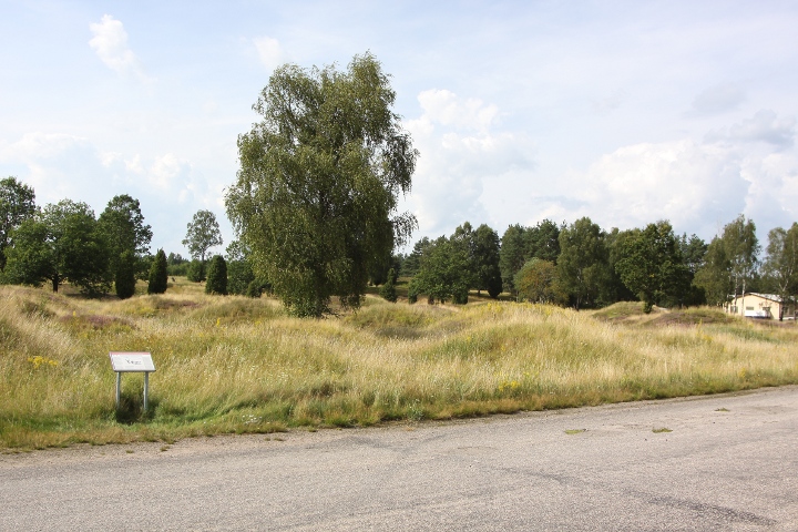
Here on Boeryds gravfält (Grave field of Boeryd), you can find 2 tri-radial cairns, 4 standing stones and 17 stone circles. The tri-radial cairns is 13-20 metres long, and 0,4 high, with the ends pointing at E-SSW-NNW and NE-SSE-WNW. The stone rings are 4-10 metres in diametre, consisting of 5 to 9 stones each. The site was restored in the 1930’s.
Swedish national heritage board site code: Månsarp 25:1. Info board on site with Swedish, English and German. Some of the stone rings can be seen in GE (between the trees).
How to get there:
From highway E4, take the exit at Torsvik N (about 7 kilometres south of Jönköping) and drive westwards to the town Taberg.
In Taberg, turn right in the T-shaped roundabout, drive 300 metres and then turn left and go under the railroad bridge. After 3 kilometres on this road there is a sign “Boerydsgravfältet” pointing to the right, and a few metres into the forest there is a parking sign. Park there and the site is in front of you.

View from the NNE corner.

A closer look at the center-stone.

View towards east, with the west point of the treudd
to the right

One of the barrows close to the road, with a small standing stone on top of it.

View of the site from atop the bronze age cairn 2.

View of the site from atop the bronze age cairn 1.

More standing stones.

The dolmen.

Some standing stones.
View from the old road 2.

View from the old road 1.
Kånna högar (Kånna barrows) is one of Småland’s biggest grave fields. There are almost 300 graves, 230 barrows erected around 500-1000CE. From the older part (500BCE-500CE) there are 2 stone ring , 30 standing stones, 2 treuddar (tri-radial cairns), 15 ring cairns and a dolmen. On the oldest part, from the bronze age (1800-500BCE) there is a cairn.
There is an info board on the site in Swedish, English and German.
The cemetery can clearly be seen in GE (or Google maps)
How to get there:
Drive towards the city Ljungby on highway E4, turn off at the south exit to Ljungby. Drive 700 metres towards Ljungby until the road curves to the left.
There you turn right, and drive for 1 kilmometre. You will see the site to your right, but continue for about 200 metres until you see a sight sign with the word ‘Gravfält’ pointing to the right. Turn right and drive for 250 metres where you will find a parking spot.

To the right in the chamber.

To the left in the chamber.

Inside the chamber.

The entrance.

View from the parking spot: the crop field, with the grave in the center
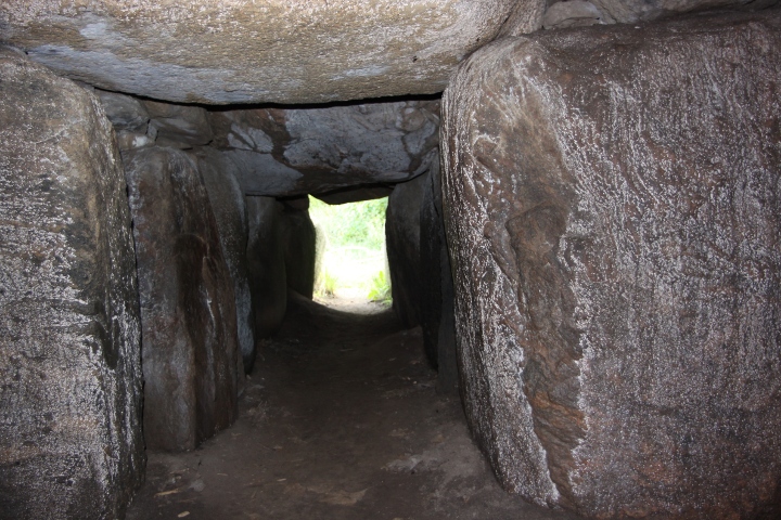
The chamber in this grave is built of 11 stones, and has 3 capstones. The passage consists of 6 stones on each side, and 3 capstones. The entrance width is 0.7 and height 0.6 metres. The length of the passage: 2.7, the chamber length 4.3 and width 2.1 metres.
The passage grave was examined 1843, 1907, 1951 and 1953. Amber pearls, arrow heads, axes, chisels, drills, knives and scraps of flintstone clay pots and the remains of at least 7 people has been found.
About 2 metres east of the passage grave are the remains of a cist, consisting of 4 stones.
The mound can be seen in GE and the passage entrance can just be seen on the ESE edge.
How to get there:
After you have visited the site Glumslövs backar, continue northwards on highway E6 and turn off at the next exit (after 3 kilometres). Turn westwards and turn left in the roundabout after 600 metres. Turn right just when you leave the town Glumslöv (after 3,6 kilometres), and after 3,1 kilometres you will find a parking spot to the right. Park there and the site is in the field northwest of the parking spot.
Note: The site is in the middle of a farmer’s field, on GE you can see a track through the field pointing northwest. When I visited the site, this track didn’t exist, I found one southwest of the site instead, so when you visit the spot, please look carefully around the field and try to find an existing track, to avoid destroying crops.
Complex site consisting of 2 damaged passage graves and 20 barrows. 8 of the barrows are well preserved and can be seen in GE. The barrows are from the early bronze age (2000-2800BCE) One of the biggest barrow is called ‘Viktors hög’ (Viktor’s barrow) and some of the others is called ‘Björne högar’, but none of these names are known to historians, so the barrows are probably named by later inhabitants of the close-by villages. One of the barrows, which in later times were used as an execution place, are called ‘Galgbacken’ (Gallows hill).
Also the passage graves can be seen (the 2 small barrows closest to the highway). Several stones has been blasted away, and the capstones are gone. They have been examined 1842 by professor Sven Nilsson, 1921 by O frödin and crown prince Gustav Adolf. The findings were crashed pottery, miscellaneous flint stone items, stone axes and amber pearls.
They were built around 3600-3200BCE, by the funnel-beaker culture, who was Sweden’s and Denmark’s first farmers.
Sorry for the bad pictures, I (or you?) will try to take some more pictures in the winter, when the grass is down, and the stones more visible.
Info board on site in Swedish, English and German.
How to get there:
The site lies between the cities Landskrona and Helsingborg. It’s easiest if you arrive from the south (suggestion: Visit the site Gillhög first). Drive on the highway E6. When you have travelled 8 kilometres from Landskrona, you will drive up on to a big hill. On the top of the hill, there is a gas station and Burger King, turn at this exit and park the car. The site is immediately south of the gas station.

Some of the barrows on the site.

Another picture of the passage graves.

Remains of one of the passage graves.

One of the barrows.
Gillhög is one of Skåne’s best preserved passage grave. The barrow is about 25 metres in diametre and 2.5 metres high. The passage is 5,5 metres long and 0.5 -1.2 wide. It was examined in 1932 under supervision of Mr. O Rydbäck. They found some skeletons, 1 knife made of flintstone, pearls made of amber, some crashed pottery and miscellaneous tools made of flintstone.
Due to risk of collapsing, Gillhög was restored during 1986 by a team of Danish archaeologists.
This site can also be found in Julian Cope’s book ‘The Megalithic European’ under the name Hofterup, but he also mentions Gillhög in the text.
The compass-reading of the passage is about 121 degrees.
There is an information board on the site with Swedish, English and German info.
How to get there:
The site is situated between the cities Malmö and Landskrona.
Take the highway E6 and turn of the road at the north exit to the town of Löddeköpinge (if you arrive from Landskrona, you will see the shopping centre ‘Center syd’ on the east side of the road immediately before the exit.
Turn westwards toward Barsebäck, drive about 2.4 kilometres. When you are driving upwards a hill, look for a attraction sight sign that points to the left.
Turn left onto the gravel road and drive about 200 metres. turn right and you are at the spot.

Detail of the ‘door stone’, right side.

Detail of the ‘door stone’, left side
The passage.

The right side of the chamber

The left side of the chamber.

The entrance.

Overview of the barrow.
The entrance to the passage grave can be seen to the left.
This burial field was restored in the 1940s. There are 60 graves, of which 38 are stone circles of varying size (the 2 biggest in the pictures). The trident is unusually large, and is probably a cenotaph, a symbolic grave. The site is from early iron age, 500BCE to 500CE.
How to get there
Take the south road (road 132) to Aneby from road 32. When you reach Aneby, turn right, and immediately left, so you drive on a bridge over road 132.
After 7 kilometres, turn left towards Flisby. The site is on the right side after 1 kilometre.
The trident can be seen in GE (or Google maps).

Another stone circle.

One of the stone circles.
According to an info sign at the place, the five stone circles were built in the later iron age (0-500CE).
The name of the site, ‘Smålands stenar’ (the stones of Småland) which by the way has given the nearby town it’s name (Smålandsstenar), was invented by the megalith-interested priest Daniel Nordin in the early 19th century. Before that, the name of the site was ‘Skäppekullen‘
How to get there
The town Smålandsstenar is about 72 kms along road 26 from Halmstad.
Driving northwards, almost when you have exited the town, there is a white sign with black letters ‘Gravfält’ pointing to the right. Turn right and drive about 500 metres, then turn right and drive 250 metres.
The circles can be seen in GE (or google maps).

Map of the site

Another southward view of the site.

Eastward view of the site

Southwards view of the site
The fort lies on the edge of a mountain at the border between the forest and the open plain. Close by, runs the river Järleån, which was an important means of travel.
The fort had natural protection on three sides, with steep, 20 metre deep slopes, and the fourth side was protected by a stone wall. The wall has fallen apart, and looks now more like a bank, but close to the entrance, the wall is better preserved.
Info board on site in Swedish, English and German.
How to get there:
Drive 20 kilometres northward on road 50 from the crossing of highway E20 and road 50.
On the right side you will find a truck parking spot. Park the car there, and immediately north of the parking spot there is a small gravel road to the right. Walk 200 metres and then turn right onto a small track. After about 200 metres you are at the spot.

The trail up to the fort.