Showing 1-50 of 527 posts. Most recent first | Next 50 
A large cup-and-ring marked boulder was found in 2014 during building operations at Birney Hill just south of Darras Hall, an area of proposed housing development surrounding Birney Hall. It was acquired by the Society of Antiquaries of Newcastle upon Tyne in early 2015. The building company whose workers uncovered the stone, Wardell Armstrong, transported it to a site near the south door of the Great North Museum (Hancock) in Newcastle upon Tyne.
The sandstone rock, weighing nearly 3 tonnes, is decorated with distinctive cup and ring symbols. Archaeologists thought that it was unlikely that the rock was originally from that location as it is clearly a part of a much larger rock that had been recut. It is possible that it was brought to Birney Hill from another location as quarried building stone.
Tyne & Wear Museums Blog: http://blog.twmuseums.org.uk/rock-art-from-birney-hill/
Approximate find spot of relocated boulder already assigned location at Hancock Museum: http://www.themodernantiquarian.com/site/17573/birney_hill.html
|

|
Northumberland SMR abstract for Bygate Hill (10236)
(Marginal) A double circle of stones, reported by Mr Surtees to have stood until recently (1827) on Heddon Hill, a mile south west of West Belsay. The inner circle was 60 yards in diameter, and the outer, concentric with it, and from 15 to 20 yards from it. At the centre was a standing stone 10ft high. When Mr Surtees last visited the ground the circles had apparently been levelled, 'the large stone cut into gateposts, and the smaller ones into materials for and adjoining sunk fence'. The view is very extensive especially towards the east. (1)
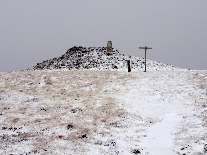
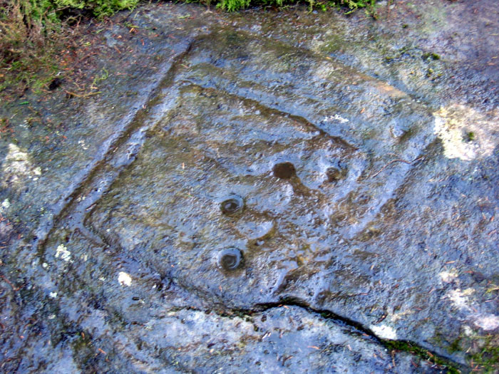
(Marginal) 'Some ancient earthworks and hut circles' on Heddon Hill, now called Bygate Hill. 'These we believe to be the remains referred to by Mr Hodgson, which, if he had seen them himself, he would not have called them concentric circles. As we were accompanied by George Wilkinson, who built the sunk wall to which Mr Hodgson alludes, it is probable that we were on the right spot, indeed, our guide pointed out some holes from which the stones had been taken'. The remains consisted of an enclosure, hexagonal in shape and containing about 2.5 roods. 'The circular parts, which are formed, like the principal enclosure, of earth and stones, are placed together at the north west.... One, more elevated than the rest, has more the appearance of a beacon than a hut circle, and has not escaped the Ordnance Surveyors'. (There is no beacon marked on OS 6! 1865. The trig station at NZ 06817702 is possibly meant). The older inhabitants had no knowledge of the circles described by Hodgson. (2)
Bygate Hill was possibly an early camp. (3)
NZ 06837705. An earth bank, situated on the highest part of Bygate Hill in an all-round commanding position close to the trig station, probably represents the works referred to above. The hill is covered by a dense fir plantation. The bank is visible across a fire-break and can be traced for a few metres into the plantation, but the trees are too dense for a survey to be made. (4)
No trace of the earthworks can now be recognised owing to the density of the plantation. (5)
(1) Hodgson, J.C., 1827. History of Northumberland, part 2, vol.1 (363-4
(2) MacLauchlan, H. 1864. Survey of Eastern Branch of the Watling Street (Newcastle upon Tyne), 8-9
(3) Dodds, M.H. 1926. A History of Northumberland, vol.12 (Newcastle upon Tyne), 13-14
http://ads.ahds.ac.uk/catalogue/collections/nsmr03abstracts/10236.html
|
 
|
Just south-west of the 619m summit of Windy Gyle is the place name "Split the De'il". David Dippie Dixon (Upper Coquetdale, 1903) describes this as an upright rock, some three feet in height. Another contradictory description (1915/16), reported by Rhiannon below, describes an upright slab of porphyry, about 6 feet high, on the southern slope of Windy Gyle, in a south-easterly direction from the cairns.
Pastscape describes it as a prehistoric standing stone at grid reference NT 8563 1502 http://www.pastscape.org.uk/hob.aspx?hob_id=1184023 a location where it is correctly shown on 1:10560 scale maps prior to 1925. However, it appears to have been descheduled (as a scheduled ancient monument) in 1998.
The place name has migrated to the west on modern large scale maps, where it has become associated with the cross border tracks, and the original map position marker (an open circle) which showed at its correct location, removed.
A recent visit http://www.geograph.org.uk/photo/2851698 shows that 3 feet is the more reasonable description of its size, the stone is no longer standing, and probably originally set up as a marker, rather than having a prehistoric origin. The place name though may indicate its former prominence.
A small cluster of other stones around the toppled slab may however indicate that it could have originally been part of a cairn. Many of its stones could have been depleted by the habit of generations of walkers removing stones to place on the greater eminence of Russell's Cairn just to the north. Interestingly, Sir W Aitchison described a Bronze Age burial mound just south of this location in 1951, something that later surveyors couldn't subsequently find http://www.keystothepast.info/durhamcc/K2P.nsf
A medieval cross known to have been set up somewhere in the vicinity, named as Maiden Cross, is discussed here http://canmore.rcahms.gov.uk/en/site/59012/details/maiden+cross/&biblio=more
|

|
|