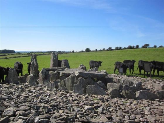
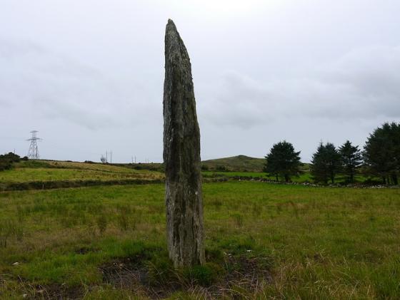
The Modern Antiquarian
Log in
|
Register
Home
Latest Posts
Forums
Maps
Help
Browse Sites
News
Blog
Contributors
The Books
Select
-
Belgium
Denmark
Eire
France
Germany
Greece
Italy
The Netherlands
Norway
Portugal
Republic of Malta
Spain
Sweden
Switzerland
United Kingdom
County Cork
Nursetown Beg
Stone Row / Alignment
Nursetown Beg (Stone Row / Alignment) on The Modern Antiquarian, the UK & Ireland's most popular megalithic community website. 6 images, plus information on many more ancient sites nearby and across the UK & Ireland.
Image © Michael Mitchell
Nearest Town:
Mallow (7km NNE)
OS Ref (IE):
W526924 /
Sheet: 80
Latitude:
52° 4' 53.96" N
Longitude:
8° 41' 29.43" W
Added by
CianMcLiam
Images (6)
0 discussions
Start a topic
Show |
Hide
Web searches for Nursetown Beg
Flickr
Google
Google Images
The Megalithic Portal
Bing
Stone Pages
Wikipedia
Show map
(inline Google Map)
- Sites within 20 km -
-
Carrigcleena (2.12km S) (3 posts)
Bweeng (3.79km SSW) (6 posts)
Garrane (4.86km WSW) (7 posts)
Gneeves (5.6km W) (3 posts)
Glandine (Monkey's Bridge) (5.75km SW) (15 posts)
Ballyknockane (6.11km E) (2 posts)
Knockaroura (6.42km NE) (1 post)
An Seisear (6.53km SW) (14 posts)
Island (7.84km E) (15 posts)
Gowlane North (7.9km SSW) (8 posts)
Kilmartin Lower (12.47km SW) (1 post)
Kilmaclenine (13.32km NNW) (8 posts)
Rylane (13.87km SW) (3 posts)
Rylane (14.13km SW) (5 posts)
Lios na Ratha/Loughane East (14.87km SE) (4 posts)
Loughane East (15.76km SE) (6 posts)
Gortdonaghmore (15.92km SSE) (4 posts)
Oughtihery E (16.45km SW) (9 posts)
Maulmore (16.71km SW) (8 posts)
Oughtihery W (16.93km SW) (9 posts)
Carrigagulla NE (17.58km WSW) (17 posts)
Carrigagulla (17.95km WSW) (20 posts)
Carrigagulla (18.04km WSW) (7 posts)
Carrigagulla NE (18.12km WSW) (10 posts)
Blarney's Dolmen (19.02km SE) (3 posts)
- Add -
-
Add news
Add an image
Add fieldnotes
Add folklore
Add miscellaneous
Add a link
-
Add a site
Add a nearby facility
Add an alternative name/spelling
Images
(click to view fullsize)
Add an image