Image Credit: Environment Agency copyright and/or database right 2015.
Image credit: Open Source Environment Agency LIDAR
Image Credit: Environment Agency copyright and/or database right 2015.
Details of camp on Pastscape
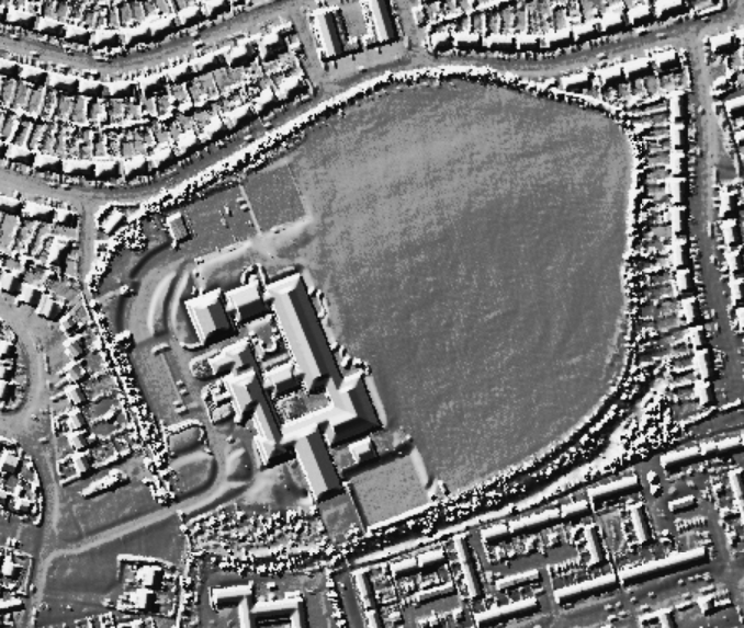
(Area: SU 61355290) Winklebury (Camp) (NR). A much mutilated plateau fort. Where preserved, the bank is 6 feet high, the ditch 40 feet wide and 14 feet deep. No entrances are visible. Samian and “various undetermined local finds” are reported.
EIA’A’ sherds and the base of a deer antler were found by Mrs. Piggott in 1937 during the widening of an entrance cut in the bank of Winklebury. Mrs. Piggott’s finds were made at SU 61315275. The pottery is in Basingstoke Museum. C.H.Read and R.A. Smith found IA sherds and animal bones at Winklebury in the early 1900s.
An IA’A’ plateau-type hill fort, mutilated by ploughing and housing development respectively. The inner slope of the bank is almost ploughed out, a short fragment on the S. is all that remains; the ditch is visible only as a slight depression for much of its length. No original entrances were identified. Sherds found by a Mrs. Winter in the garden of Summerville on the W. side of the work, at SU 61175289, are similar to the 1937 finds displayed at Basingstoke Museum.
Excavations carried out by R. Robertson-Mackay for the M.O.W. revealed a complex defence sequence dating from about the 4th c. to the 1st c. B.C. A close set palisade had later been covered by a rampart and then subsequently enlarged. The ditch yielded evidence of four periods. No major change but housing development has further encroached upon the earthwork along the E side.
Excavation of about 2.0 ha. of the western half of the interior of the hill-fort revealed Iron Age occupation in the form of pits, post-holes, gullies and pottery. The pottery indicated two phases of occupation, the first probably about 6th to 5th century B.C., the second late 2nd century to early 1st century B.C. Structures associated with the first phase included four post-built houses and ten pits, with the second phase semi-circular gullies, many more pits and a large enclosure of at least 4,500 sq.m.
In the first phase the fort was a univallate defended settlement with a single irregular ditch and timber-framed rampart. In the second phase the rampart was modified to a sloping glacis bank with a V-shaped ditch. There was probably a period of abandonment between the two phases.
Well it’s not every child that goes to school inside an Iron Age hillfort (at least not in the present century) – unless you’re at Fort Hill Community School. The fort’s even on their badge along with a nice celticy white horse.


