Skip to content
Julian Cope
presents
The Modern
Antiquarian
Latest
Posts
Sites
Map
Blog
Forum
search
Search
⚠️
Sign in
more_horiz
Eire
County Tipperary
Knigh Hill
Cairn(s)
R858854
expand_more
Nearest town:
Scarriff (2km WSW)
OS reference:
R858854
OS sheet:
59
Latitude:
52° 55' 9.51 N
Longitude:
8° 12' 40.08 W
Added to TMA by
bawn79
Images (3)
Add
content
Images
Depression in the top of the cairn
Image credit: Bawn79
bawn79
Nov 4, 2005
Another view of the Cairn
Image credit: Bawn79
bawn79
Nov 4, 2005
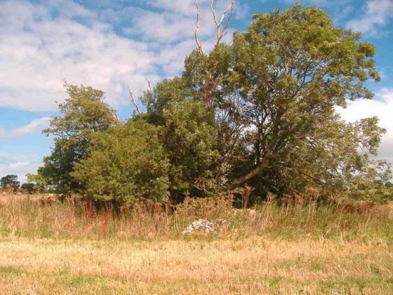
The Cairn
Image credit: Bawn79
bawn79
Nov 4, 2005
Sites within 20km of
Knigh Hill
Ashley Park
Burial Chamber
•
2.26km NE
photo
17
forum
2
description
4
Ashley Park
Wedge Tomb
•
2.38km ENE
photo
2
description
1
Ardcroney
Burial Chamber
•
2.9km NE
photo
5
description
2
Kilruane
Bullaun Stone
•
4.5km E
photo
2
description
1
Whitstone
Cairn(s)
•
5.09km NE
photo
2
description
2
Ardcroney
Portal Tomb
•
5.22km ENE
photo
9
forum
1
description
3
Coolagorane Upper
Cairn(s)
•
5.29km NE
photo
3
description
2
Corravalley
Round Barrow(s)
•
6.4km ENE
photo
3
The Commons of Carney
Cairn(s)
•
6.59km N
photo
2
description
1
Rathurles
Standing Stones
•
6.91km ESE
photo
5
description
1
Rathurles
Rath
•
6.91km ESE
photo
2
description
6
link
1
Youghalvillage
Sacred Well
•
7.04km WSW
photo
3
description
1
Creggane
Wedge Tomb
•
7.09km SW
photo
1
description
1
Rathurles
Rath
•
7.29km ESE
photo
1
description
1
Ballyquinlevan Upper
Bullaun Stone
•
7.64km NNW
photo
2
description
1
Knockalton Lower
Standing Stone / Menhir
•
7.73km SE
photo
1
forum
2
Rathfalla
Henge
•
7.78km ESE
photo
4
forum
1
description
1
Kilcolman
Sacred Well
•
7.86km SW
photo
1
description
1
Tullahedy
Artificial Mound
•
8.09km SSW
photo
1
description
1
Garranmore
Bullaun Stone
•
8.19km WSW
photo
2
description
1
Middlewalk
Round Barrow(s)
•
8.99km E
photo
2
description
1
Cloneygowny
Bullaun Stone
•
9.19km WSW
photo
1
description
1
Townfields
Bullaun Stone
•
10.53km ENE
photo
2
description
1
Lisheentyrone
Standing Stones
•
10.6km WSW
photo
9
forum
1
description
1
Lisheentyrone
Cup Marked Stone
•
10.63km WSW
photo
3
description
1
Lackamore
Wedge Tomb
•
10.89km SW
photo
2
description
1
Carrigeen
Stone Row / Alignment
•
12.23km SW
photo
7
Coumroe
Stone Circle
•
12.49km SW
photo
3
description
1
Burgesbeg
Standing Stones
•
13.13km SW
photo
5
description
1
Burgesbeg
Standing Stone / Menhir
•
13.35km SW
description
1
Gorraun
Wedge Tomb
•
13.47km ENE
photo
5
description
2
Hexenstein – Neerstedt
Cup Marked Stone
•
13.7km W
photo
6
description
2
Knockaunreelyon
Natural Rock Feature
•
13.85km WSW
photo
1
description
1
Laghtea
Hillfort
•
14.24km WSW
photo
1
description
1
Graves of the Leinstermen
Standing Stones
•
14.67km WSW
photo
6
description
4
Dermot and Gráinne’s bed
Wedge Tomb
•
15.5km NNW
Iniscaltra
Christianised Site
•
15.74km WSW
photo
4
link
2
Iniscaltra
Bullaun Stone
•
15.94km WSW
photo
2
description
1
The Bargaining Stone – Inishcealtra
Natural Rock Feature
•
15.95km WSW
photo
2
Ballymalone More
Standing Stone / Menhir
•
16.53km SW
photo
1
description
1
Pestruper Gräberfeld
Megalithic Cemetery
•
16.72km WSW
photo
7
description
1
link
1
Ballinacurra
Cairn(s)
•
16.95km SE
description
1
Ballinlough
Round Barrow(s)
•
17.18km ESE
photo
1
Ballinlough
Standing Stone / Menhir
•
17.18km ESE
photo
2
Bauraglanna
Stone Circle
•
17.19km S
photo
6
description
3
Cooneen
Cairn(s)
•
17.65km SE
photo
7
description
1
Foilnamuck
Wedge Tomb
•
18.06km SSE
photo
9
forum
1
description
1
Cappadine
Standing Stone / Menhir
•
18.11km SW
photo
4
forum
1
description
1
Bohateh North
Chambered Tomb
•
18.67km W
link
1
Foilnamuck
Standing Stone / Menhir
•
18.68km SSE
photo
4
description
1
Ballina
Standing Stone / Menhir
•
18.69km SW
forum
1
description
1
Garruan
Standing Stone / Menhir
•
18.79km SSW
photo
1
Garraun
Round Barrow(s)
•
18.79km SSW
photo
2
description
1
Cooneen
Kerbed Cairn
•
18.92km SSE
photo
2
description
1
Clonalough
Standing Stone / Menhir
•
19.02km SSW
photo
1
description
1
Roolagh
Standing Stones
•
19.57km SW
photo
4
description
1
Killaloe
Standing Stone / Menhir
•
19.76km SW
photo
3
description
1
Ballinahinch
Barrow / Cairn Cemetery
•
19.94km SW
photo
1
Ballinahinch
Barrow / Cairn Cemetery
•
19.99km SW
photo
1
search
I’m looking for…
location_on
photo
ondemand_video
forum
description
link