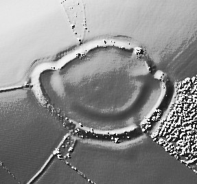
Open Source Environment agency LIDAR
Image credit: © Environment Agency copyright and/or database right 2015.
Open Source Environment agency LIDAR

View of Western inner (Right) and outer (Hedge Line) ramparts of Cadbury Castle taken from the South West footpath entrance.
The Hill Fort is approached via a fairly steep permissive footpath from the South West (Follow road signs from Cadbury Village and park in lay-by) it is worth the walk! The views are breathtaking and offer a 360 degree panorama of other significant sites and much of the lower Exe Valley from Tiverton to Exeter.
From the church we walked up to the Roman encampment of “Cadbury Castle,” which is most interesting. It was partially excavated in 1848, and on the previous evening we had been shown many interesting relics taken from it. The most valuable of these is a large ring of debased silver. On an intaglio of a light green antique paste is engraved an object supposed to be connected with the sacrifices of Apollo or Hercules. There are, besides, some smaller rings, some armlets, reminding one singularly of the present fashionable bangles, and making one remember that there is nothing new under the sun. Both the workmanship and design of these are singularly delicate. There were glass and enamel beads, horses’ teeth, fragments of pottery, &c.
All these had been taken from a well in the centre of the camp. There has been an attempt to fill up this well, but it persistently sinks down in the centre. There is a tradition that there is an underground passage from the top of Cadbury Castle to Dolberry Hill (Killerton). Risdon gives us the following couplet:-
“If Cadbury Castle and Dolberry Hill down delved were,
Then Denshire might plow with a golden coulter and eare with a guilded sheer.”From the same source we learn “that a dragon, forsooth!” is supposed to guard these treasures.
The views from Cadbury Castle are both extensive and beautiful. The Dartmouth Tors were all plainly visible, and we saw Cawsand white with snow. Farther to the left our eyes rested on Exmouth and its Bar, and on the other side we saw the range of hills at Wellington, in Somersetshire.
By ‘Volo non Valeo’ in the Exeter and Plymouth Gazette, 29th May 1885. Tristram Risdon wrote his ‘Survey of the County of Devon’ in 1632.
Details of Cadbury Castle on Pastscape
[SS 91330526] Cadbury Castle [T.I.] Hill Fort [L.B.] Cadbury Castle is an oval-shaped Iron Age (?Promontory) Fort, 640 x 470ft. The defences comprise an outer rampart with escarpment and an inner scarp and counterscarp to the W. S. & E. Entrances are in the N.E. and S.E. A shaft 58ft. deep was excavated by G. Fursdon and the finds included many pottery fragments, some coarse cinerary urn sherds, part of an iron weapon, bronze pins and rings (one possibly 2nd. C.), bronze armillae with gold ornament, charred human bones and a 17th. C. sword. Tucker (a) suggests that some of the pottery may have come from a tumulus close by which had been used to fill up the shaft. A hoard of nine Antoniniani of Victorinus and Tetricus Senior (A.D. 265-272) was found nearby in the hedge of an ancient road leading to the Camp. The Castle was occupied by Fairfax in 1645. (2-4)
This is a hill-top enclosure of two constructional phases. The small internal bank with an entrance on the E. encloses about two acres and is typical of other earthworks in the locality. The enclosure appears to have been enlarged and fortified by the addition of a strong rampart and ditch, with a counterscarp bank on all but the N. side where the existing bank was utilised and strengthened. There is no longer any trace of the depression containing the shaft.Published survey (1/2,500) revised. Finds in the well were recovered from between 20 and 25 below the modern surface, and so had been deposited when the shaft was partly filled. They were mostly personal ornaments, and, though not closely dateable, indicate the 3rd cent. as the most likely date for the deposit. (6) Native cult-centre: shaft containing personal things customary as votive offerings at shrines. (7)
SS 9134 0525. Scheduling revised. Details as above. The site was probably used during the Saxon and medieval period as a moot or open-air court, responsible for the administration and organisation of the countryside. (10)


