
From
archive.org/stream/journalofroyalso3451roya#page/4/mode/2up
The Journal of the Royal Society of Antiquaries of Ireland, v14 5th series, 1904.
Image credit: ?
From
archive.org/stream/journalofroyalso3451roya#page/4/mode/2up
The Journal of the Royal Society of Antiquaries of Ireland, v14 5th series, 1904.

Amongst the large display of artefacts from Hunsbury Hill in Northampton Museum I was astonished to see these Iron Age pottery pieces apparently marked with yin-yang designs.


A rare shot of a recently erected notice board taken before the local troglodyte tribe use it as vitrification material!


A view of the inner sanctum. Spot the rabbit!


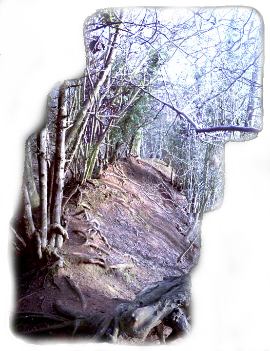
Long since abandoned by man, the surrounding trees are now the modern day gaurdians of the hill fort.

Details of hillfort on Pastscape
[Area centred SP 73805835] HILL FORT [OE] (1)
Hunsbury Hill – An IA Hill Fort, occupied from the 4th cent. BC to the 1st cent BC or AD. Excavations for Iron Stone at the end of the 19th cent yielded great quantities of finds now in the Northants and British Museums. Most of the interior was disturbed by this iron-working, but a small area to the SW remains intact. Fortifications [1936], consist of a single, circular rampart and ditch, with a simple entrance to the SE and possible one in the NW. A second ditch, 80 yds away, was found in 1903. The interior of the fort was riddled with 300 or more pits, of varying sizes – six or seven were walled and one possibly contained a crouched skeleton accompanied by an iron chariot tyre, bridle bit and other pieces of iron. Several unattached skulls were found, one with three holes bored in it. Some 150 querns of the heavy bee-hive type establish a ‘Type Site’ while the quantity of iron objects and slag suggests early iron-stone working. Finds included flint implements, (some barbed and tanged arrowheads), and pottery and other objects of E.I.A. to Roman date. (2-8)
A vast collection of material from Hunsbury is held in Northampton Museum, and incorporates rare objects including the ‘Hunsbury Scabbard’ (which originated the type). The small finds are of both I.A. ‘A’ and ‘B’ cultures, but the latter predominate. Final conclusions indicated an undefended settlement of I.A. ‘A’; later defended in I.A. ‘A’ with defences modified in I.A. ‘B’. Sitting on the Jurassic Ridge it is presumed to have lost its importance as a trading centre in the 1st cent AD. The Hill Fort is now farmed within: it consists of bank, ditch and counterscarp. Iron working has lowered the interior, giving the main rampart a false height. The outer ditch (authy 2b) is not visible, either on the ground or on air cover. Resurveyed at 1/2500. (9)
Hill Fort (SP 738583) usually known as Hunsbury stands on the summit of a rounded but prominent hill, on Northampton Sands, at 110m above OD. The surrounding land slopes only gently in all directions, but the position affords extensive views over Northampton and the whole of the upper Nene Valley to the N, NE and NW as well as to the S and E. (10)
Defences – The fort now consists of a roughly elliptical area 1.6 ha. in area, bounded by an inner rampart and central ditch and with an outer rampart on the NW, N and NE sides. Almost the same picture is recorded by Morton (1712, 537) and by Bridges (1791 I 358). It is possible that there was an outer ditch, and one is mentioned as having been found `in the external ironstone diggings’ in an account of 1891 (Baker 1891-2, 66), though whether this was an external ditch to the fort is not clear; other lengths of ditch were discovered early in this century to the NW and SW of the fort, about 90 yards from the inner ditch (George 1915-18, 3; OS 2 IN map 1901 edn) On an air photgraph (in NMR) are vague cropmarks just outside the fort on its SE unquarried side. These may represent an outer system of ditches. Elsewhere, if they ever existed, they have been entirely removed by ironstone quarrying. The defences have been sectioned three times. The first was in 1880 when a tramway access was cut through the NW side. Dryden (1885-6, 55) made drawings and a brief note on the exposed faces but these only indicate that the ditch was of U-shape and had been cut to a depth of just over 3m into the underlying ironstone and that the inner rampart stood just under 3m above the external ground surface. The other sections were cut in 1952 by R.J.C Atkinson as part of a small excavation on the site. The results have not been published in full and the following account is based on notes made on a lecture given by Atkinson in 1968 (in NM Records). Two trenches were cut across the inner rampart and ditch on the NE and the SE sides at the points where the outer rampart no longer survivies. The NE cutting revealed that the ditch had originally been about 8m deep and that the rampart behind it was timber-laced. The SE cutting was more informative, shwoing that the original ditch had been recut and the timber-laced rampart had been converted into one of glacis construction. This later rampart had been extended over the back of the ealier one and overlay a pit and post-hole which were not excavated. This evidence has been used to suggest that there was originally an undefended settlement on the site but it is clear that the evidence of settlement – the pit and post-hole – only predates the second phase of the rampart, not the first. Two orientated skeletons buried in the second phase of the rampart were discovered but no evidence of date was recovered.
Entrances – There are three entrances through the ramparts and the same certainly existed before the ironstone quarrying commenced. It is no longer possible to be certain whether any of these are original.
The Interior – Within the defences the original land surfaces probably sloped gently down from the SE to the NW. The ironstone quarrying altered this situation completely for the work commenced to the S of the new entrance and `digging nearly up to the edge of the scarp...gradually wheeled round to the north, working from the entrance as a pivot’ (Dryden 1885-6, 55). Between 3m and 5m of material was removed in the operation but, because the ironstone ran out towards the SE, a small area in the SE corner of the interior was left unquarried. Today most of the land within the defences is uneven but the unquarried section is still visible in the SE, its W edge marked by a long scarp up to 2m high. In view of the discoveries made during the quarrying this fragment of the undisturbed interior is of considerable archaeological importance. Considerable amounts of pottery survive, including some fine examples of globular bowls with the distinctive `Hunsbury curvilinear’ decoration. Although the presence of vessels decorated with applied cordons, extensive finger-tipping and incised geometric decoration may indicate activity on the site prior to the later (La Tene) Iron Age, the bulk of the pottery probably dates to no earlier than the 5th century BC. In view of the very small quantity of `early’ material, and its very wide date range, it seems more reasonable to regard it as broadly contemporary with the later Iron Age pottery from the site rather than as indicative of a substantial phase of pre-La Tene occupation. The absence of Belgic material is, in an area with a high density of Belgic sites, also probably of some chronilogical significance. The earliest Belgic wares in this region appear from the later 1st century BC, and the Hunsbury pottery may, therefore, predate the final decades of the 1st century BC, certainly c.AD 25 at latest. (11)
The RCHM Inventory (Authority 11) includes further description of the earthworks, entrances and finds from the hillfort and surrounding area, RCHM plan and earthwork profiles, and a bibliography of 18th, 19th and 20th century sources up to 1976. (12)
Due to the threat of extensive erosion of the rampart on the north side, an excavation was carried out in 1988 on that area. The investigated area was 29m north of the present entrance on the western side of the hillfort.
The rampart was initially of a box type with its individual compartments filled in with marl and sandstone rubble which would have limestone wall also acting as a walkway. There is little doubt that this structure was eventually destroyed by fire. The only pottery and animal bones came from the original ground surface and this limestone wall.
Sandstone blocks spanned a position on a line with the front post revealed during the 1952 excavation. It is possible that posts at the front were set in a stone revetment although no slabs survived in slots.
The position of a series of transverse timbers was indicated by burning, standing stones, and channels of reddish brown loam which had apparently filtered down or tumbled into the voids left by decated timber.
The upper fill of the box rampart probably represents a seperate phase of construction (figs.9 and 10). Eventually the back of the rampart collapsed above the limestone layer. In some places there is evidence for rebuilding of the structure after the burning event. The finds:- 30 sherds only of pottery, all in a shelly fabric with comparable dating for the early-middle Iron Age. (13) (SP 738583). Hunsbury. Listed in gazetteer as a univallate hillfort covering 1.7ha. (14) Additional reference with plan. (15)
I used to live in Northampton. the hillfort was very atmospheric. I believe the skulls with the 3 holes in them were probably supended from a door frame or ceiling beams. It’s a shame the place is heaving with chavs who can make your visit uncomfortable.
I wonder if the forst is in anyway connected to the now vanished Briar hill neolithic causewayed camp which was nearby.
Hunsbury Hill Vitrified Fort by Heptangle
Early last year a new survey to asses the condition of Hunsbury Hill Iron age Fort was undertaken, the results of which now prove that this is no ordinary fort as some might of first thought…
jwaller.co.uk/nas/Hunsbury_Hillfort.htm
According to the new survey, the first ramparts were built between 7,000 – 4,000 BC as a box shaped structure made of wood and supported by further timberwork. The fort was possibly occupied at the time by the Neolithic farmers who tended the surrounding grassland areas.
During the later Iron Age period of between 3,000 – 2,000 BC the fort and the internal banks were rebuilt into a simpler, circular structure of banks and ditches. Some resources, such as the new local council display boards and those at the local museum indicate that the fort was perhaps occupied by a Celtic King or Chieftain, other Nobles, Priests and highly talented craftspeople who were expert in metal crafts, pottery, carpentry & agriculture. The findings of crafts unearthed during previous excavations can be seen on display on the top floor of the Northampton museum. Further information on the latest excavations and various scientific readings of the fort can be found on the Northamptonshire Archaeological Societies web site.
The fascinating conclusion of the survey found that the entire circumference of the internal rampart appears to have been purposely burnt at an intense heat and vitrified during the Iron Age phase. This makes Hunsbury Hill Fort ‘pretty’ unique because many other known vitrified forts like this are found mostly in Scotland.
Sadly the 2004 survey found that the site is not in good condition and the ramparts in the Northern area are very badly eroded. This is mostly down to the resident rabbits burrow damage and allegedly from the roots of the now guardian trees and shrubbery. Although it could also be argued that this may not be the case and that the mighty Oak and Ash trees that grow around the ring in fact actually do an awesome job of protecting the site from severe weather erosion, such as, the battering high winds and torrential rains typical of this area.
Tragically too, many joy ridden abandoned vehicles are vitrified around the park on regular basis, which causes more damage to the already fragile ramparts and surrounding vegetation. However highly effective and dedicated local groups, the local college and the Council have recently done a fantastic job of improving the park in various ways, such as, rebuilding the ancient hedgerows and towing away the molten debris of the frequently burnt automobiles, making the park a much more pleasant environment of late.
One word of warning though! Don’t leave anything of value in your car should you visit the centre, as the entire area is ‘ringed’ by a gang of theives.
I live right by the hillfort and it is a mess – I sometimes ring up to complain about abandoned cars etc.
I use it as a GCSE coursework assignment – what is the purpose of the hillfort? We look at a variety of interpretations dating back to the 19th century. The museum reconstruction is not based on reality at all, as my students discover when they think about the small size of the interior of the fort. You couldn’t possbly get all those huts in!
Because the interior was mined for ironstone in the 19th century, there is no evidence of any inhabitation or post holes. However, the finds, which can be seen in the Central museum, are amazing and raise lots of questions. Why were there huge numbers of quernstones buried in pits? Why was the scabbard bent into 3? Why do the skulls and some pots have 3 holes in them? The previous curator in the education dept thought that the site may have had religious significance as three was a sacred number and iron age people often buried things in the ground as offerings. The quernstones come from far afield – Dorset and Derbyshire. There is evidence of trade and the fort is on an old road (known locally as Green lane).
The ramparts changed shape and this may indicate a change in function (there is a similar change at Rainsborough and at other hillforts such as Danebury).
One day, when I have more time, I want to look into the background to the hillfort in more detail, as it’s a really significant site in terms of finds.
and no-one knows/cares about it sadly. Its a bike track and place to dump old trollies and near which to burn cars. But the main point is that its still here and visible. Well mentioned.
Within Hunsbury Hill country park, to the south of Northampton, are the remains of an Iron Age camp site, this is an elevated site with a high inner bank, a deep ditch and outer bank. The site dates around 1000 – 500 BC.
The Hunsbury Ring Camp would have had an outer perimeter fence encompassing the dwellings which were no more than single room huts made up of timber and straw – normally round in shape. The Chieftain and retinue would have occupied the inner camp with their families whilst the rest farmed small plots in the Local area.
There is a reconstruction model of how it may have looked in use at the Central Museum and Art Gallery in Northampton.


