Skip to content
Julian Cope
presents
The Modern
Antiquarian
Latest
Posts
Sites
Map
Blog
Forum
search
Search
⚠️
Sign in
more_horiz
United Kingdom
Northern Ireland
County Antrim
Carncome
Standing Stone / Menhir
J169962
expand_more
Nearest town:
Moville (70km WNW)
OS reference:
J169962
OS sheets:
9, 14
Latitude:
54° 47' 59.82 N
Longitude:
6° 10' 55.28 W
Added to TMA by
FourWinds
Images (1)
Topics (1)
Add
content
Images
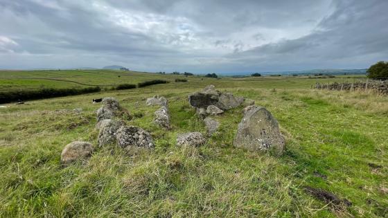
Beyond words what some people are capable of :(
Image credit: Derfel
caealun
Jan 11, 2006
Topics
Carncome
26
Kammer
Dec 2002
Sites within 20km of
Carncome
Tobergill
Stone Circle
•
6.89km ESE
The Witches’ Stone
Bullaun Stone
•
8.64km S
photo
1
description
1
Kilmakee
Cairn(s)
•
12.02km SE
Craigywarren
Standing Stone / Menhir
•
12.64km NW
Craigarogan
Passage Grave
•
15.64km ESE
photo
1
Tamybuck
Wedge Tomb
•
15.75km NE
photo
6
description
1
Antynanum
Standing Stones
•
17.1km NE
Ticloy
Portal Tomb
•
17.62km NNE
photo
5
description
1
The Three Brothers
Stone Row / Alignment
•
18.38km E
Killyglen
Standing Stone / Menhir
•
18.49km ENE
photo
4
forum
1
description
1
Dunteige
Wedge Tomb
•
19.32km NE
photo
5
description
1
Lisnamanny
Standing Stones
•
19.56km NNW
Dunteige
Court Tomb
•
19.59km NE
Like all websites everywhere,
we use
cookies
.
OK
search
I’m looking for…
location_on
photo
ondemand_video
forum
description
link