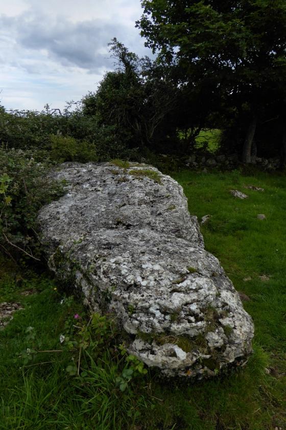


Visited 9.9.12
This is not the easiest of stones to find.
As a CADW site I would expect things to be better sign posted.
Park at the top of the drive leading to Tregwelydd Farm and walk towards the farm buildings. When you get near the farm there is a sign/map showing you the way through the fields to get to the stone. It may be me but I didn’t find this map easy to follow and sure enough it wasn’t too long before I was roaming around the wrong field!
Eventually I spotted the stone and headed for the correct field.
Unfortunately harvesting was taking place and two combined harvesters (where are the Wurzels when you need them?) were doing their thing around the stone.
This made access to the stone unsafe so I settled for a view (which was easy enough) from the edge of the field,
On my way back down the farm drive to the car I noticed that the stone is actually visible across the fields from the drive – to the right if walking away from the farm. If I had noticed this on my way to the site I would have found the stone a lot easier to find.
At least there is no need for sneak visits anymore!
My little boy and me very naughtily sneaked across 3 feilds to see this stone, we ninja scurried and got abit muddy but what an impressive menhir ,despite the obnoxious braces
It’s a bit strange that the stone gets called Maen y Gored (weir) when the house nearby is Maen y Goron (crown). But I think this might at least have the answer as to why the stone was given those awful bands. 45 degrees is pretty gravity defying.
In the parish of Llantrisant, three-quarters of a mile S.W. by S. of the church, and about half a mile north-west of the farm-house of Tregwhelydd, and not far from that of Maen y Goron, is to be found a maen hir, formerly known as MAEN Y GORED; this stone is leaning in a north-westerly direction at an angle of about 45 degrees. Its present measurements are 8 ft. 6 ins. long on its upper surface, 3 ft. 6 ins. in width and from 1 to 2 ft. in thickness. It is composed of mica schist and dolerite which may be local, though there is little dolerite except in ice carried boulders. (E.G.)
No indication of its existence appears on the present Ordnance Surveys but on that of 1841 it is described as “Maen-y-gored”, or the stone of the fish-weir. It is difficult to imagine at the present day where a weir could have existed in its immediate vicinity, possibly a fish-trap, or something of that sort, was to be found in the river Alaw, which is close by.
A second stone lies nearly buried in the ground behind the leaning stone the dimensions of which correspond nearly to those of the first. Excavation might reveal that when in their original upright position they were a pair that stood 11 ft. apart. A block of sandstone, scored by the plough, lies partly under the leaning stone. No orientation can be attempted here. These remains have been placed by Lord Sheffield under the care of the Commissioners for the Preservation of Ancient Monuments.
Coflein’s record is a bit confusing. They have a photo of the stone with its bindings in c1960, but say it was put in them and set in concrete in 1969, so I think there’s a typo. You’d like to hope we weren’t treating stones so cruelly in such recent times.
From ‘The Megalithic Remains of Anglesey’ by E Neil Baynes (1911).


