The Modern Antiquarian. Stone Circles, Ancient Sites, Neolithic Monuments, Ancient Monuments, Prehistoric Sites, Megalithic MysteriesThe Modern Antiquarian


Archsum (Sylt)

<b>Archsum (Sylt)</b>Posted by NucleusImage © Uwe Häberle 09/2020
Latitude:54° 52' 24.78" N
Longitude:   8° 23' 38.98" E

Added by Nucleus


Discussion Topics0 discussions
Start a topic


Show  |  Hide
Web searches for Archsum (Sylt)
Show map   (inline Google Map)

Sites/Regions:

12 posts
Archsum 1 Passage Grave
10 posts
Archsum 2 Dolmen / Quoit / Cromlech
13 posts
Archsum 3 Dolmen / Quoit / Cromlech
7 posts
Archsum 4 Passage Grave
4 posts
Archsum 5 Chambered Tomb (Destroyed)

Images (click to view fullsize)

Add an image Add an image
<b>Archsum (Sylt)</b>Posted by Nucleus

Fieldnotes

Add fieldnotes Add fieldnotes
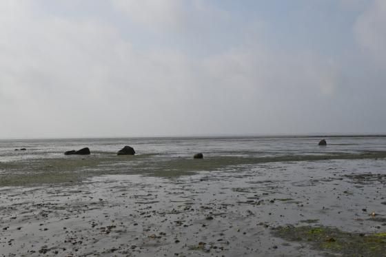
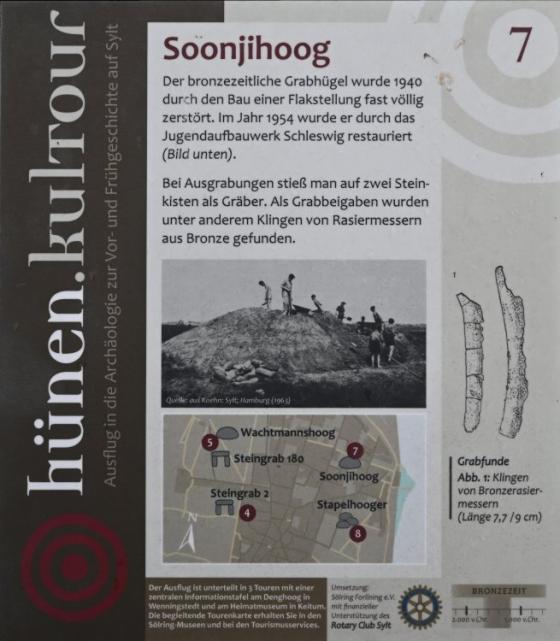
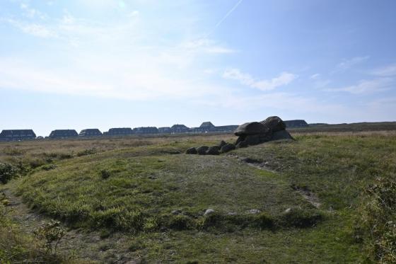
To the south-west of Archsum there are a couple of megalithic tombs, some of which have been destroyed, as they are located in the Wadden Sea and are therefore exposed to ebb and flow. Archsum 1 and the two giant beds Archsum 2 and Archsum 3 are the best preserved of these.

To get to the tombs, turn shortly before leaving the village in the direction of Keitum from the Dorfstrasse in Archsum south into Uaster Reeg. Then turn right into Weesterstich and after 250 m turn left into Deichweg. Follow this road south-west for 1.6km, there is a parking lot immediately in front of the Nössedeich (dike).

Visited September 2020
Nucleus Posted by Nucleus
1st November 2020ce
Edited 1st November 2020ce

Latest posts for Archsum (Sylt)

Showing 1-10 of 46 posts. Most recent first | Next 10

Archsum 5 (Chambered Tomb) — Fieldnotes

taken from the on-site hünen.kulTOUR information boards:

Tjülsekerhoog

The Tjülseker hill is the smallest of the four Sylt Geest cores and rises as a flat knoll over the surrounding marshland. In the middle of the hill lies the Tjülsekerhoog, hidden under a thick layer of humus soil. It contains a destroyed megalithic tomb from the Middle Neolithic.

Later, there was a settlement on Tjülseker that was used for a long time, probably as early as the Roman Iron Age. Findings such as shards, millstones or stone setting indicate this. The settlers increased the elevation by up to 1 m by applying humus. The picture shows the excavation in 1948, with the Nössedeich in the background.

Neolithic period

The neolithic period, the New Stone Age, began on the North Frisian Islands around 4,000 BC and lasted until around 1,800 BC. The permanent settlement of the North Frisian Islands probably began around 3,400 BC. The revolutionary event at the transition to the Neolithic is the change from wandering hunters and gatherers to settled farmers.

The most important material was the flint stone, which was worked with the highest level of skill. This oldest farming culture in the north is called the Funnel Beaker Culture, after a type of clay pot it uses. This culture also built the most impressive evidence of prehistory, the large stone or megalithic tombs.

Settlement in the Neolithic
During the neolithic period, Sylt was partially densely populated on the Geest, presumably divided into individual settlement chambers. The most important area is likely to have been the Kampen-Wenningstedt area, which was probably populated throughout. Since the sea level was then about 3 m lower than it is today, the geest areas populated at that time were significantly higher than today.
Nucleus Posted by Nucleus
22nd November 2020ce

Archsum 5 (Chambered Tomb) — Images (click to view fullsize)

<b>Archsum 5</b>Posted by Nucleus<b>Archsum 5</b>Posted by Nucleus<b>Archsum 5</b>Posted by Nucleus Nucleus Posted by Nucleus
22nd November 2020ce

Archsum 4 (Passage Grave) — Fieldnotes

Kolkingehoog (aka Archsum 4) is a heavily destroyed passage grave. The stones of the grave become visible at low tide, it lies in the tidal flats and is therefore exposed to destruction by the North Sea. The position of the stones has changed a lot due to the constant interference of the sea, and so the original burial chamber can no longer be recognized.

To get to the tomb, turn shortly before leaving the village in the direction of Keitum from the Dorfstrasse in Archsum south into Uaster Reeg. Then turn right into Weesterstich and after 250 m turn left into Deichweg. Follow this road south-west for 1.6 km, there is a parking lot immediately in front of the Nössedeich (Deich means dike). Walk directly over the dike at the parking lot towards the tomb, which lies about 170 m south of the parking lot. A visit at low tide is recommended.

Visited September 2020
Nucleus Posted by Nucleus
14th November 2020ce

Archsum 4 (Passage Grave) — Images

<b>Archsum 4</b>Posted by Nucleus<b>Archsum 4</b>Posted by Nucleus<b>Archsum 4</b>Posted by Nucleus<b>Archsum 4</b>Posted by Nucleus<b>Archsum 4</b>Posted by Nucleus Nucleus Posted by Nucleus
14th November 2020ce
Showing 1-10 of 46 posts. Most recent first | Next 10