Skip to content
Julian Cope
presents
The Modern
Antiquarian
Latest
Posts
Sites
Map
Blog
Forum
search
Search
⚠️
Sign in
more_horiz
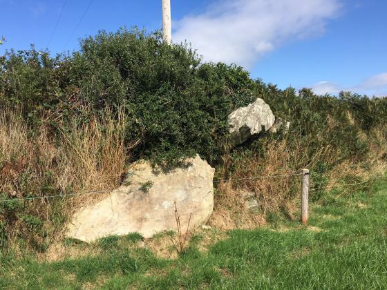
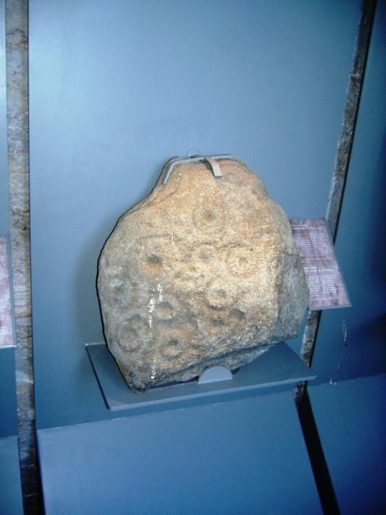
Eire
County Waterford
Whitfield
Standing Stone / Menhir
S540083
expand_more
Also known as:
The Harp Stone
Nearest town:
Waterford (7km NE)
OS reference:
S540083
OS sheets:
75, 76
Latitude:
52° 13' 26.2 N
Longitude:
7° 12' 34.88 W
Added to TMA by
FourWinds
Images (2)
Add
content
Images
Image credit: Bawn79 © 2008
bawn79
May 12, 2008
Image credit: Alan S>
ocifant
Jul 6, 2003
Sites within 20km of
Whitfield
Powersknock
Standing Stone / Menhir
•
1.8km W
photo
1
The Sweep
Standing Stone / Menhir
•
1.8km W
Gaulstown
Portal Tomb
•
2km S
photo
20
forum
2
description
4
Gaulstown Cist
Cist
•
2km S
description
1
Raheens
Standing Stone / Menhir
•
2.94km WSW
Ballymote
Standing Stone / Menhir
•
3.56km S
photo
6
description
1
Ballymote Barrow
Round Barrow(s)
•
3.56km S
description
1
Knockeen
Portal Tomb
•
3.92km E
photo
10
description
2
Lisduggan
Chambered Tomb
•
4.29km E
Ballynaclogh South
Standing Stone / Menhir
•
4.31km SSE
photo
2
Matthewstown
Passage Grave
•
5.5km S
photo
8
forum
1
description
1
Crough
Standing Stones
•
5.62km SW
Carriglong
Passage Grave
•
6.06km E
photo
7
Couse
Chambered Tomb
•
6.19km ENE
Carrickavrantry
Wedge Tomb
•
6.56km SSE
photo
3
description
1
Knockanduff
Wedge Tomb
•
6.58km SSE
Pickardstown
Standing Stone / Menhir
•
6.65km ESE
Ballynageeragh
Portal Tomb
•
6.86km SW
photo
17
forum
1
description
2
Dunhill
Portal Tomb
•
7.02km SSW
photo
10
description
2
Lissahane
Standing Stones
•
8.09km WSW
Savagetown
Standing Stone / Menhir
•
8.35km SW
Castlecraddock
Chambered Tomb
•
8.76km SW
Savagetown
Portal Tomb
•
8.76km SW
photo
3
description
1
Kilbarrymeaden
Bullaun Stone
•
10.04km SW
photo
5
Woodstown
Promontory Fort
•
10.41km SSW
photo
2
Ballyhussa
Standing Stone / Menhir
•
10.96km W
Blenheim Hill
Chambered Tomb
•
11.42km ENE
Ballygunnertemple
Cist
•
11.43km ENE
photo
1
description
1
Whitestown
Chambered Tomb
•
12.71km W
Faithlegg
Bullaun Stone
•
13.91km ENE
photo
3
Harristown
Passage Grave
•
14.12km E
photo
10
description
2
Davidstown
Bullaun Stone
•
14.19km NE
photo
3
forum
1
description
1
Glenaphuca
Standing Stone / Menhir
•
14.56km W
Leckaun
Bullaun Stone
•
14.81km E
Farnoge
Wedge Tomb
•
15.34km NNE
photo
1
description
1
Rathmaiden
Standing Stone / Menhir
•
15.67km W
Ballyquin
Standing Stone / Menhir
•
15.76km WNW
photo
3
description
1
Ballyquin
Standing Stone / Menhir
•
15.95km WNW
photo
2
Ballyquin
Portal Tomb
•
16.01km WNW
photo
10
Croughaun Hill
Cairn(s)
•
16.17km W
Mothel Stone
Cup and Ring Marks / Rock Art
•
16.33km W
photo
3
description
1
link
1
Kealfoun
Standing Stone / Menhir
•
16.75km WSW
Rochestown
Standing Stone / Menhir
•
17.56km NE
Coolnahorna
Bullaun Stone
•
17.62km W
Ballyhenebery
Portal Tomb
•
18.57km NW
photo
4
description
1
Drumlohan
Souterrain
•
18.69km WSW
photo
10
description
2
Ballyvaheen Tomb
Chambered Tomb
•
19.26km N
Ballyvaheen
Standing Stone / Menhir
•
19.6km N
photo
2
search
I’m looking for…
location_on
photo
ondemand_video
forum
description
link