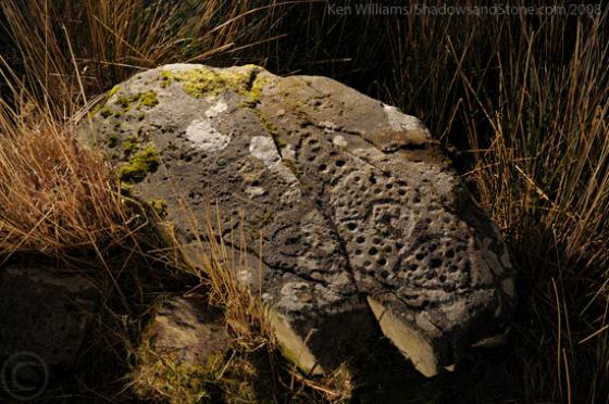
The Modern Antiquarian
Log in
|
Register
Home
Latest Posts
Forums
Maps
Help
Browse Sites
News
Blog
Contributors
The Books
Select
-
Belgium
Denmark
Eire
France
Germany
Greece
Italy
The Netherlands
Norway
Portugal
Republic of Malta
Spain
Sweden
Switzerland
United Kingdom
County Kerry
Derreeny
Derreeny 1
Cup and Ring Marks / Rock Art
Derreeny 1 (Cup and Ring Marks / Rock Art) on The Modern Antiquarian, the UK & Ireland's most popular megalithic community website. 1 image, plus information on many more ancient sites nearby and across the UK & Ireland.
Image © Ken Williams/ShadowsandStone.com 2008
Nearest Town:
Sneem (13km SSW)
OS Ref (IE):
V769775 /
Sheet: 78
Latitude:
51° 56' 10.15" N
Longitude:
9° 47' 24.44" W
Added by
CianMcLiam
Images (1)
0 discussions
Start a topic
Show |
Hide
Web searches for Derreeny 1
Flickr
Google
Google Images
The Megalithic Portal
Bing
Stone Pages
Wikipedia
Show map
(inline Google Map)
- Sites within 20 km -
-
Derreeny 4 (0.14km WNW) (0 posts)
Derreeny 2 (0.14km WNW) (1 post)
Derreeny 3 (0.14km WNW) (1 post)
Derrynablaha F (0.22km WSW) (3 posts)
Derreeny 5 (0.22km NW) (1 post)
Derrynablaha D (0.3km WSW) (2 posts)
Derrynablaha (0.3km WSW) (2 posts)
Derrynablaha 028 (0.4km WSW) (1 post)
Derrynablaha 11 (0.7km WSW) (3 posts)
Derrynablaha 11 (0.8km WSW) (0 posts)
Derrynablaha 7 (0.82km S) (1 post)
Derrynablaha 3 (0.94km SSW) (2 posts)
Derrynablaha 10 (0.94km SSW) (0 posts)
Derrynablaha 6 (1.06km SW) (2 posts)
Derrynablaha 5 (1.06km SW) (4 posts)
Derryleagh (8.34km SW) (3 posts)
Rossacoosane (8.87km E) (1 post)
Tullakeel (9.47km SW) (4 posts)
Dromtine (12.38km SW) (4 posts)
Uragh North (15.23km SE) (14 posts)
Kenmare (15.33km E) (26 posts)
Uragh (15.41km SE) (38 posts)
Uragh West (15.52km SE) (12 posts)
Coomasaharn (15.66km W) (3 posts)
Dromroe (16.23km ESE) (24 posts)
Kealduff (337) (16.73km W) (1 post)
Kealduff (334) (16.73km W) (1 post)
Kealduff (333) (16.79km W) (1 post)
Drombohilly (16.81km SSE) (32 posts)
Kealduff (331) (16.82km W) (4 posts)
Lehid (16.85km SSE) (3 posts)
Lehid (16.87km SSE) (1 post)
Drombohilly Wedge Tomb (17km SSE) (2 posts)
Lehid (17.22km SSE) (2 posts)
Coolnaharagill Upper (18.5km WNW) (2 posts)
Dromatouk (19.01km E) (1 post)
Dromatouk (19.01km E) (3 posts)
Dromatouk (19.13km E) (22 posts)
Dromatouk (19.16km E) (10 posts)
Dromatouk (19.28km E) (8 posts)
Reenkilla (19.77km SSE) (5 posts)
Cashelkeelty SE (19.88km S) (13 posts)
Cashelkeelty NW (19.99km S) (12 posts)
- Add -
-
Add news
Add an image
Add fieldnotes
Add folklore
Add miscellaneous
Add a link
-
Add a site
Add a nearby facility
Add an alternative name/spelling
Images
(click to view fullsize)
Add an image