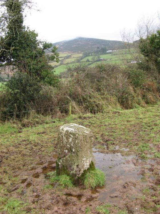
The Modern Antiquarian
Log in
|
Register
Home
Latest Posts
Forums
Maps
Help
Browse Sites
News
Blog
Contributors
The Books
Select
-
Belgium
Denmark
Eire
France
Germany
Greece
Italy
The Netherlands
Norway
Portugal
Republic of Malta
Spain
Sweden
Switzerland
United Kingdom
County Limerick
Coolalough
Standing Stone / Menhir
Coolalough (Standing Stone / Menhir) on The Modern Antiquarian, the UK & Ireland's most popular megalithic community website. 1 image, 1 fieldnote, plus information on many more ancient sites nearby and across the UK & Ireland.
Image © Bawn79 © 2007
Nearest Town:
Hosspital (1km NNW)
OS Ref (IE):
R708347 /
Sheet: 65
Latitude:
52° 27' 47.08" N
Longitude:
8° 25' 46.78" W
Added by
bawn79
Images (1)
Fieldnotes (1)
0 discussions
Start a topic
Show |
Hide
Web searches for Coolalough
Flickr
Google
Google Images
The Megalithic Portal
Bing
Stone Pages
Wikipedia
Show map
(inline Google Map)
- Sites within 20 km -
-
Gotoon (0.5km WNW) (2 posts)
Coolalough (1.12km NNE) (2 posts)
Rathanny (1.43km WSW) (7 posts)
Coolalough (1.65km ENE) (5 posts)
Hospital (2.06km NNE) (2 posts)
Gorteennacreeagh (2.15km W) (2 posts)
Castlefarm (3.1km NW) (4 posts)
Lodge (3.12km N) (4 posts)
Cnoc Aine (3.57km W) (6 posts)
Cnoc Aine (3.66km W) (7 posts)
Ballynamona (4.01km NW) (4 posts)
Cnoc Aine (4.15km W) (3 posts)
Elton (4.15km SSW) (6 posts)
Cnoc Aine (4.16km W) (1 post)
Cloghaunainey (4.32km WNW) (1 post)
Cnoc Aine (4.46km W) (2 posts)
Cromwell Hill (4.73km NNE) (7 posts)
Ballinvana (4.88km SSW) (2 posts)
Clogher Hill (4.98km ESE) (2 posts)
Cloonyconry More (5.45km ENE) (4 posts)
Ballinscaula (5.87km SW) (6 posts)
Ballinscaula (5.87km SW) (2 posts)
Knockroe (6.85km NNE) (1 post)
Grillagh (6.91km W) (0 posts)
Rootiagh (7.05km NNW) (1 post)
Rootiagh (7.24km NW) (3 posts)
Bulgadenhall (7.28km WSW) (1 post)
Moohane (7.39km WNW) (4 posts)
Loughgur (7.76km WNW) (0 posts)
Knockroe (7.87km NW) (3 posts)
Carrignacaubeen (8.09km SSE) (2 posts)
Bruff (8.16km W) (3 posts)
Carraig Aille (8.19km WNW) (7 posts)
Carraig Aille (8.19km WNW) (4 posts)
Lissard (8.46km ESE) (10 posts)
Lough Gur P (8.46km WNW) (1 post)
Tynacocka (8.47km WSW) (2 posts)
Lough Gur O (8.52km WNW) (8 posts)
Black Sow’s Bed (8.55km WNW) (6 posts)
Knockadoon Circles A + B (8.68km WNW) (1 post)
Lissard (8.68km ESE) (3 posts)
Knockadoon (8.75km WNW) (1 post)
Glenbane (8.8km ENE) (1 post)
Knockadoon Circle K (8.82km WNW) (5 posts)
Old Hags Chair (8.89km WNW) (2 posts)
Ballyfroota (8.94km SE) (3 posts)
Entrance to Tir Na Og (9.03km WNW) (3 posts)
Cush (9.04km S) (5 posts)
Cush (9.1km S) (1 post)
Grange / Lios, Lough Gur (9.24km WNW) (87 posts)
Lough Gur Wedge Tomb (9.24km WNW) (26 posts)
Sarsfields Rock (9.3km NE) (3 posts)
Lough Gur C (9.31km WNW) (17 posts)
Lough Gur D (9.31km WNW) (6 posts)
The Stone Of The Tree (9.39km WNW) (6 posts)
Knockfennel (9.46km WNW) (3 posts)
Duntryleague Cairn (9.47km ESE) (1 post)
Duntryleague (9.47km ESE) (32 posts)
Knockfennel (9.53km WNW) (2 posts)
Grange Lios (9.53km WNW) (9 posts)
Ballingarry (9.55km SE) (1 post)
The Pillar Stone (9.56km WNW) (8 posts)
Knockfennel (9.6km WNW) (4 posts)
Cloghast (9.61km SSE) (5 posts)
Knockfennel North (9.66km WNW) (4 posts)
Ballingarry (9.73km SE) (3 posts)
Longstone (9.94km ENE) (8 posts)
Longstone (9.94km ENE) (3 posts)
Longstone (9.94km ENE) (1 post)
Ballyriggin (10.22km S) (2 posts)
Ballingoola A (10.22km WNW) (2 posts)
Rockbarton (10.36km W) (3 posts)
Ballingoola B (10.36km WNW) (1 post)
Lattin (10.36km ENE) (3 posts)
Ballingoola (10.46km WNW) (1 post)
Ballingoola C (10.52km WNW) (1 post)
Ballingoola D (10.76km WNW) (0 posts)
Ballyriggin (10.76km S) (3 posts)
Cnoc Greine (10.81km NNE) (3 posts)
Lattin (10.88km ENE) (3 posts)
Longstone (10.89km N) (2 posts)
Ballingoola E (10.92km WNW) (1 post)
Kilfinnane (11.07km S) (4 posts)
Carraigapuckaun (11.2km SSE) (2 posts)
Knocsefin (11.37km NNE) (3 posts)
Ballyconry (11.67km ENE) (6 posts)
Ballyconry (11.77km ENE) (2 posts)
Knocktwo (12.07km WSW) (3 posts)
Kilfinnane (12.16km S) (2 posts)
Knocksefin (12.23km NNE) (1 post)
Ladys Well (12.37km S) (3 posts)
Ballygeagoge (12.6km SSW) (1 post)
Corderry (12.73km E) (8 posts)
Ballybricken West (13.08km NW) (3 posts)
Ballygeagoge (13.17km SSW) (0 posts)
Liseen (13.18km NNE) (3 posts)
Ballybricken East (13.28km NW) (2 posts)
Ballinculloo (13.34km WSW) (4 posts)
Ballybricken East (13.42km NW) (4 posts)
Ballygeagoge (13.48km SSW) (1 post)
Ballybricken East (13.5km NW) (3 posts)
Mortlestown Hill (13.58km SSW) (5 posts)
Ballinlyna Lower (13.61km S) (1 post)
Brufea (13.96km NW) (3 posts)
Knockroe (14km NW) (7 posts)
Knockroe (14.01km NW) (2 posts)
Shrough (14.06km E) (16 posts)
Knockroe (14.07km NW) (2 posts)
Luddenmore (14.46km NW) (3 posts)
Luddenmore (14.46km NW) (5 posts)
Inch (14.76km NW) (5 posts)
Stonepark (14.88km NW) (2 posts)
Inch St. Lawrence (14.9km NW) (7 posts)
Rathmore South (15.22km W) (3 posts)
Knockeen (15.49km NNW) (1 post)
Ardpatrick (15.53km SSW) (5 posts)
Knocksouna (15.7km WSW) (1 post)
Baunteen (15.77km ESE) (3 posts)
Baunteen (15.86km ESE) (1 post)
Ballynilard (15.94km ENE) (4 posts)
Skahard (16.08km NW) (3 posts)
Clonpet (16.14km E) (1 post)
Tuogh (16.21km NNE) (0 posts)
Darragh Graveyard (16.48km S) (3 posts)
Highpark (16.64km NW) (3 posts)
Highpark (16.66km NW) (1 post)
Highpark (16.74km NW) (4 posts)
Highpark (16.76km NW) (2 posts)
Springfield (17.53km ENE) (2 posts)
Seefin Hill (17.62km SSW) (5 posts)
Labbamologga Middle (17.84km SE) (4 posts)
Labbamologga Middle (17.84km SE) (3 posts)
Labbamologga Middle (17.93km SE) (2 posts)
Temple Hill (17.99km ESE) (6 posts)
Gortavoher (18.08km E) (1 post)
Rock an Tarbh (18.23km E) (3 posts)
Mountrussel (18.41km SSW) (2 posts)
Bawnacouma (18.56km WNW) (1 post)
Castlegale (18.72km SSE) (3 posts)
Castlegale (18.72km SSE) (2 posts)
Friarstown (18.82km WNW) (6 posts)
Gortavoher (North) (18.83km E) (4 posts)
Tory Hill (19.22km W) (2 posts)
Rathneaveen (19.43km ENE) (2 posts)
Rathneaveen (19.51km ENE) (2 posts)
Rearnadargh (19.64km S) (2 posts)
Derrylahan Hill (19.64km SE) (2 posts)
Kilmoylan Upper (19.68km NE) (3 posts)
- Add -
-
Add news
Add an image
Add fieldnotes
Add folklore
Add miscellaneous
Add a link
-
Add a site
Add a nearby facility
Add an alternative name/spelling
Images
(click to view fullsize)
Add an image
Fieldnotes
Add fieldnotes
This stone is not marked on the OS map. It is about 500mm high. It could possibly be a scratching post. However with the quantity of monuments in the area I doubt it.
Comments (0)
|
Add a comment
|
Permalink
Posted by
bawn79
4th July 2007ce