site plan taken from Landesamt für Denkmalpflege und Archäologie
(State Office for Preservation and Archeology)
Image credit: Uwe Häberle 03/2019
site plan taken from Landesamt für Denkmalpflege und Archäologie
(State Office for Preservation and Archeology)

Visited March 2019

Visited March 2019

Visited March 2019

Visited March 2019

Visited March 2019

Visited March 2019
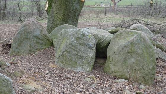
Lüdelsen 3 is a grand dolmen and is located on a southern slope. Before the excavations began, only two capstones and two supporting stones as well as a mound of about 10 m diameter were visible. The tomb is oriented west-northwest-east-southeast.
The excavation revealed that the mound was built in two phases. The diameter of the second, larger mound could be determined to be about 30 m. Likewise, it was possible to identify two enclosures that consist of at least two circles of stones. The inner one could be clearly reconstructed. It consists of 10-40 cm field stones, which were placed in two to three layers on top of each other. The inner mound ends at the first enclosure. An outer row of larger stones is only partially preserved. Their original form is unclear.
In the area of the chamber more supporting stones came to light during the excavation. The chamber measures 4.2 m by 2.6 m on the outside and consists of seven supporting stones on which two capstones rest. Two additional support stones in the east form the entrance, which bends to the north.
The tomb lies only 40 meters north from the parking lot, left of the forest path.
Visited March 2019
taken from the “Archäologisch-historischer Wanderweg Lüdelsen (2)” information board:
Megalithic tomb Lüdelsen site 3
Construction: Funnel Beaker Culture (around 3550 BC);
Burials: Funnel Beaker Culture 3550-3200 BC;
Secondary burials: Single-Grave culture (2400 BC)
The construction of this site with burial chamber, a double or three-row stone embankment and the first mound was around 3550 BC. The chamber construction (inner height approx. 1.0 m) consisted of two capstones, seven support stones for the actual burial chamber and two more for the entrance. The gaps between the stones were filled with split wedge-shaped granite stones (dry-stone walling). The outer joints were carefully closed with 2-5 cm, smashed flint fragments. The larger splinters between chamber and entrance stones filled the builders with simple field stones. The two stone enclosures, built at the same time, formed with the entrance stones a court in front of the chamber, delimited to the outside by a freestanding menhir. The inner stone encirlce formed the boundary of the first, older mound. It reached to the lower edge of the capstones, which remained uncovered and visible. Finds (broken pieces and a cross-cutting arrowhead) from the non-paved chamber floor are from the first burials (Funnel Beaker Culture). The last funeral took place around 2400 BC (Single-Grave culture). In this context, a second mound of almost 30 m in diameter was built up, which completely covered the first mound and both stone enclosures. The capstones, however, were still visible. Since that time the chamber remained undisturbed. Findings from the area around the tomb prove that the people visited the site in the Bronze and Iron Age again and again.
After the complete excavation in 2007, the megalithic grave was rebuilt in 2008 on the basis of the excavation plans.