
The Ambient Rambler’s Book of Journey — Durness — May 1999
We’d managed to secure a week at a Crofter’s Cottage in the small village of Laid, on the banks of Lock Eriboll near Durness (settled during the clearances by people turfed off their land to make way for sheep. A story replayed all over Scotland during the early 19th Century). My old Art College buddy Scott’s ex-father in law owned the cottage but rarely used it and so agreed to let us use it for a week, as long as we replenished the peat supply and didn’t trail mud through the house.
Ed, Shaun and I first travelled from Norwich up to Scott’s gaff at Dalry, between Glasgow and Irvine, stopped the night there, then carried on the next day with Scott up to Durness. The final 50 miles thereabouts were down a single track road. After a quick stop at Dun Dornaigil Broch at the foot of Ben Hope, we continued on to Laid.
The landscape here is blasted and primeval, this really does feel like the ends of the earth. Dominated by mountains and water, human existence seems to cling to thin ribbons of land in long, stretched out villages. The local rock is Lewisian Gneiss, among some of the oldest rocks in the world. It’s shattered, worn appearance gives some of the higher planes and almost moonlike appearance. White beaches and turquoise seas in small, rocky bays make this place very close to paradise!
Whilst collecting peat at the cuttings one morning, stacked to dry like little dolmens, I noticed clouds gathering over the double peaks of Cranstackie and Beinn Spionnaidh behind me. I hurried my waterproof on to be faced with a wall of rain advancing down the hillside. I ducked behind the bank and sheltered best as I could against what was a mercifully short shower. When the worst of the shower passed, I stood up and was faced with a vivid double rainbow, the end of which seemed to come down into the loch about 20 yards in front of me. I half expected to see a boat of wee folk rowing to shore!! The magic of this place is entirely enchanting and primeval. As a I wheeled the barrow-full of peat away, the wheel passed over a hillock and cracked down into the bleached ribcage of a sheep skeleton!
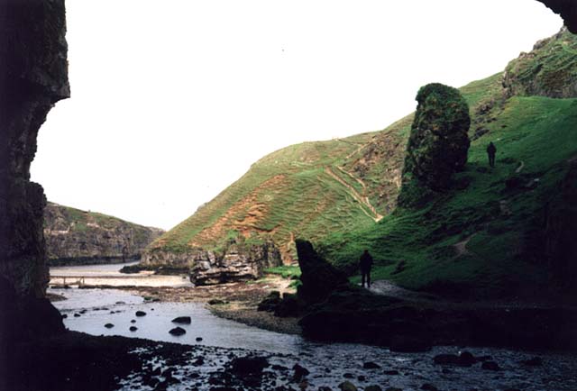
We visited Smoo Cave. A huge sea cave that appears like a vast cathedral of rock with a breath taking waterfall booming in a side cavern. Traces of human habitation have been found here stretching back to neolithic times.
Noting on the map that ancient places were nearby, we headed into the hills. First of all finding a cairn. Nothing spectacular, but the views were magnificent. Occasionally, a window would open in the low cloud and offer us spectacular views onto the loch below, or over to the Kyle of Durness. It felt like we were in the seat of the gods.
We headed off across the blasted plateau in search of a Pictish Wheelhouse marked on the OS map. After much crossing of streams (during which Shaun performed the most spectacular of salmon leaps across a burn to land in a crumple heap half in, half out of the water) and upping and downing, we spied an outcrop. Scott reached the top first and let a loud whoop! Upon reaching the top we found ourselves looking down onto the most perfectly preserved wheelhouse I’ve ever seen. I don’t know if it has been restored at any time, I suspect not. The whole thing seems too jumbled to be reconstructed.
The afternoon was wearing on, and as this was the day that Manchester United were to play Bayern Munich in the Champion’s League Final, Scott was keen to not only get to the pub to watch it, but to also secure the best seat in the house! We marched back down the hill, following the burn which tumbled down the hillside in a series of mini-waterfalls, back to the croft, no time for a shower but off to the pub stinking of the hills!
This was to be one of the more bizarre evenings of my life! The Sango Sands pub is a peculiar place. Perched on top of the cliffs overlooking the North Atlantic, with a pool table that looks like they made it themselves out of hardboard and egg boxes! All the balls are different sizes and it is underpinned with telephone directories.
Scott perched himself in front of the pub TV, Ed and I played (wonky) pool and Shaun went to watch for whales from the cliff top. Slowly the pub began to fill... with Germans. I realised that all the British people hated Man U and were supporting Bayern, and all the Germans hated Bayern and were supporting Man U! Very bizarre when anyone scored a goal.
We got talking to a guy called Colin, who ran boat trips at Smoo Cave. He sorted the beers and we trooped off to his after closing time. We found ourselves in what could be a council estate street in any part of the country, but at the foot of a big craggy hill on one side and sandy coves on the other.
The next day we took an excursion to Balnakeil Beach, Church and Craft Village. An old army installation that has become an artist’s colony. There is also reputedly to be a stone circle near here, but we didn’t find it.
On the way back, driving along the Kyle of Durness, we spotted a guy at the roadside watching the sky with a pair of binoculars. Scott pulled over and we looked up to see a Golden Eagle cruising the thermals right above us. A fantastic sight. Back in the car, I took a glance at the map and noticed we were right next to a site marked as stone circles on the map. We found the site over a hillock in the field next to the road.
Know locally as The Ord, the site’s entrance appears to be through the remains of three ditches which enclose an area containing groups of stones and a low rubble wall at the rear. The stones appear to be too closely set together to be true stone circles and areas of spoil again seem very small to be the remains of collapsed cairns. I guess their likeliest purpose is hut circles in a settlement site. There is also a low circular, stone enclosure a few yards away, which looks more like a modern sheep pen than anything ancient.
Pics of the Wheelhouse and The Ord can be viewed at megalithic.co.uk/user.php?op=userinfo&uname=andy_h
Another site nearby that is worth a visit is the ruins of Ardvreck Castle near Inchnadamph. Not a megalithic site, but very romantic and picturesque.
The Ord settlement site and Hut Circles overlooving the Kyle of Durness in Sutherland

The wonderfully preserved Pictish Wheelhouse in the hills above Laid, nr Durness, Sutherland

The wonderfully preserved Pictish Wheelhouse in the hills above Laid, nr Durness, Sutherland

The wonderfully preserved Pictish Wheelhouse in the hills above Laid, nr Durness, Sutherland

A description of all aspects and history of Smoo Cave
Village website including a brief history of area
Noting on the map that ancient places were nearby, we headed into the hills. First of all finding a cairn. Nothing spectacular, but the views were magnificent. Occasionally, a window would open in the low cloud and offer us spectacular views onto the loch below, or over to the Kyle of Durness. It felt like we were in the seat of the gods.
We headed off across the blasted plateau in search of a Pictish Wheelhouse marked on the OS map. After much crossing of streams (during which Shaun performed the most spectacular of salmon leaps across a burn to land in a crumple heap half in, half out of the water) and upping and downing, we spied an outcrop. Scott reached the top first and let a loud whoop! Upon reaching the top we found ourselves looking down onto the most perfectly preserved wheelhouse I’ve ever seen. I don’t know if it has been restored at any time, I suspect not. The whole thing seems too jumbled to be reconstructed.
The next day we took an excursion to Balnakeil Beach, Church and Craft Village. An old army installation that has become an artist’s colony. There is also reputedly to be a stone circle near here, but we didn’t find it.
On the way back, driving along the Kyle of Durness, we spotted a guy at the roadside watching the sky with a pair of binoculars. Scott pulled over and we looked up to see a Golden Eagle cruising the thermals right above us. A fantastic sight. Back in the car, I took a glance at the map and noticed we were right next to a site marked as stone circles on the map. We found the site over a hillock in the field next to the road.
Know locally as The Ord, the site’s entrance appears to be through the remains of three ditches which enclose an area containing groups of stones and a low rubble wall at the rear. The stones appear to be too closely set together to be true stone circles and areas of spoil again seem very small to be the remains of collapsed cairns. I guess their likeliest purpose is hut circles in a settlement site. There is also a low circular, stone enclosure a few yards away, which looks more like a modern sheep pen than anything ancient.

The Ord settlement site and Hut Circles overlooving the Kyle of Durness in Sutherland

The Ord settlement site and Hut Circles overlooving the Kyle of Durness in Sutherland