Previous 20 Previous 20 | Showing 21-37 of 37 fieldnotes. Most recent first
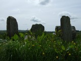
Here lie the bones of a monster. The entry in the Archaeological Inventory, following O'Nualláin, describes a stone pair - two slabs of mismatched height, the taller over two metres - but doesn't mention the brooding block swaddled in whitethorn, 20 metres to the east.(1,2) Or the others fallen south from the body of the fence. While these latter may be coincidental the eastern megalith, tall, thick and imposing, sits the line of the recorded pair in position and wide-face orientation.
Only Aubrey Burl, with a politely suggestive question mark after the '2 st st' in his gazetteer, gives a published hint of the giant that must have stretched here.(3)
'Sleep.
Do not fear the roaming.
eye.
Sleep.'
Federico Garcia Lorca, from 'Berceuse for a Sleeping Mirror'.
Permission to visit may be obtained from the farmhouse immediately south, on the left hand side of the road.
(1) Archaeological Inventory of Cork, Volume 1, West Cork, 1992, no.196; 42
(2) O'Nualláin, PRIA 88 C, 1988, no.133; 247
(3) Burl, 'From Carnac to Callanish: The Prehistoric Stone Rows and Avenues of Britain, Ireland and Brittany', 1993; 261.
|
There's something just satisfying about the yellow of freshly cut fields - as redolent of the May/June cusp as hedges full of hawthorn blossom or the crisp heat, not yet turned heavy and dead on the senses.
A great time of the year for Bohonagh. The nettles and long grass around it only seem to enhance its wildness and great age, its dominance of what would be an overwhelming growth for a smaller site.
It's an interesting test. Swap places in your mind with Drombeg. Would it be improved here, in these surroundings? Perhaps. Perhaps not. Bohonagh would certainly lose something by being tidied up.
The 30 odd heifers crying aggressively outside the fence give a reminder of the origin of the townland's name.
|
The GPS reading above is for the obvious standing stone, though the first sight over the gate is the horned boulder. Sketched by Webster almost eighty years ago and described as a "demi-dolmen", he proposed that it and the recumbent pillar immediately to the east were the remains of some type of monument.(1) Jack Roberts wrote that it could be "loosely classed as a cromlech".(2).
My suspicion is that it may have been an upright block that has sagged and split. The main cut smoothly separates the centre, forming a sort of dry megalithic sandwich, while the upper portion is bisected into two further pieces, both resting on the lower.
The horn effect is quite striking. Bronze trumpets sounding a bull call while flames and figures dance. Maybe not, but who knows?
The "anomalous stone group" described by the Inventory is about 50m north and comprises a standing stone and a prostrate slab.(3) The compilers seem to have missed the stone described by Roberts, that now forms part of the hedge and which prompts the tantalising possibility of a three, or even four, stone arrangement. Webster's sketch shows the field before the wall was erected; then containing the two standing stones, the grounded slab and a fine stretch of empty grass as far as the house at Quaker's crossroads. From a position in the centre of the triangle, and looking southish - parallel to a line between the two uprights, your gaze travels straight across to the large boulder. Contact.
(1) Webster, 'Rude Stone Monuments in West Cork', JCHAS 35, 1930; 35.
(2) Roberts, 'Exploring West Cork', 1988, Ch(1) 39; 44
(3) Archaeological Inventory of County Cork, Voume 1, West Cork, 1992, 926; 113.
|
Something worth pointing out about Lettergorman, with regard to the quartz boulder. It has previously been noted, a belief held by the former owner, that the stone was probably moved in from the field, from a position either along the axis or in line with Carrigfadda.
However the stone has been in the same position since Windele's survey in the mid 1800's and when viewed from centre-circle crudely indicates the four stone grouping on the slope of Maulatanvally. An arrangement three-quarters composed of quartz.
|
So, this is it for Garryglass - deserted, destroyed and now grown over. Like a frontier fort reduced to a limp point of rubble it left the last century with just one stone, presumably the central monolith - having entered it with eleven others. Meanwhile the 'rough pasture' mentioned in O'Nuallain's 1984 survey has become a dense plantation of trees and the clearing left around the stone has filled with a head-high and almost impenetrable thickness of furze and bramble. When finally I fought my way through I was almost tempted to kiss it so it could wake up and make me its prince.
Don't visit unless:
(1) You really like quartz
(2) You have a GPS and follow these coordinates. Even then there's a probable reading difference and...
(3) You don't mind a bit of discomfort and the probability of ripped clothing.
Something about nothing maybe... On the top of the knoll in the field to the west there's a prostrate 'orthostat-sized' slab with one level end. A doorway for the little men or one of the missing stones...?
|
Pointing a touch further north than Bohonagh, in terms of declination, with a measurement of 1.22 degrees*, Knocks North provides a cruder alignment to the equinoxes, further hindered by the tree growth on the horizon. On the other hand the local historian that has witnessed it mentioned the sparkling of the falling sun on the big splash of quartz on the axial stone. Worth a visit, I think.
Permission can be obtained from the farm to the south, on the left hand side of the road.
* Patrick and Freeman, 'Revised Surveys of Cork-Kerry Stone Circles', Archaeoastronomy, no.5 (JHA, xiv (1983)); S51: Knocks/A.
|
Just a quick few words to inform anyone who may have visited this site previously that the land owner has removed the hedge that was about fifteen metres west of the complex. It's a bit of a cold rinse to the senses if you're used to seeing it the way it was, but it does open the view out. Less distraction in the eyeline I suppose.
The ground is intact, dry and solid for a distance of about ten metres from the monument but between this and the gates to the west and east it looks to have been turned over and reseeded, with grass growing in isolated clumps. This ground, even in the dry conditions at the moment, was excessively waterlogged. No change there then.
|
A very steep climb. 650 metres according to Carleton Jones' gazzeteer (Temples of Stone: Exploring the Megalithic Tombs of Ireland, 2007), and straight up. The tomb is just the other side of the peak, at the end of the track.
Inside the chamber it's diffcult not to engage with the salmon-pink flush of the stones, freckled with bits of quartz and this and that, pitted and alternatively smooth as you gaze along their features. Then the passageway pulls your attention out across the vast plain underneath. It points much too far north, at least on my compass, for a solar orientation but it's tempting to imagine, having read Bawn's bit of folklore below, some ancient crumble of bone staring out over his former domain.
A gorgeous place.
|
One of Somerville's five stone circles of West Cork (JCHAS 35, 1930; 79), Maulatanvally can suffer when placed in comparison with its more intact brethren. Lacking the more monumental construction and solar event alignments of Drombeg and Bohonagh, the beauty and seclusion of Reenascreena and the mystery of the lost world at Carrigagrenane SW, it could almost be the odd child of large local sites.
Situated on a platform, with the ground falling swiftly to the south and west, the circle is pushed fairly tightly against the eastern field boundary. The gap and deeply rutted track from the next field are right beside it and just on the rise to the north is a chicken factory. After the drop to the west the ground rises steeply again, over the Dunmanway-Rosscarbery road, to reach a hill summit that gives the townland its name. Beyond this lies the omnipresent Carrigfadda.
The rise of ground to the west pulls an axial azimuth of 256.5 back to a declination of -5.4 (Ruggles, Astronomy in Prehistoric Britain and Ireland, 1999; 217), offering no obvious solar or lunar event to a modern observer. What might be significant however is its direct line to the peak on the northern section of Carrigfadda, the imposing centre of the source forks of the Argideen river, a flow whose silver is mirrored in the quartz components of many of these monuments.
According to O'Nuallain (PRIA 84C, 1984; 21) there would have been originally 11 stones in the perimeter of a circle with a common local diameter of about 9.5 metres. Seven stones remain, with four in an arc at the western side and three in a group to the east. The entire northern side is missing, including what should have been the northern portal. Placed slightly off centre is the squarish, box-like quartz block, smaller than that at Lettergorman SW and Carrigagrenane NE but still dazzlingly white.
The western section contains the axial stone, long but low at just over knee height, its two flankers and the continuing stone to the north. The top of the axial is rather weathered and it has a curious seam running across the middle of its inner face. The eastern side still has the radially set southern portal, now leaning somewhat to the north, with a rather sharp looking stump and a round topped circle stone to the south. Despite the wrecked guttery look to the remains this circle hasn't deteriorated since at least as far back as 1930 and possibly much further (see plan below).
A slightly unusual aspect to the ring is the position of the axial stone with regard to the remaining stones. It would seem to be positioned to be perpindicular to a line running between the stump to the south of the portal and that stone, rather than facing a line to the north of it, between it and the presumed northern portal. This stump can't be a portal here because it is set with its long axis along the perimeter and it is well off the centre line of the circle as deduced from the remaining stones.
The whole eastern section seems to be flattened and pushed slightly too far north to make a true circle. If a secondary alignment was intended it would be closer to an equinox event than the mid-portals-axial line, but this has never been surveyed.
This site is located in the second field to the east of the road from Dunmanway to Rosscarbery, just down from the rim of the hill after Kippagh bridge. There is a little lay-by as the second indentation in the ditch after the chicken factory. Look over the brambles here.
|
Just before the summer I went to a talk given by Professor O'Brien on the prehistory of the Dunmanway area. While the first half of his presentation was a steady trot around the expected topic, he spent the rest of the time speaking about his excavation at Clashanimud, a townland that he ventured to translate as 'the trench of the timber'. It's possible that some folk memory remained into historic times of this massive wooden construction.
I've included the newpaper report from August in the miscellaneous section below, as a reasonable summary of his findings. On visiting the site myself in early June I found access to be easy, with a parking spot just up the hill from the entrance at the eastern side.
|
The remains of this probable five stone circle (O'Nuallain PRIA 84C, 1984; 44) are situated at the eastern end of a marshy field which slopes down gently north to a noisy and intensely overgrown stream. The ground rises towards Carrigfadda to the southwest but a view to the horizon in this direction is obscured by a line of trees near the southern field boundary.
Two hip-height stones; the axial and its northern flanker are all that is left to immediate sight. O'Nuallain noticed a quartz boulder 1.7m and a stone 90cm at their maximum placed against the fence a few yards to the east. I could only find the quartz stone, and then only by its brilliance speckling through the earth and growth now covering it. I dusted it off somewhat for the photograph and then covered it up again.
The axial stone leans outwards considerably to the west but looks as if it originally presented a level, flat top, pitted in the centre. The flanker leans inwards to the south giving it a rather bulbous look, tapering to the bottom. Its shading and shape are very striking to the eye.
O'Nuallain grants the possibility that the two stones at the fence originally formed part of the monument and it certainly would not be unusual for the coincidence of a sizeable quartz block with a stone circle in this area. Its dimensions are apparently in excess of the wonderful conglomerate in Lettergorman and I would have loved to have seen more than the foot-size patch I scratched open.
The site can be approached with courage or recklessness through the marsh, brambles, water traps, sheer drops and wire fences from the road to the east but may be better attempted from the Carrigfadda side.
|
Three fields in from the really rather good farm park. Great selection of ride-ons for kids.
According to Frances Lynch (Prehistoric Anglesey 1970, 167):
"More is known about the burials close to the large stones at Henblas, Llangristiolus, but a good deal of confusion remains. The stones in question, which are huge glacial erratics, were long considered to be an artificial structure, some monstrous megalithic tomb, and have naturally attracted a good deal of legend and speculation. It seems clear that there were originally other stones," (see Rhiannon below) "probably more erratics, in the vicinity, and that in removing these an urn containing burnt bones and a ring of blue glass were found. Even though the stones are a natural feature, this burial need not be doubted for they are a very remarkable phenomenon which must have attracted the attention and admiration of a people used to setting up meini hirion and other large stone monuments"
|
In the picture I posted above I show the stones as viewed from a distance of about 45 feet.
According to Burl (Guide to the Stone Circles of Britain, Ireland and Brittany 1995, 2005), quoting the Reverend Henry Rowlands, this site contained a circle of 'eight or nine great pillar-stones... about twelve or fourteen yards diameter'.
Is it possible to imagine a stone just in front of my position and an arc of maybe three or four megaliths continuing on either side to meet at the pair opposite?
|
I've not got a lot to add here, given the fame of this site and its comprehensive coverage in all sorts of guide books. A great little volume written by the O'Kellys is available from the proud and committed landowner.
Aubrey Burl in his big 'Stone Circles of...' book remarks that the monument's relationships lie with the Wicklow circles and not with the Scottish recumbent and Munster axial stone varieties. I'm not so sure that a connection to the ASCs should be written off completely. Two northeastern portals look along a main axis, with a winter sunset declination, to two stones at the southwest which, because they sit together, give the same shape as one more broad than high. A supplied v-notch sits in the middle of these 'axial stones', an effect also offered by natural valleys in the sightlines of the Winter Solstice circles of Drombeg and Lettergorman South. Maybe in 1000 years an idea could mutate and fuse with other influences and appear some distance to the South?
|
I've been debating with myself for a long time about whether or not to include this site. These aren't even really field notes, since they're being written in my living-room, months after my last visit there. If an Englishman's home is his castle, does that make an Irishman's sitting-room his field?
Burl, sounding almost bitter in his guide entry, gives it a special category, namely 'unseeable', and discourages any visit not involved with official clearance. Ruggles in his orientation tables at the rear of 'Astronomy in Prehistoric Britain and Ireland' (1999; 217), mentions the immovable vegetation that made accurate survey impossible. The monument is almost drowned in a wash of turbulent growth. Yet it has not always been this way.
I have posted Somerville's plan from the beginning of the 20th century. A print of Webster's sketch of 1930 hangs on my wall, the circle open and clear. As long as I have been interested in the past, this site has fascinated, or rather, obsessed me.
It sits on a slight rise at the north side of a tidy little field. Carrigfadda looms to the west. The ground is open to the south and on a sunny day you can almost feed on the glow and brightness in the air. Rabbits make surprised darts across in front of you and the only sounds are earfuls and earfuls of natural life.
A quick glance at O'Nuallain's 1984 plan will give you an idea of the shape of the monument: partially used as a fence on the western side, it is 8.5 metres in diameter, reckoned to have contained 19 stones up to 1.1 metres high, with a 70cm high and 1.4 metre wide axial stone.
The plans diverge over two facts. O'Nuallain shows the detached radial portals, strangely missed by Somerville. On the other hand the one foot high centre stone shown and described by Somerville and Webster was either missing or concealed when O'Nuallain's survey took place.
I have poked through here myself at winter time when things die back a bit and experienced a kind of euphoria as portals and circle stones are revealed. It must be tied with its being hidden, yet being there, its sparkling location, the character and perfect size of its pillars, my immersion in its history and forbidden reputation and perhaps a multitude of other things. It's difficult to exactly put a finger on why it should but I know that this place affects me more than any other.
Access is over a gate with some dire warnings about unauthorised entry, but the farm is just down the road to the south if you want to give it a go and ask.
|
This fine alignment, looking like nothing so much as the plates of a submerging dinosaur, nestles on a plateau just south of the forestry on the other side of the hill from the four-poster at Lettergorman N. Lettergorman S is downhill slightly to the southwest, in the first field beyond the townland boundary.
The tallest stone, a fin-shaped pillar almost 3 metres tall, is at the northeast of the row. The middle stone is a straightforward block, and the southwesterly stone, possibly others, are obscured in a wig of dead vegetation.
The row is aligned, looking in this direction (and fairly unremarkably), on the eastern slope of the hillock of Maulatanavally. Clive Ruggles (Astronomy in Prehistoric Britain and Ireland, 1999; 220) mentions a direct alignment in the opposite direction, to a hilltop to the northeast, but the forestry wall has cut off any sight of this. The views would seem to have been extensive in all directions before the plantation.
A word of warning. Due to unbelievably sodden ground in the approach from the west in wintertime it may be wiser to come at it via the farm to the east.
|
Aubrey Burl, in his guide, reckons this to be an 'outstanding site' with 'easy' access. To be honest I made a bit of a mess of it myself, but it isn't really that hard to find.
Take the road south past the circles at Kealkil and Breeny More. When you eventually reach the T-junction head east for a mile and a quarter. There should be two houses down the slope to your right, with very close parallel driveways. There will also be a bungalow on the hill to your left. You can ask for permission here.
The gateway to the four-poster is a short distance back the road to the west. Keep to the track and you should pass back above the owner's bungalow. You will cross a small stream and see an old wall topped with holly trees.
Walk up the hill past this and you can now, hopefully, see the tip of the tallest stone.
Gortnacowly is one of just five accepted four-posters in Cork and Kerry. This category of monument was only confirmed to exist here in the last thirty years. Its fourth stone, like that at Lettergorman, is missing. (According to O'Nuaillain's 1984 description it was still present in 1899.)
The three surviving stones are all tall, again like Lettergorman, miles and hills away to the south east. On the other hand the domination of the triangle by one huge ten foot hulk gives it an immediate visual similarity to four stoned Cappaboy Beg, a hill and valley to the north. The monolith there is at the north east of the structure, while here it stands to the south west. Apparently at Reenkilla in Kerry, which I have yet to see, there is a similar domination to the north west.
Its setting is spectacular. The Maughanaclea hills rise above it to the north east. To the east sits Nowen hill and to the south stretches wide Mullaghmesha.
The monument itself however leaves me feeling somewhat underwhelmed. Perhaps it's the absence of the fourth stone. Even when a circle mirrors the horizon, or perhaps because a circle does so, it has an intentional impact on the landscape. With the fourth stone removed the structure seems more random and natural. Or maybe I just like things round.
PS. I'll stick in a plan 'after' O'Nuallain or Burl to show where the missing stone could have been.
|
Previous 20 | Showing 21-37 of 37 fieldnotes. Most recent first |
"Can this be death?" thought Prince Andrew, looking with a quite new, envious glance at the grass, the wormwood and the streamlet of smoke that curled up from the rotating black ball. "I cannot, I do not wish to die. I love life - I love this grass, this earth, this air..." He thought this, and at the same time remembered that people were looking at him.
Leo Tolstoy, 'War and Peace', Book Three, Part II, 36.
|