Showing 1-50 of 80 posts. Most recent first | Next 50 
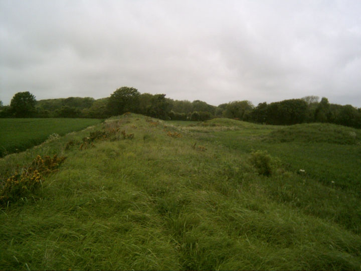
Big gorse clearance on top of Wolstonbury
They have cleared all of the (quite substantial) gorse within the enclosure, revealing a lot more lumps and bumps. Worth a look if you are in the area.
|

CHALK
Experience the landscape
Installation, performance, and experiential walks on the South Downs in partnership with the National Trust
April – October 2011
Performance journeys
Wolstonbury Hill (Brighton) October 8/9
Join RED EARTH to explore the archaeology and ecology of the South Downs: visit two site-specific installations, and come and be part of the performance journeys across these two stunning landscapes.
More info: http://www.redearth.co.uk/
|
Werner Herzog on Cave of Forgotten Dreams: 'The awakening of the modern human soul' - video.
Werner Herzog investigates the 'proto-cinema' of the 32,000-year-old paintings inside France's Chauvet cave – the subject of his film Cave of Forgotten Dreams – and discusses his project with Cambridge University archaeologists.
|
Original thinking
The Guardian 27/10/09
'The booming interest in archaeology suggests a new quest for identity in a time of rapid change'
Question Time descended into pure farce when Nick Griffin was challenged by Bonnie Greer to define what he meant by the "indigenous" peoples of Britain. It must have been the first time that the Ice Age had been dragged into the heat of contemporary political debate.
What emerged from their conversation was riddled with absurd notions, and no doubt had Britain's considerable army of amateur archaeologists tearing their hair out. For we are currently in the midst of an unprecedented archaeology boom, the public appetite for the subject – TV programmes, museum and site visits and 180,000 metal detector enthusiasts – never having been higher.
There was a comparable surge in interest in the subject during the middle decades of the 19th century; it was the period that antiquarianism – the collecting of quaint objects – began to develop into the academic discipline of archaeology and the pioneers were the barrow-diggers. Often clerics, these men dug their way through hundreds of barrows. In North Yorkshire, Canon William Greenwell dug 400 mounds in 50 years and ended up selling his collection to the British Museum. Alongside them sprung up the county historical societies which began the work of analysing and recording this new area of study.
Full Article
|
Archaeologists find skulls on route of new road
The skulls of scores of young men have been found in a burial pit on the route of a new road in Dorset.
So far 45 skulls, believed to be almost 2,000 years old, have been found, and more may be found as the pit is emptied. Archaeologists have called the discovery extraordinary, saying it could be evidence of a disaster, a mass execution, a battle or possibly an epidemic.
The bones recovered so far are still being examined but most appear to be of young men, and are believed to date back to the late iron age or early Roman period. They may be evidence of a fatal encounter between the invaders and the local population, buried at a site which had ritual significance for thousands of years before they died.
David Score, project manager for Oxford Archaeology, said: "There are lots of different types of burial where skeletons may be aligned along a compass axis or in a crouched position, but to find something like this is just incredible.
"We're still working on carefully recording and recovering all of the skeletons, which will be taken back to our offices in Oxford for detailed analysis, and trying to piece together the extraordinary story behind these remains."
As well as the skulls, the archaeologists found torso and leg bones buried in separate sections of the pit.
"It's very early days, but so far, after a visit to the site by our head of burial services, the skulls appear to be predominantly those of young men," Score said.
"At the moment we don't fully understand how or why the remains have come to be deposited in the pit but it seems highly likely that some kind of catastrophic event such as war, disease or execution has occurred."
The Oxford team completed the main excavation at Ridgeway Hill last year, uncovering a series of earlier burials, including cremated remains, skeletons and a man buried with a dagger under a round barrow. This year they had been monitoring the site as roadworks began, but the discovery a fortnight ago, was a complete surprise.
Construction work has stopped, the site has been fenced off and is under 24-hour security, and Dorset county council has appealed to the public to stay away and let the archaeologists get on with their work.
The pit is on the outskirts of Weymouth, where a new relief road is being built, but stands by one of the oldest roads in Europe, the Ridgeway. The site was used for ritual burials for thousands of years before the young men died: the archaeologists had already found burials from neolithic to Roman times, as well as pottery, animal bones and flint tools.
http://www.guardian.co.uk/science/2009/jun/11/skulls-dorset-road-burial-pit
|
This site consists of a saucer barrow and three bowl barrows.
Be warned, you will enter the field and get all excited when you think the old dew pond is the saucer barrow - it isn't.
The edge of the saucer barrow almost touches the dewpond bank and is located just to the south of it.
This is the first time I've seen a saucer barrow and it is basically a henge like circular bank with some humps and bumps in the center. It has obviously been very truncated by the plough. It has a much larger circumference than your average Sussex Bronze Age barrow.
The 3 bowl barrows are so faint as to almost be invisible, but are just about discernible.
A lone sarsen sits by the style at the southern entrance to the field.
|

|

|
 
|
Scientists seek fresh chance to dig up Stonehenge's secrets
The Observer - 25 July 2005
Stonehenge has always mystified. Julius Caesar thought it was the work of druids, medieval scholars believed it was the handiwork of Merlin, while local folk tales simply blamed the devil.
Now scientists are demanding a full-scale research programme be launched to update our knowledge of the monument and discover precisely who built it and its burial barrow graves.
Click here for full article: http://observer.guardian.co.uk/uk_news/story/0,6903,1535032,00.html
|
New work overturns date for chalk Long Man of Wilmington.
Rather old news now, but this covers the discoveries linked to the excavation in 2003.
|

|
 
|
If you park in the car park to the NE of the ring, it is a long climb up a 'bostal' path, and then you double back on yourself as you turn left at the top onto the South Downs Way. This is a bit of a drag, but better than trying to scramble more directly up the steep, wooded slopes. We tried coming down the 'quick way' but soon realised the only way down was on your backside!
Alternatively you could park to the SW and take the South Downs Way east to the ring.
I must admit to having a slightly strange sense of foreboding as we made the climb and I am not sure why. Maybe it was the vehicles we had seen parked up on the hill, or the spooky local folklore I had read (see links).
When you get up here, you are rewarded with a fantastic view. Cissbury Ring and flint mines to the South with the blue sea as a backdrop and Wolstonbury jutting out sphinx-like to the East. An excellent vantage point.
We were disappointed to discover 3 4WD's and parked next to the Ring, with their drivers were packing up after a nights camping. When I spotted them from the bottom of the hill I was expecting a wild Solstice free festival, but it was just some SUV driving muppets who didn't even give us the time of day. Quite what these individuals were doing up here on the midsummer's eve I don't know (black magic to bring petrol prices down perhaps?), but how lazy and disrespectful to bring your stinking vehicles across an area of outstanding natural beauty and park them next to an ancient monument. Needless to say we were happy to see them trundle off and then we had the place to ourselves.
Most of the beech trees planted by Charles Goring in 1706 were indeed flattened in the storms of 1987. The ones that remain are on the south bank mostly, and provide some delicious shade. The interior of the Ring has been replanted, but is still quite scrubby and immature.
We were surprised to find a barbed wire fence around the interior, but there is a well worn entrance at the east (close to the original entrance).
I am always interested in places that the R*man's decided to build temples on. Maiden Castle is one of the most famous examples, and it always suggests an existing sacred function for the site.
I ventured into the interior and it is a bit of a creepy wood with evidence of lots of campfires.
It is so overgrown I couldn't see any evidence of the temple, which is apparently only a few inches below the surface. I did manage to get a bit lost in there and had a brief 'Blair Witch' moment when I was convinced I wasn't going to find my way out! I now put this down to the 8% Cider and an overactive imagination.
There are also a couple of interesting cross ridge dykes, bowl, saucer, platform barrows and hlaews (rare Saxon Burial mounds) Click the Magic plug in on this page for more info on their locations.
Check out the links on this page for more background and go and feel the vibes of this absorbing place for yourself.This post appears as part of the blog post " A Sussex Solstice" |
It should also be noted that William Hamper, in 1806, noted a barrow within the NW quadrant of the Wolstonbury hilltop enclosures. No clear trace of this exists, and it is possible that Hamper mistook quarry spoil for a barrow. However, if it was a barrow it is possible that some of the Roman coins recorded by Hamper and the other prestige items and weaponry alleged to be found within the enclosure may have originated from it as primary or secondary deposits.This post appears as part of the blog post " A Sussex Solstice" |
This interesting specimen is also situated on farm land, just to the NW of the bowl barrow. It is a long stretched out thing that runs down the slope to the west. Again it seems badly truncated, but it is the only platform barrow I have knowingly visited, so it is worth a look.This post appears as part of the blog post " A Sussex Solstice" |
 
|
Like so many, the apparent bowl barrow on Wolstonbury has been raided and flattened by the plough. It lies on farm land just to the east of the main track that leads to the hill from the south, at the kink in the 'cross ridge dyke'.
While it seems to be sited across the northern bank of the linear ditch and so appears later than the dyke itself, this may be a false impression. The barrow has been so badly disrupted (presumably by an unrecorded antiquarian investigation) that it is possible that excavated soil has been thrown over the linear earthwork.
It is also possible that the round mound could represent the mutilated remains of a later fire beacon mound. (But let's keep that quiet until someone proves it, eh?)This post appears as part of the blog post " A Sussex Solstice" |
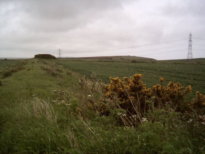
This linear earthwork appears to be one of the later prehistoric linear boundaries recorded from the southern chalklands. What exactly their purpose was has regularly defied interpretation. They have variously been referred to as; roads, defensive outworks, covered ways, barriers, toll bars or drove ways, 'Celtic' fields, ranch boundaries or pastoral enclosures. Even precise terminology is difficult. (I am using 'Dyke' on TMA for want of a better site type, but please do not take this as an implication of function.)This post appears as part of the blog post " A Sussex Solstice" |
This 'dyke' cuts across the southern spur neck of Wolstonbury Hill, and this morning I find myself wondering where the main point of access was (if one originally existed) on this linear earthwork. Could it be at the central kink in the dyke, where a round barrow now sits on the Northern bank, or the area where the modern track bisects the bank? I walk down the ditch to where the dyke peters out and the slope gets steeper. The date of construction remains unknown. It could relate to a late Bronze Age/ Early Iron Age period of cultivation. Or, it could represent a 'defensive outwork' to the (speculative) period of defensive remodelling of Enclosure 'C' on top of the hill. As yet, nobody knows. I turn back and follow the ditch up to the 'barrow'.This post appears as part of the blog post " A Sussex Solstice" |
Now this is a barrow! I've just got to walk the length of this thing, and
I am rewarded when I reach the other end and a deer springs out from behind one the two round barrows that sit next to each other just to the North of this incredible monument.
She runs through the crops to the hedge while I stand, exalted, snapping away like a madman, trying to capture a moment I should just be in, but I suppose that is the modern condition!
These 2 north flanking barrows aren't shown on the OS map, but the round barrows at both ends are. The road runs between the east end of the bank and the round barrow at that end. This is Chalky Road, which interestingly runs straight up to Broadmayne and the stones/ earthworks there.
Looking around:
Barrows, Barrows everywhere!
An important spot,
I think.
|
  
|
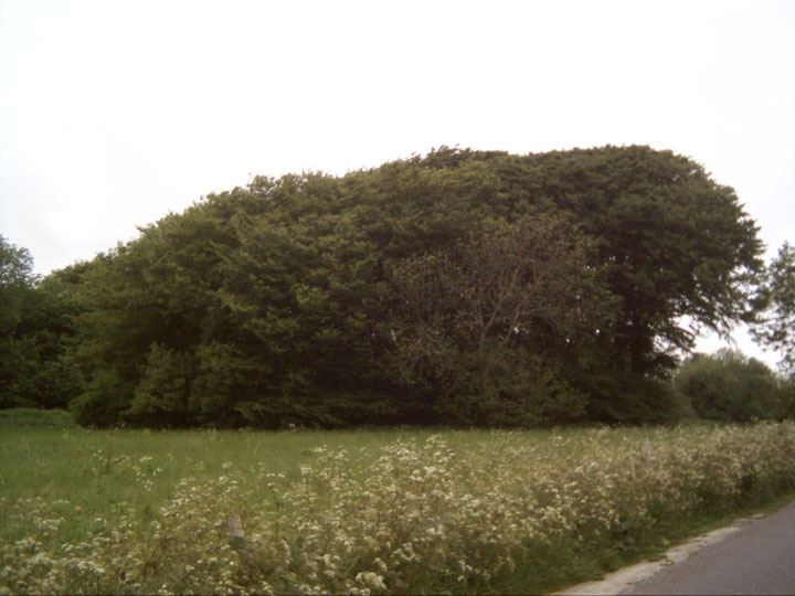
This tree covered round barrow lies between the road and the east side of Came Wood itself. (It actually lies to the West of the road, and I hadn't read Rhiannons folklore post so didn't listen for fairy music - it was too early in the day anyway!)
This is an atmospheric place and I feel compelled to sit awhile and soak it up. Although I have mixed feelings about the old fashion of planting barrows and earthworks with a crown of trees, they certainly add to the sacred feel of this site, encasing me in a green chamber on this June morning.
The crater in the top tells of a 'volcano' excavation;
In 1858 four internments were discovered, one of which had a necklace of amber beads, two of which had gold casings.
Look East and you face towards a line of 5 round barrows, with the bank barrow just beyond.
Many carvings on the trees here, the earliest I can spot is 1939. Needless to say, I don't add to them!
Think I'll go and have a peep through the trees at the wooded long barrow down the path to the North.
|
 
|
Came Wood is a feast of Neolithic and Bronze Age barrows of several varieties. The round barrows and long barrow south of the woods are generally on arable land and under cultivation, but in the wood itself there are 2 bell barrows, a pond barrow and a long barrow.
They lie at the end of the cemetery of barrows that stretch along the South Dorset Ridgeway. It has been suggested that they formed the boundary of territory based around the major Neolithic ritual monuments of Maiden Castle, Maumbury Rings, Mount Pleasant and the destroyed Flagstones and Greyhound Yard sites in Dorchester.
|

|
I approached this fort from the disused quarry on Coombe Valley Road to the west of the fort.
Possibly not the best way as it involves scrambling up sheer cliffs and over a fence.
It was obvious others had come this way though, and it did give me the feeling of being an invading Roman (which I quickly shook off, with a shudder!). If you carry on further up Coombe Valley Road there are footpaths for a gentler approach.
It's a cute, roughly triangular little enclosure of about 4 hectares and was protected by a single ditch and a rampart of limestone slabs, obtained from quarry ditches inside the fort.
There is an entrance on the South East side and many hut circles were discovered inside the ramparts that suggest the site was intensively occupied around 450BC. I am just going to have a peek over the western ramparts and then get back to my bike. This fort looks cool from a distance,
and the view down the valley must have reminded the occupants that this was a land worth defending.
There are some barrows within the ramparts also, but I know nothing about them.
|

|
Just off a minor road linking the village of Groombridge (and the B2110) with Royal Tunbridge Wells (and the A264 and A26)
Arrived at this site just after sunset on the way back to West Sussex after a look at the Addington/ Chestnuts Longbarrow and Coldrum.
We sneaked in through the open turnstile (You are supposed to pay £2 at the bar of the High Rocks Hotel to view the site, but as it was nearly dark we thought this wasn't good value!)
These certainly are some huge and impressive rock formations, overhangs and caves, and all the more atmospheric in the failing light. I thought I had seen some big old sarsens at Coldrum earlier in the day, but these great natural forms are giants compared to those.
Excavations in 1954 and 1956 revealed a range of microlith (small flint tool) types and flint knapping debris apparently associated with areas of charcoal and fire cracked flint. These are presumably the remains of fires or hearths, though whether they were contained in an independent structure, or whether the overhang itself provided enough protection is unclear. High Rocks has been carbon dated to around 4500BC, quite late in the Mesolithic. Nothing of the Mesolithic levels themselves can be seen, but you can get a good idea of the nature of the rock shelters that nestle at the base of the cliff.
The overhangs apparently provided shelter for a variety of Neolithic and Bronze Age hunting parties as well.
You can walk through the fissures in the rocks, and then ascend one of the rock cut stairways to traverse the top of the cliff over rickety looking wooden bridges. There is an Iron Age enclosure/ hill fort on top of the escarpment, but we didn't check that out this trip.
We thought we'd be clever and get back to the car park without going through the main gate, but soon discovered that they have done a pretty good job of fencing in the site, so if you go in the day you may well have to get your £2 out I am afraid!
|

|
|
The name 'Devils Dyke' was originally applied to the earthworks, but it is now used to cover the deep, natural valley shown on the bottom of the black and white aerial photo above.
|

|

|
Showing 1-50 of 80 posts. Most recent first | Next 50
Originally from Weymouth in Dorset, I now live in Hurst, West Sussex.
Would be pleased to meet up with folk in the area to visit and discuss local sites.
I have a particular interest in the mysterious collections of Sussex sarsens at various sites and the enigma of Wolstonbury Hill.
|
|


