Glos 'n' Oxon, Picnic People & Stomping in the Sun - Part 3
Part 1 is here
'Non-Avebury' AveburyMarlborough man
Sunday 27 July 2003
When planning this trip I'd been torn between trying to see as much as was humanly possible around Oxfordshire, or nipping down to the Avebury area.
If I went for the Avebury option I'd be going for sites other than the 'big 3' - Avebury itself, Silbury Hill and West Kennett Long Barrow. As I don't get dahn sarff often, they were the only ones I'd visited so far.
Inspired by talk at the picnic the day before I decided to forego the pleasures of Oxfordshire's more obscure sites, and instead go for a hell-for-leather approach to what became known to me as the 'non-Avebury' Avebury sites.
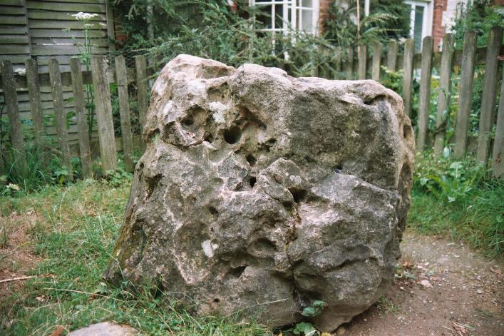
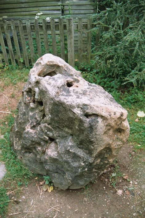
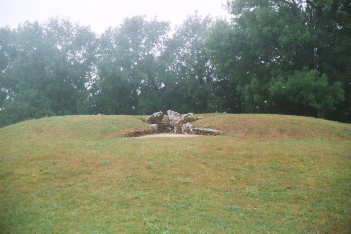
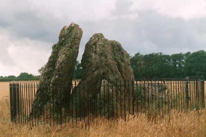
First stop though, on Baza's recommendation at the previous day's picnic, was Marlborough Mound.
Driving into Marlborough from the north on the A346 I followed the signs through the town towards Devizes. Along the town's main street, and at the end I spotted the (very narrow!) main entrance to Marlborough College.
There didn't look to be much room left to park in there, so I followed the main road round to the right, with the college on the left. the road went left again straight away, hugging the college walls. At this point, if not before, there was a sign for a visitors' car park and after a very short distance on the left, I turned into the college grounds.
 |
Sunday 27 July 2003
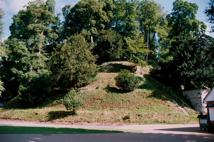
Having followed the signs into the visitors car park, I was now to the west of the college. Out of the car, I turned to look at the college and noticed that there were some unfeasibly high treetops towering over the buildings.
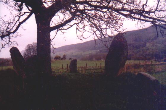
Knowing that there are trees on the Mound, I headed between the buildings and was soon standing beside the mound.
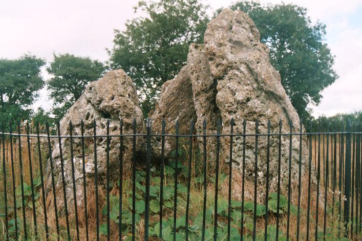
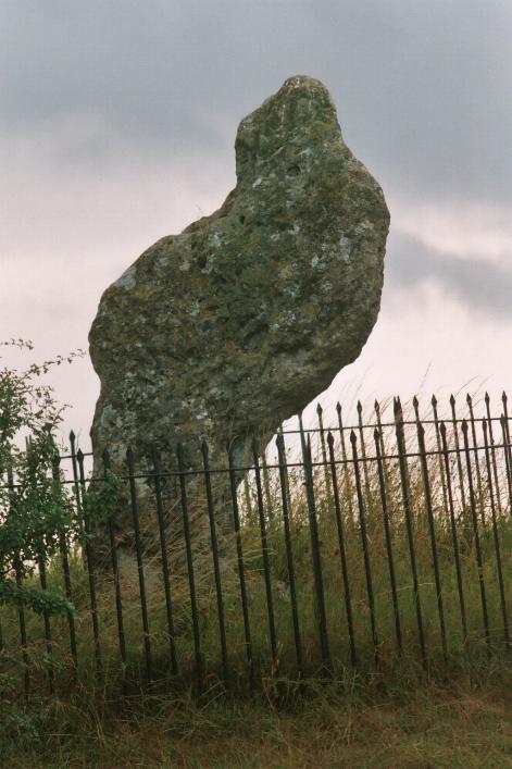
What a monster!!
And what a bizarre setting it has in the present day! It really is 'squished in' amongst the college buildings, almost giving the impression that should it decide to flex its muscles it would just sweep the encroaching buildings away.
The buildings make the mound difficult to photograph, but at the same time make for some interesting juxtapositions…. And I'm not even going to mention the irritating 'faux' standing stones etc 'littering' the college grounds….
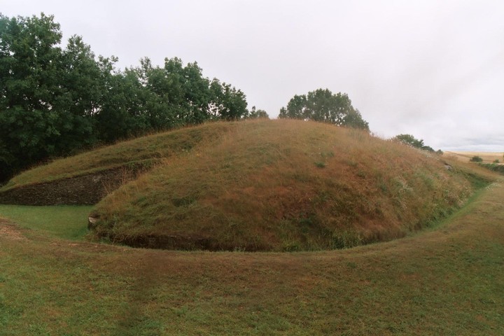
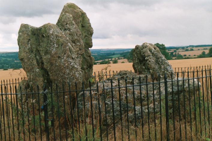
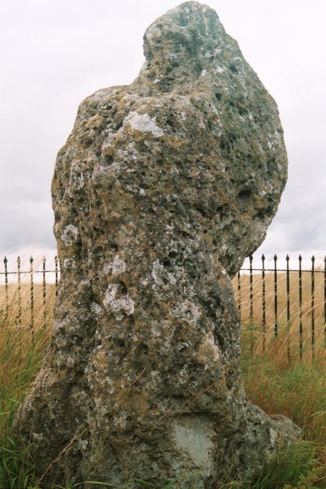
Reckoned to be a close relative of Silbury Hill the Mound is very impressive once you manage to really see it and to ignore the nearest college buildings and the trees growing from the mound itself. According to most sources it is definitely the second biggest manmade mound in Europe after Silbury.
Unfortunately, it's actual purpose seems to be even more mysterious than Silbury's, and surely it simply wouldn't be big enough to play a similar role to Silbury in any landscape of special significance that once existed here?
Even though it's huge and second only to Silbury, it's actually pretty tiny in comparison to Silbury itself, so any parallel may be limited at best.
Yet on the other hand I couldn't help speculating. If it truly is next biggest to Silbury, so close to Silbury, and of a similar age to Silbury, could they have had purposes in common?
Maybe it's fanciful, but get rid of the town, make the mound white with chalk as Silbury was, see it from the surrounding ancient paths. Could it have 'worked'?
Wonder if it was bare white chalk ….
I wrote the above before checking the big papery TMA. It turns out that on pages 78-9 Julian actually says something quite similar, but written (as is Julian's tendancy) as if it is proven fact. Perhaps it is. I was going to delete my musings but then I thought 'well, not everyone has the book….'
And he says it WAS chalk. As far as arranging visits is concerned, Baza's 'Sunday visit' tactic certainly worked for me at about 9.45am – absolutely nobody about to object to the fact that I hadn't got permission….
I spent about half an hour there, and the Mound is huge. It's fascinating. And it's hugely, fascinatingly perplexing!!!
But time was pressing, so it was 'on the road again' but only for about a mile and a half to the beginning of the path to the Devil's den.
Shake the devil
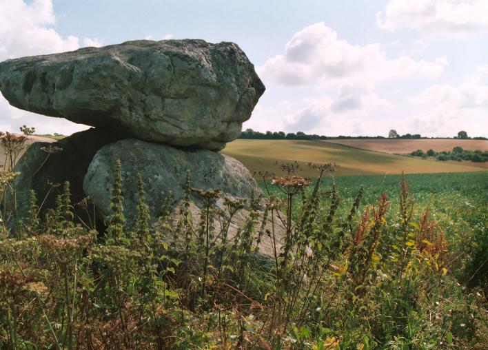
As Julian suggests in the big papery TMA, I parked on the left of the A4 at the entrance to Clatford Farm, on the verge in front of the farm sign on the west side of the entrance. I had to take care crossing the busy road to the beginning of the track at map ref SU158688.
If, as I did, you are going to walk a circular route past the Devil's Den over Fyfield Down, calling at Mother's Jam and the Polisher, and then returning by the Herepath and Long Tom, you might be better off parking in the car park at map ref SU159070. I'd also recommend a 1:25,000 map!
Sunday 27 July 2003
As Julian suggests in the big papery TMA, I parked on the left of the A4 at the entrance to Clatford Farm, on the verge in front of the farm sign on the west side of the entrance. I had to take care crossing the busy road to the beginning of the track at map ref SU158688.
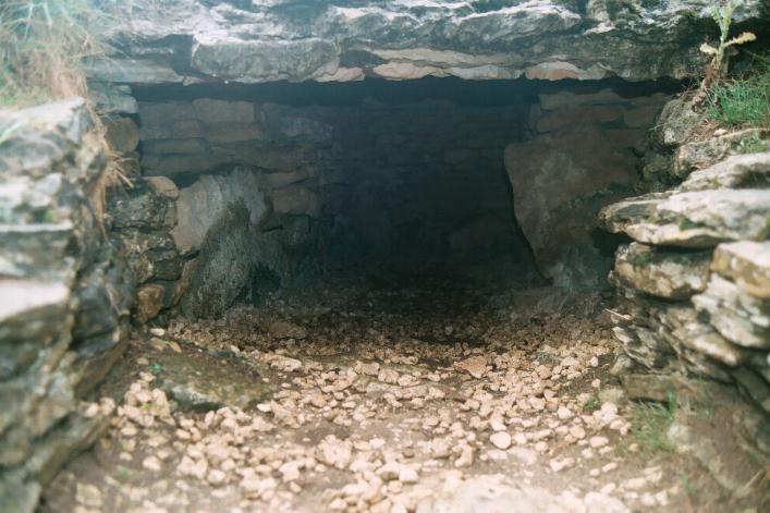
After about 15 or 20 minutes the Devil's Den came into view near the bottom of the gentle slope up to the left. As vegetation was thick, I missed the path where it forks left from the track 20 yards or so before the dolmen. The path itself was fairly overgrown and the dolmen in crop.
I slowly and gently made my way through the crop. Judging from the mess in places though, I guess others hadn't been quite so careful.
I love dolmens (!) and this dolmen is everything I expected, despite the slightly dodgy restoration or repairs. Having not visited France, Ireland, Wales, Cornwall or Devon for some time, it felt quite odd to be looking at a dolmen. But good!
Photographic opportunities were limited by the thick crop, but I enjoyed the peace of the site and felt fortunate not to be disturbed.
As I walked around the dolmen a couple of times with my camera, its positioning in the valley seemed unusual, as I now see Rhiannon has remarked on this site. It's placing did however remind me slightly of Lambourn Seven Barrows that I had visited the day before.
With freedom to wander restricted by the crop, having taken a few photos I soon returned to the overgrown path and continued towards the main part of Fyfield Down. Luckily the path soon entered another field and was no longer overgrown.
It also contained a very pleasant spot where a smallish tree is surrounded by sarsen erratics. Amusingly reminiscent of Lundin Farm stone circle in Perthshire! I stopped here to empty my boots of seeds, thorns, 'sticky-buds' and all manner of other vegetable-based detritus. When will I learn not to wear shorts when megaraking?
Jamming and polishing
As the path rises, the view of the numerous sarsen stones or 'grey wethers' littering the valley floor is very impressive. As I descended into the stones I had no idea how easy it was to find the Mother's Jam 'altar stone' Julian refers to. I found the one photographed by rebrickdream, if that's it!
 |
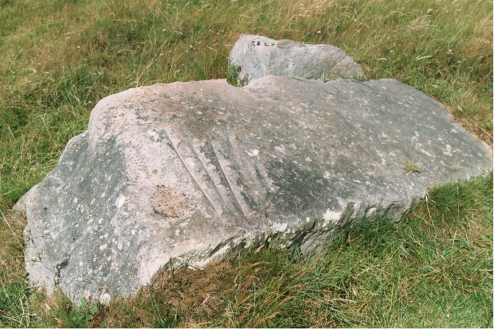
Rejoining the path a little further on, I went on to try to find 'The Polisher'.
 |
Sunday 27 July 2003
I know many people regard this stone as a kind of (un?)holy grail. And it wasn't exactly easy to find, even though I had gleaned a fair amount of information and hints from a few different sources.
Reading about it, it seems a very special place and I was very 'keyed up' about trying to find it, with slight misgivings about whether I'd be disappointed.
So is it worth the effort or is the chase better than the catch?
When I first approached the stone, I didn't think it was the one. It seemed smaller than in photos I'd seen and the way I approached, the corner with the grooves was farthest from me.
When I spotted the grooves I could hardly believe how insignificant the much sought-after stone looked....
BUT, the very moment my fingers traced the grooves, feeling how incredibly smooth they are worn, I felt a sudden connection to the people who used the stone to sharpen their tools and weapons.
And I'm not someone who usually feels that kind of 'nonsense'! For me, that in itself means this is a very special place.
How many people must have sharpened how many tools and weapons how many times to wear such long and relatively deep grooves in such hard rock?
(A question I couldn't help keep coming back to as I sat and pondered the stone is actually kind of banal, and will surely never be answered - why this stone…?)
Returning to the Ridgeway I found a group of 15-20 people on a guided walk. As I passed I couldn't help overhearing the guide talking about the Polissoir. He told the group they were going to see it. Very annoying for the people I know who've not been able to find it.
Pausing, I surveyed the scenery to the west and south for landmarks. It took me a few moments, but soon I spotted the top of Silbury Hill, confirming that the village I could see most clearly must be Avebury.
 |
 |
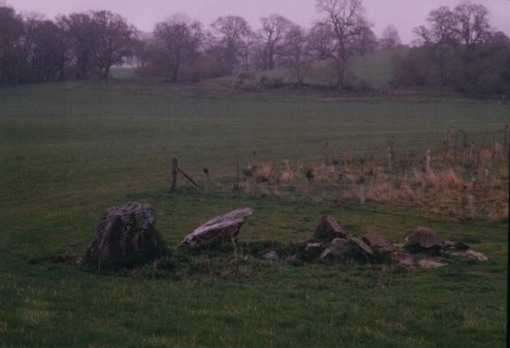
Galloping grey wethers, Mothman!!!!
I headed back down the path across the gallop towards Delling Copse, but kept along its southern edge to follow the Herepath east keeping an eye out for Long Tom. This is an 8 foot megalith Julian mentions on the Mother's Jam page of TMA as a possible iron age waymarker.
Long Tom is indeed tall and rather thin with a very square cross section. Almost looked more modern than iron age to me. Found in the unmanicured section in the middle of a horse gallop about 30 yards south of the Herepath at approximately SU144713.
I returned to the herepath for a short distance then headed south east, again alongside some gallops to the oval (horse?) track at Redpost Farm. Here I took a path leading south west but then bending round a field border after a few hundred yards to continue south east again.
I was rewarded with an interesting view of the Devil's Den in its valley as I descended towards it to retrace my steps to the car.
No Sanctuary
I drove off along the A4 to The Sanctuary. This is a site that has intrigued me for a long time, not least because I must have driven straight past it on my one previous Avebury visit around 8 years ago.
Sunday 27 July 2003
Just as enigmatic as I expected. After only a few minutes I decided it was too complex for me to get my head round, especially with other people wandering about. Need to sit down & read about it onsite and 'sans tourists'.
As a vantage point for spying out the landscape it's superb.
And worth spending time at for both reasons!
Unfortunately there were too many casual tourists about to really relax and take my time examining the site and landscape, so across the road I went, to Seofon barrows.
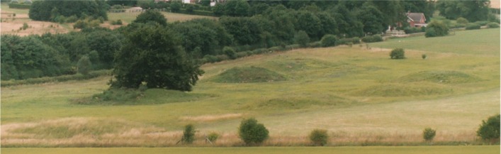
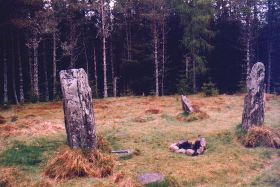
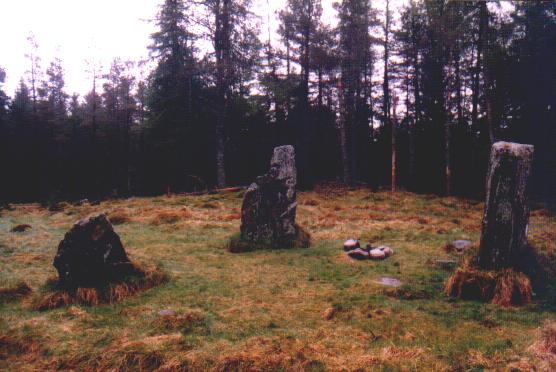
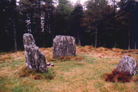
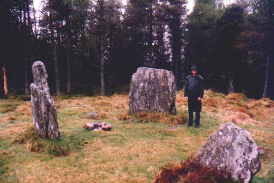
Sunday 27 July 2003
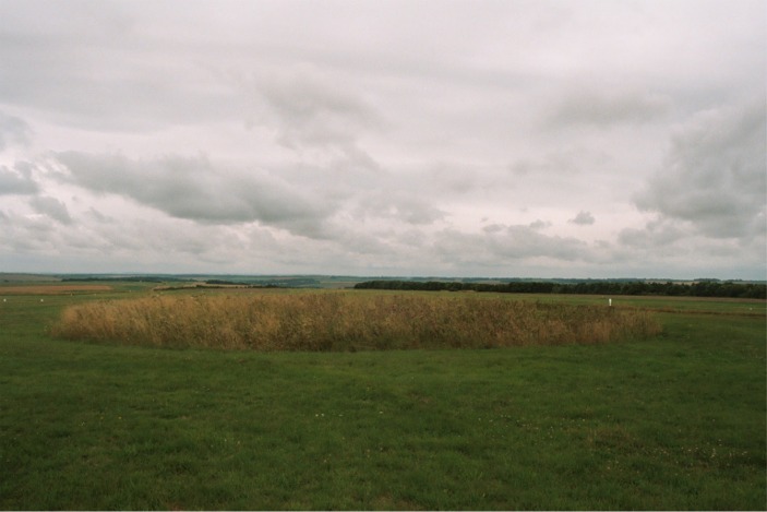
The barrows stand dignified and proud next to the busy A4 and the sunny Sunday afternoon bike-bustle of the Ridgeway. The three barrows featured in most pictures seem clearly to be the 'tip of the iceberg' here.
Julian remarks in TMA there were once maybe 12, and as you look on it's easy to believe and visualise. Given the relatively short distance to an 'outlying' barrow to the north and the interestingly-shaped 'tumuli' nearby, I'd not be surprised if it was more.
Crossing the A4 carefully - it's bend makes it difficult to see far, and avoiding the mountain bikes zipping about, it was back in the car and a quick left turn to East Kennett village.
Moth loses it in more ways than one
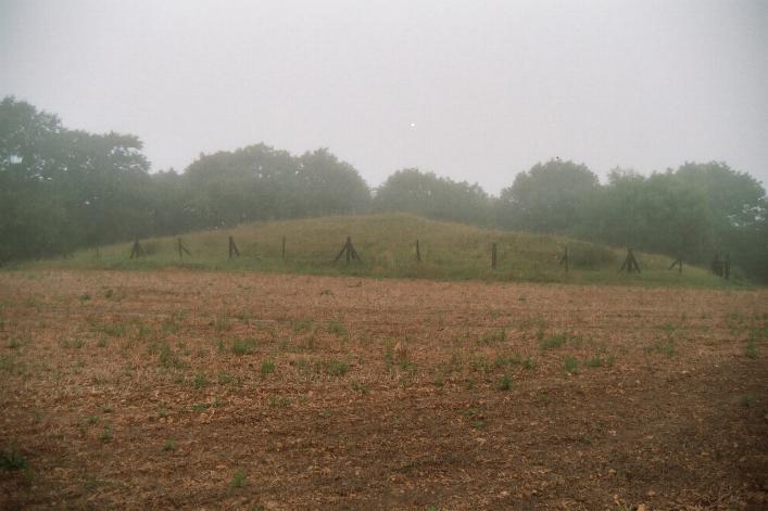
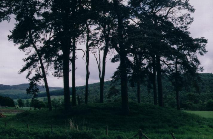
Taking a right in the village and parking just down from the church I walked up the lane and through Manor Farm joining a bridlepath up the hill to the west. The tree-topped East Kennett Long Barrow was clearly visible to my left.
Sunday 27 July 2003
Coming from the Sanctuary, I reached East Kennett village and took a right turn. I parked just down from the church and walked up the lane and through Manor Farm, joining a bridlepath up the hill to the west. The tree topped East Kennett Long Barrow was clearly visible to my left.
After a very short distance an overgrown but obvious track appears on the left, leading alongside the 'top' edge of the field where the long barrow stands.
As the path reached the field the barrow is in, there was no hedgerow or fence and the crop had nice wide, deep and clear tractor tracks.
I decided that should anyone disapprove, if I hustled along, the chances of me being spotted were slim. (I've now read that it's best to ask permission, so if I go again I will!)
Two minutes later I was on the north west end of the barrow amongst the trees. Reaching the top I soon found my way barred by impenetrable undergrowth thick with stinging nettles. I don't think I could've forced my way through, even if I hadn't been wearing shorts, As it was – no way!
I made my way back down to the foot of the barrow and turned right, along it's north east side. It was a struggle to make my way without damaging the crop and without stinging myself to death on the nettles that also line the edge of the barrow.
Reaching the south west end of the long barrow I found that there is actually some space to stand and look at this end. This 'felt' like the 'front' of the barrow, though I have no idea whether it is or not.
I couldn't see the chamber stones that apparently protrude at this end, but the vegetation was rampant, and once again of the stinging kind. Winter visit? Some brief but quite interesting info.
Leaving the south east facing end of the barrow there was a nice neat greenway track of mowed grass running at rightangles to the barrow. It was so clear and pleasant to walk on that I followed it off up the hill to my right, assuming it must meet the path I had left to reach the barrow.
My eyes scoured the hillsides to the south in an effort to spot some tumuli and perhaps the site of Little Avebury stone circle. Don't know if any of these are visible, but I couldn't see them.
I soon decided that it must be taking me too far west, so retraced my steps and turned north east(ish) following the edge of the long barrow's field. I had to walk carefully as the field edge was particularly uneven and I kept disturbing beautiful clouds of butterflies (no relations).
To my surprise my orientation still seemed to be wrong because although I still had the long barrow on my right, the path I was seeking still did not appear. I was kind of lost, but at worst could have just headed for the long barrow.
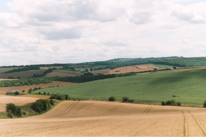
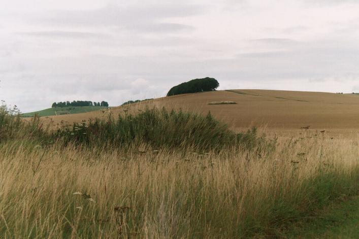
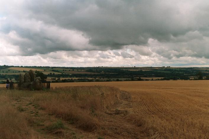
Rather than do that I decided to carry on. I was rewarded with an absolutely STUNNING and unusual view of West Kennett Long Barrow and Silbury Hill.
I have to admit I was so gobsmacked by the suddenness with which the view appeared (I just looked up from watching where I was putting my feet and it was THERE) that I absolutely 'lost it' for a few seconds.
I think this photo almost does the view justice.
At this point I was also able to bear north east with the field edge back towards East Kennett and the car, eventually meeting the path I'd been looking for, but from the opposite direction to intended! But what a detour!!! I returned to the car the way I'd come.
Final highpoints
Time now running short I shot off to Adam's Grave, and Knap Hill, before heading for home.
Sunday 27 July 2003
WOW.
Sorry. Just WOW!
Read all the other fieldnotes. They say it better than I can. Or read my Knap Hill fieldnotes which have a tiny bit more substance than this one!
But if I'd gone up Knap Hill first, I think that would've just been 'WOW!' instead….  |
Sunday 27 July 2003
I went up to Adam's Grave first. If you've read my 'fieldnotes' on that you'll know it rendered me practically speechless.
Knap Hill is hardly less spectacular, but without the barrow on top.
It somehow also felt less wild though. Both hills and the car park between were busy, but several people sat up here for some time, whereas nobody stayed on top of Adam's Grave for long while I was there….
The views from both just go on forever. Sorry to repeat a cliché but it's true. And from Knap Hill you can see the Adam's Grave barrow properly. It's strange and very impressive from here.
It must be really mind-boggling if you know the area well and can spot places you know. I'm still in awe over a week later.
Three an a half hours later I was driving into Leeds. I didn't hang about! It'd been a long but rewarding day. I look forward to my next trip to Avebury (September?) which must take in Windmill Hill, the Long Stone Cove and others. It's a hard life sometimes....
What a fantastic weekend!!!
|
Glos 'n' Oxon, Picnic People & Stomping in the Sun – Part 2
Part 1 is here
Picnic PeopleBefore the feast
Saturday 26 July 2003
After breakfast at my B&B between Uffington itself and the White Horse, I asked the pleasant (but a bit too huntin', shootin' fishin'-y) B&B lady if she knew where I might get an OS map of the area.
She reckoned the shop in Uffington would have one, so I headed off, also in search of some vittles for the picnic. Having arrived at the counter with my basket of unsurprisingly over-priced food, I asked about an OS map. They were expecting some….
So, not wishing to be rude, I still bought the gold-plated bread, cheese etc and zoomed off to Wantage. OS Explorer 170 purchased (I LOVE the Explorer series!) I had a few hours before the appointed hour for the picnic, so I headed for Lambourn Seven Barrows, via the Blowing Stone.
I visited the Blowing Stone once many years ago and it was exactly as I remembered it. In a word, 'odd'. No idea what it's doing there, no idea where it's come from, no idea what it may once have been and no idea if you can get a sound out of it. Unlikely. Well worth a look though.
Popping a quid in the 'upkeep' box, I jumped back in the car and headed up the hill along the B4001 towards Lambourn Seven Barrows.
As you decend gently towards the seven barrows, it's possible to play 'spot the barrow' to the left of the road. I even stopped at map ref SU324833 where there is a small overgrown barrow next to the road and a larger and neater one out in the field perhaps a quarter of a mile away, slightly back towards the Blowing Stone. This one was easily visible, as it too was covered in unmanicured growth.
I later noticed that the map shows a long barrow on the hill at the opposite side of the road here, at SY323833. Unlike me not to have noticed it on the map – that's what comes of not getting the map in advance I guess…. Curses!
Continuing down the road I managed to completely miss the seven barrows. Think I must have still been half asleep, because although they and their sign are harder to spot from this direction, they are so close to where I had just stopped, that I deserve shooting!
I won't go into detail, but I eventually realised I'd missed them, so I promptly misread the map completely and found myself going off on another road in a different direction….
Retracing my route, I was soon approaching the right place and from the South, I had no problem spotting the barrows and the sign for them (and the nature reserve they reside in). Plenty of grass to park on at the bottom of the hill, only yards from the barrows.
  |
26 July 2003
Fascinating site. Such a mixture of different sized and shaped barrows. And not set out in any pattern, yet seeming to fit together somehow…. Or maybe that's just me.
For some reason I can't quite put my finger on, photographs of this site have always particularly appealed to me. And I wasn't disappointed. It nestles near the bottom of the eastern side of a wide yet sheltered, gently sloping valley. I wouldn't personally use the word 'dell' as Treaclechops did in her fieldnotes, it seems more 'open' to me than what I would call a dell. No matter. A very pleasant place.
After spending 20 minutes or so walking up and down between the barrows I took a few photos from various angles, but didn't feel they were really 'working'. I meandered along the track up the hill past the barrows, but still couldn't find a view I was happy with, so I wandered back.
Studying the mounds for a few moments I looked around and behind me noticed that the very far corner of the field on the other side of the track gets up quite high.
The elevation looked like it might give a good shot with a big lens on, so nipping across a handy and sizeable gap in the fence, I strode round the edges of the field pausing only to pick up and study the odd bit of interesting looking flint. I soon gave that up when I realised just how many bits there were and matched that up with my lack of experience of worked flint!
Before I knew it I was in the top corner of the field and, fitting my 300mm lens, I had he shot I wanted…. Very satisfying! I've posted it here.
Having wandered around for a good 40 minutes and got the photos I wanted, I couldn't see any other places on the map that would be quick to visit so I decided it was time to head for the Uffington White Horse.
Arriving at the car park I decided I'd walk up to the Horse's head where we planned to meet. If nobody was there yet (as I was about an hour early I didn't expect much!) I would carry on up past Uffington Castle and across the Ridgeway to have a look at Idlebush Barrow Cemetery.
Sure enough there was nobody lurking in such a way to make me think they were TMAers, and Jane and Treaclechops certainly weren't there. (Of course it was impossible not to ponder whether just about everyone I passed was someone whose username I knew….)
So off I went up the hill, across the Ridgeway and onto the downs to the south….
  |
26 July 2003
Up the hill, passing the magnificent Uffington Castle enclosure or fort on my right, I reached the Ridgeway and followed it west for a short distance until a bridlepath appeared on the left.
Orientating myself with the wooded land marked on the map and what I could see on the land, I followed the slightly overgrown path for about half an hour at a pretty brisk pace.
This brought me to the twisting ribbon of woodland right beside the barrow cemetery.
A short distance across the down I could see what looked like the top of a barrow largely hidden by a dip perhaps. Ah. No dip. Not the TOP of the barrow then? The whole thing? Uh-huh.
Making a shape a bit like a little flying saucer sitting on the grassy plain, Idlebush Barrow itself looks to me to have been fairly denuded at some stage. Its outer edge is a very low embankment, with the small mound (less than 20 feet across, at a guess) rising only about 5 feet up from it. (Sorry if these guesstimates are way out, but what I'm trying to say is it's pretty small!!)
A little further on across the down is another barrow, this time almost completely ploughed out, but enhanced (or at least made more noticeable by the long reedy grass it is covered by. It is just about possible to make out a slight embankment surrounding it.
I've posted some photos of both. Retracing my steps and bearing west toward the strip of trees, I went back past both barrows looking for a 'tumulus' (another barrow really) marked on the map that I had missed.
Well, if it's there, I missed it on the way back too, and it must be virtually invisible. I suspect that to most non-experts like myself, it is effectively ploughed out.
A word of warning. Although they still look far from impressive, somehow my photos actually manage to make the barrows look more appealing than they seemed at the time…. Don't get your hopes up!
Approaching the Ridgeway on the return route, I was rewarded with excellent views of Uffington Castle, and once back across the Ridgeway I climbed the bank to look out onto the centre of the fort's enclosure.
Merry meetings
Back to the car to pick up my 'picnic' and then to the horse's head. Couldn't see anyone until the last moment, then there were Jane and Treaclechops with Miriam – all of who I was expecting to see (though I didn't know what Miriam looked like).
With them was a slim distinguished-looking chap wearing glasses and a white baseball cap. Quick introductions revealed this to be Jimit. And Treaclechops' welcoming hug proved me to be "Yuuuuchhhh…all sweaty!!!"
I fluttered (or thudded) to the ground beside them and lay back on the ground listening to the conversation and banter. I could immediately tell it was going to be a good day.
I continued to lay splayed on the cool grass for a few moments to relax and allow my internal thermostat to kick in – the speedy walks to Idlebush and back, followed by the car park and back had been fairly strenuous. Then, propping myself on an elbow I joined the 'party'.
To everyone's delight, Jimit produced a bottle of fizzy stuff, the cork flying high into the air over the White Horse's head before being retrieved. Very pleasant stuff to drink this. Can't remember what it was called. Lemonade was it? No that's not right….
Seriously classy fella, that Jimit.
Before long we were joined by the softly spoken and bearded Baza accompanied by his quiet smile. Baz had met Jane and (I think) Treaclechops before, and after Miriam, Jimit and I were introduced to him, the group was complete for the moment.
Chasing the Dragon
After we'd all chatted for a while, Jane asked if anyone had ever walked down to Dragon Hill. Surprisingly none of us had, and amazingly, neither had the locals – Jane and Treaclechops!!
As we were still expecting Ocifant & Mikki and possibly Goffik, (as well as anyone else who might turn up) we made the trip in shifts.
Baz, Jimit and I made the first approach, unanimously dreading the return climb before even reaching the road between Dragon Hill and the White Horse.
Lots of shaking of heads and stroking of beards followed the short ascent onto Dragon Hill as we pondered whether this was the spot for Brigantesnation's shot of the horse. A recurring theme for the rest of the day.
The answer was generally held to be 'no' though I was probably inordinately keen on the picture my imagination produced of BN teetering at the top of a step ladder holding the camera above his head to try to get the horse's head in….
Soon we turned back to be greeted by Jane who was making a typically non-conformist between-shifts trip to Dragon Hill. Treaclechops and Miriam made the trip a little later.
An Ocifant arrives
By the time we got back to base camp, Ocifant had arrived from his adventures recounted elsewhere. Greetings were hardly made before Jane also returned to the fold.
It seemed everyone was probably there, so I thought it was time to prove my Scottish Megarak credentials by producing Bakewell tarts and almond slices for everyone. Some people eventually even ate a few….
After a while Ocifant went to check whether Mikki felt able to tackle the hill, but she decided not to and he returned to the rest of us.
The first sets of group pictures were duly taken, and around this time we saw the emergence of Sarnt-Major Treaclechops as she spied some unobservant teenagers wandering along the chalk of the horse's back.
All I heard before my ears lost sensitivity was "EXCUSE ME!! EXCUSE ME!!!!!!" as TC flew down the hill in a frenzy of righteous indignation that a national treasure was being abused.
I'm told she followed this up with "DO YOU KNOW THAT'S AN ANCIENT MONUMENT YOU'RE WALKING ON???!!!" (not a phrase one gets to use often) but I was too busy nursing my ringing ears to hear. Suffice to say the hapless youths shifted their asses fairly damned pronto…
Smokin' at the Smithy
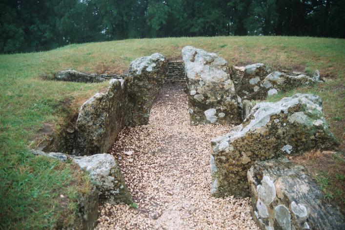
After more eating, chatting and photo taking, we decided to go and join Mikki and if she felt like it to have a trip by car convoy to a lane that Jane knew that gets you pretty close to Wayland's Smithy. Mikki was game, so off we went – Baz finally giving up on the legendary 'Brigantesnation Horse Shot' (for now!).
Once at Wayland's we made ourselves comfortable under the trees opposite the entrance to the long barrow, Jane settling down with her sketchbook.
Various forays were made around and into the barrow, Jimit wandering into the chamber with a 'rollie' dangling from his lips bringing a cry of "DO YOU KNOW THAT'S AN ANCIENT MONUMENT YOU'RE SMOKING IN!!!"
I think just about all of us went to observe the phenomenon that Jane has mentioned, that although the barrow tapers towards the back, it tapers exactly the amount to make its sides appear parallel when viewed from behind.
And do you know what? She's right. It's quite a striking effect once you see it – surely deliberate!
After conducting a group lecture to an unfortunate couple unwise enough to ask one of us a question about the long barrow, with much giggling we posed ridiculously amongst the entrance stones for some group photos. Luckily for them, the hapless couple had got away by then, or they would probably have been roped in too.

A little more 'chilling' was cut short by some real threats of rain, and much to the delight of Treaclechops and myself, we set off in convoy for The Eagle Tavern in nearby Little Coxwell.
'Blonde moments' and beer moments
After a couple of minutes we were brought to a halt as local girl Jane, the 'not at all dizzy but rather intelligent and sassy' blonde driving the lead car realised she'd gone completely the wrong way….
The 'up' side was that as we turned the cars, we finally found a view of the Uffington White Horse where you can actually see it's head…. Unfortunately the weather and the lack of a 600mm lens made a really good photo impossible. Another day maybe?
It still wasn't as good as Brigantesnation's shot.
One more 'blonde moment' from Jane (as she likes to call them – makes a change from "I'm an artist….") caused another mass u-turn, but having stolen Ocifant's map she managed not to get lost again!
Jane's defence spokeswoman said: "Jane was overcome with excitement at having visited these splendid ancient monuments with such an enthusiastic group of persons. It is this, coupled with the riotous singing occurring in her car, which caused her to experience temporary loss of concentration on the lanes she actually knows very well. No further comment....
Twenty minutes outside the pub in the rain waiting for it to open passed like… twenty minutes outside the pub in the rain waiting for it to open. And then we were firmly ensconced supping or sipping our respective tipples while chatting happily.
Time flew and after about an hour we were sorry to find it was time for Ocifant and Mikki to depart. Maybe another hour later, Jimit headed for home and his local boozer.
Soon stomachs were rumbling and resisting the temptations of the Eagle's menu, we jumped into cars to follow Jane to a great chippy in Faringdon. I WON'T mention that she got lost there too (oops!), but will say that the chippy WAS pretty damn good.
Jane's defence spokeswoman continued: "We've already seen how Jane was overcome with excitement: it is this, coupled with the fact the planners have changed the one-way system in the town which caused her to swerve and swear so violently in her quest for the chippery. No further comment....
Back at the car park, farewells and pledges of further meets were made, then we all headed off, me back to the B&B.
Lying on the bed planning my trip for Sunday I reflected on what a great bunch of diverse people I had just spent the day with, and was full of wonder at the incredibly mellow and good-natured bond that seemed to have sprung up spontaneously between us all. I silently thanked TMA for bringing us together.
A real shame about those who wanted to come but couldn't make it.
Part 3 is here
|
Glos 'n' Oxon, Picnic People & Stomping in the Sun – Part 1
Glos 'n' OxonNow I know how Dr Foster felt….
Friday 25 July 2003
Making the most of a trip to meet up with TMA folk at the Uffington White Horse picnic, I booked a couple of nights in a B&B farm near Uffington.
Taking Friday off work I set off for Gloucestershire in the rain. The plan was to have a look around Glos, make my way back up into Oxfordshire taking in various sites, to quickly visit Jane's house for a cuppa, and finally head for the B&B.
I hadn't been bargaining on rain, but I'd been looking forward to this weekend for long enough that I was able to forget the weather and what felt like the beginnings of a cold.
By the time I reached Gloucestershire it had poured all the way and the rain was coming down even harder if anything.
Hetty Pegler's Tump was my southernmost target, so approaching on the B4066 from the north I passed the car park at Coaley Peak where the remains of Nympsfield Long Barrow lie, planning to visit after turning north from Hetty Pegler's.
I found the parking place for Hetty Pegler's, parked up and followed the signpost up to the barrow.
25 July 2003
Spotting the signpost for Hetty's pseudonym 'Uley Long Barrow' on the right, I pulled into the tiny layby, discovering that at the moment at least there is a nice flat piece of grass just inside the field behind where it looked as if people had been parking.
I parked the car and got out. In the time it took me to put on my coat I was pretty damp. I walked a couple of hundred yards in the direction the signpost pointed but the path petered out.
Retracing my steps twenty yards or so, I noticed a slight gap in the hedgerow that had been on my left and was now on my right (if you see what I mean). I stepped through and, as I hoped, to my right stood the long barrow which had been hidden from my sight by dense summer vegetation and filthy weather!
Oh for a sunny day to visit! This must be a pretty wonderful place when the water isn't seeping down your jeans and you don't have to have your camera stuck inside your jacket, digging in your chest.
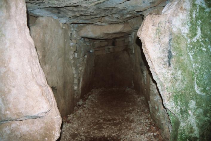
I just managed to keep my knees clear of the growing puddle as I squeezed through the entrance into the central passage. Immediately I'd got in I realised I'd done it again…. I'd left my torch in the bloody car!!!!
I knew from experience that this would probably also scupper my chances of getting decent photos as I wouldn't be able to focus in the dark….
Squatting in the now dampening chamber I could immediately make out the layout and construction of the passage, the remaining chambers on the left (south) and where the destroyed chambers would have been on the right (north).
As my eyes became accustomed to the dark, the light seemed just good enough that I tried focusing manually and fired off a couple of decent shots. (I haven't uploaded them as they are too similar to the pictures already included on the relevant page of this website.)
I love seeing ruined barrows and burial chambers, but there really is nothing quite like being able to get inside these things! I often refer to ruined ones being like a 'cutaway' or 'exploded' diagram, but as the stones of the passage and chambers are visible from inside you still get a clear picture of the construction.
It's especially nice to find the peace and feeling of well-being which seems, from comments on this site, to be universally felt here. I even sat in the blackness of the south-eastern chamber for a few minutes, unusual for me – not because of any misgiving about the dark, but because I'd usually rather be moving and looking and poking!
As I walked away, leaving Hetty Pegler's behind, I found that the rain hadn't abated and seemed somehow to be managing to fall heavily and hang in the air at the same time….
I hurried back to the car and after a few deep breaths and curses at the weather gods, set off the few hundred yards back up the B4066 north, to park at Coaley Peak and the ruined Nympsfield Long Barrow.
  |
25 July 2003
No ice cream van in evidence today in the filthy weather, I soon realised that I had misread the Landranger as to where the barrow is. As you drive up the short entrance road to the car park, the barrow is on your right as you turn left into the car park proper.
I drove round the car park (one car in residence) and parked as close as I could to the barrow. I still got drenched. In almost any other place this would be a nice enough example of a long barrow, with just enough of it left to make it easy to visualise. But other than out of convenience or completism (guilty) with Hetty Pegler's Tump just next door, there's not really much reason to bother.
The picnic area probably has nice views on a clear day and you could enjoy a nice ice cream though. I wouldn't know – couldn't see for the mist and rain….
The picnic area the barrow sits in probably has great views on a clear day and there's often an ice cream van it seems, so you could enjoy a nice ice cream. I wouldn't know – couldn't see for the mist and rain….
Today I was 'passing' on the nearby Longstone of Minchinhampton and Windmill Tump as I had visited both before, albeit several years ago.
Instead, my next call was to attempt to find the mysterious fieldmarks spotted by TMAer Minchin Hampton on a multimap.com aerial photograph of Inchbrook, off to the east. Map ref SO826021.
Into the labyrinth
The area giving access, however, proved to be a regular rabbit-warren of hilly, stone-lined, single-track residential village roads. After navigating my way around for about 20 minutes, reversing or diving frequently into passing places for other traffic, I thought I had a 'handle' on how to get to the possible site.
It was as I headed down the hill towards Inchbrook itself to turn round, that I met a van coming up the hill. I'd just passed a wide driveway so began to reverse. I found that I could see nothing in my passenger side mirror because of the rain and bad light under the trees. I then found I could hear a slight scraping noise…! It was the wall and my passenger door….
Having re-manoeuvred out of the way I cursed loudly and colourfully, wishing Mr Hampton and other interested TMA parties luck in their quest for information on this possible site: "You're the soddin' local, you go and have bloody look!"
Revving angrily I started off towards Belas Knap near Cheltenham. I noticed the signs to Cold Slad village. I remembered that in the big papery TMA it says go past and find Crickley Park for the 'prehistoric site' of Cold Slad. I thought about it, but given my mood, and the fact that half the attraction is meant to be the view (pah! Did I mention the rain?) I accelerated straight past the lot!
(Shame really, as I now notice there are no fieldnotes for this site. Still, I doubt if mine would have been very constructive or informative as I was fed up AND wouldn't have been able to see a thing!)
Calm, calm, calm
Like Kammer, a look at the map showed me the shorter and simpler path from the west up to Belas Knap. And, guess what? Just as I arrived THE RAIN STOPPED. As I walked the few hundred yards up the gentle hill, THE SUN CAME OUT! And very soon I recognised the grassy mound of BELAS KNAP.
25 July 2003
Like Kammer, a look at the map showed me the shorter and simpler path from the west up to Belas Knap. Encouraged by his fieldnotes and in view of the weather conditions I drove round the lanes to the north of the long barrow, through the farmyard at the end of the tarmac and up the unmade lane.
All was just as Kammer describes but it is a measure of my mood having bumped the car earlier, that I drove that far. If reasonably practical I usually leave the car outside farms and go and ask permission, walking from the farm!!!
As I pulled up at the bottom of 'Kammer's path' I found it now has a signpost, so I knew I'd got it right. Which was a relief.
Kind of bigger than I expected, it must have been a long time since I read a description, as I had forgotten (if I ever knew) about the chambers being 'open' through the sides of the barrow. Though I did remember that the apparent 'main' entrance was a classic 'falsie'.
After rolling around on the wet ground photographing the low lintelled south-eastern chamber, I stood up and just took in the scene. For the first time, the day was living up to my expectations fully. The frustrations of Inchbrook were forgotten as I stood in perfect peace. Not a soul….
I spent a good half hour chilling in the perfect peace up at the long barrow before hitting the path back to the car. On reaching the car I was even reasonably calm when I saw the big white scratch along the door. "With luck the metal itself isn't damaged…." Hmmm.
On to Oxon
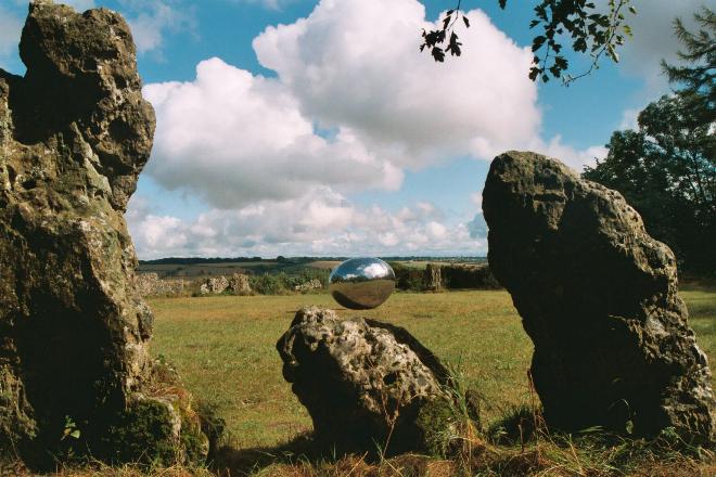
Next stop the Rollright Stones and Anish Kapoor's art 'installation' – not stopping on the way at Notgrove Long Barrow despite passing immediately beside it. (I've visited it before, and while not quite as negative about it as some others on this website, I don't think it's worth more than one visit!)
Regulars will know that I voiced strong reservations about Kapoor's piece of art. Not from an artistic, aesthetic or conceptual point of view, but from the point of view of someone seeing the Rollrights for the first or only time – visiting from abroad perhaps.
My thinking was that if I'd arrived at say 'La Table des Marchants' for my only visit (probably) ever, and found a big chrome blob in the middle of it, I'd have been irritated, annoyed or even upset.
Well. Ahem. Let's just say I stayed for an hour and took a few photos. Just the 19….
 |
25 July 2003
Regulars will know that I voiced strong reservations about Kapoor's piece of art. Not from an artistic, aesthetic or conceptual point of view, but from the point of view of someone seeing the Rollrights for the first or only time – visiting from abroad perhaps.
My thinking was that if I'd arrived at say 'La Table des Marchants' for my only visit (probably) ever, and found a big chrome blob in the middle of it, I'd have been irritated, annoyed or even upset.
So was I right? Or were the more artistically minded folk around these parts right?
Well. Ahem. Let's just say I stayed for an hour and took a few photos. Just the 19….
The 'sculpture', if that's really the right word, is somehow unobtrusive, despite being quite big and finished with brightly polished chrome! I guess it's because the Rollrights is a pretty large circle.
Yet it draws you in. And you find yourself playing games – looking at the reflected stones, trees and countryside. Watching the clouds. Watching the light change. Looking at your own reflection. Standing up. Squatting down. Walking away. Walking back up to it. And great fun to try to capture all this on film!!!
The weather for my visit also made the experience particularly interesting. The sky was dull as I arrived and the chrome looked almost dirty. I quickly realised though that it was actually just refraction of the dull sky from the tiny water droplets left on the highly polished surface by the rain.
As the sun emerged, the whole character of not only the circle, but the sculpture too, changed in unity. The previously dull metallic 'blob' was now dazzling with intense reflected sunlight, still refracted by the tiny rain droplets. Stunning.
Count me as a convert. But there wasn't a quintessential dichotomy in sight. Unless it was behind one of the stones.
I believe it's still there for a few more days. GO!!!
Quick trips to The Whispering Knights and The King Stone and I was on my way to the Enstone Hoarstone.
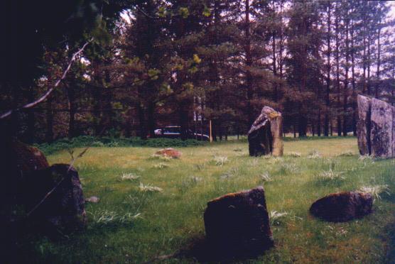
Enigmatic Enstone
What would I do without Kammer? Once again his directions helped immensely as, even with the Landranger, I could easily have missed the stones in the relative darkness of the little corner of the wood they occupy.
They really are very difficult or impossible to spot from the B4022 and it isn't until you take the turn-off right beside the wrecked burial chamber that you can see them. Even then they don't exactly leap out at you when the trees are wearing their summer foliage!
25 July 2003
These stones really are very difficult to spot from the B4022 and it isn't until you take the turn off right beside the wrecked burial chamber that you can see them. Even then they don't exactly leap out at you with the trees wearing their summer foliage!
The stones retain a power and atmosphere of their own despite being so ruined that I found it difficult to picture the site as a burial chamber and without the trees. Can't honestly say I could even see the orientation myself without looking it up.
The stones retain a power and atmosphere of their own despite being so ruined that I found it difficult to picture the site as a burial chamber, and without the trees. Can't honestly say I could even see the orientation myself without looking it up.
OK. Final megalith of the day was to be The Hawk Stone, so beloved of TMA's clothed (and unclothed) Oxfordshire contingent.
Keep your kit on Moth
Sighting interesting cloud formations to the north, I trod on the gas, hoping for a dramatic backdrop for photographs. Unfortunately, although I arrived at the village of Dean pretty quickly and I found the stone easily after a short walk, the opportunity for dramatic piccies had gone.
25 July 2003
Approaching Chiddington from the east, I turned right for Dean. Arriving at Dean, there is a bench set on a verge, where I took an immediate left. After a good few hundred yards this lane bends fairly sharply right (you can see where I mean even on a road atlas).
Right where the road turns there is a footpath signposted heading more or less straight on across the fields. Parking here would have been inconsiderate so I carried on to the next junction and was pleased to see that if I turned right (continuing a loop back towards Dean) there was a small layby.
Walking along the lane back to the footpath described, I realised I could see the Hawk Stone projecting above the horizon on my right. I simply followed the path and couldn't miss the stone, standing alone in deep crop.
Luckily, distinct tractor tracks enabled me to cross the crop to the stone itself, though photographic opportunities were limited. I still took several pictures hoping that what remained of the interesting cloud formations would add to the atmosphere, but alas, it proved too late.
Deeply textured and looferlike in it's surface – in a similar way to the stones of the Rollright Stones, King Stone and Whispering Knights etc, the single stone is also a bizarrely shaped beastie. (See Rhiannon's 'Folklore' post on the Hawk Stone page.)
This is one of those single stones that in my opinion calls into question Aubrey Burl's assertion that single standing stones were usually originally part of a bigger setting. I find it difficult to reconcile the size and proportions of the stone with a burial chamber, yet neither does it fit the style of the Rollrights circle.
Perhaps it's one of the exceptions. It certainly looks right on its own and I couldn't imagine how it would look any other way.
After spending half an hour or so at the stone, I headed for my final stop of the day – that well deserved cuppa at Jane's house, which I was relieved to find easily!
Warm welcome, amazing art and great company. What more can I say? Thanks Jane! But after a happy couple of hours, I had to reluctantly be off to Uffington to find my B&B. Picnic tomorrow.
Part 2 is here.
|
Delerious in Derbyshire
Painting is PANTS
Friday. Planning to paint my garden fence – ugh! – on Saturday, I reckoned I'd be due a reward on Sunday. So I rang the lovely (?) Ginger John to see if he had any plans.
I was disappointed to hear he was otherwise occupied. But I said (and meant it) that it wasn't a problem and I'd go on my own. To Derbyshire. John said he'd ring me if his plans changed.
Saturday. Mid-fence painting, the Mothphone rang and it was John. His plans had changed and he was free.
Good stuff!! John and I seem to work well together – I don't think so far that there's been any stone we've looked for seriously and failed to find. Helps that we're both stubborn gits.
As John lives in South Leeds and I'd be 'passing' on my way to the M1, we arranged for me to pick him up at 10am Sunday. This was good since when he stays over here for an early start we always end up setting off with bad heads.
Back to the painting and with some new motivation, the hours and hours and hours of dip, drip, wipe, splash, stroke, stroke, stroke passed like... hours and hours and hours. Five flamin' hours in total.
Still, topped up the tan nicely and got to listen to loads of groovy music! Could even hear the stuff I was playing at times over the neighbours blaring the sound of wonderful bleeding radio one....
Spent Saturday night checking out Burl, big papery TMA, and of course this site for ideas for the trip.
I knew I wanted to see Doll Tor and Nine Stones Close (no OS map on one previous visit and no time on others). I also wanted to pop into Arbor Low to take some pictures as I can't find the ones I've taken before.
So with the unwitting help of Stubob, Serenissima and other TMAers, I created a nice mess of biro on my already well-scribbled Landranger 119. Sorry to the maporaks. You know who you are.
There were so many 'possibles' that I didn't really plan a route, other than deciding to start with the ones I really wanted to see.
Bloody Sunday drivers!
Sunday 13 July 2003
Arriving at John's house, I discovered that we may not be totally headache-free after all, as he'd been out to the pub for 'a few' the night before. I was fine though, so that's allright.
John was happy with the plan – or couldn't be bothered to argue, so we headed off for junction 30 of the M1.
Which of course we proceeded to miss because of some particularly intriguing 'applied bollocks-talking'. Probably something incredibly intellectual like "Why are Derbyshire 'Lows' actually high?"....
Still, junction 29 isn't far and we didn't lose much time by hitting Chesterfield (it's got a crooked spire...) from that direction.
In fact we soon realised that the direction of approach was fairly incidental – a sunny Sunday morning wasn't it? The roads through Chesterfield were full of bloody daytrippers!
Could've been worse. We stopped for petrol anyway.
Earlier on John had mentioned that he'd brought no food, but I'd happened to have plenty of bread rolls and cheese in at home (mmmm, cheeseez) so I'd brought enough for both of us.
I was surprised then, when John came out of the petrol station armed with the largest Cornish Pasty I've seen this side of Padstow, which he proceeded to demolish for 'breakfast'. As is fairly usual for me, I'd had no breakfast. Despite the meat, it made me quite hungry. I also found a chunk of it in the car yesterday. Thanks John.
So is it Youlgrave or Youlgreave?
Heading off towards Stanton Moor and Birchover we were zipping along the B5056 when we arrived in Youlgrave. Where's the 'e' gone then?
I've never noticed before, but on the OS map and my road atlas it's Youlgreave, but the sign as you enter the village says Youlgrave, as does the blind above the window of the post office! Weird.
I'll call it Youlgrave. I'm sure the people who live there wouldn't put up with incorrect signs for long! Lovely place whatever it's called – spent a couple of nights there once. Great pubs.
Any road up, we'd established that we needed to turn off before Youlgrave, so we turned round. To be fair to the Ginger Navigator, even when we retraced our steps it wasn't very well signposted. I was a bit surprised I didn't recognise it actually.
As we approached Birchover I told John about 'the Druids Inn' and its delicious food and massive menu. (I assume it still does delicious food and has a massive menu, not having been for a few years.)
I pointed out Rowtor Rocks, but as it was noonish already, thanks to traffic and wrong turns, we gave the outcrop a miss. Having been onto the rocks before however, I'd highly recommend the steep but easy climb. Stunning views.
Up the hill towards Stanton Moor then.
Going over to the other side
Stanton Moor 'proper' is a wondrous place, littered as it is with all manner of prehistoric phenomena. The Nine Ladies are almost irresistible.
But resist them we did. We had both visited before, more than once, and the number of cars parked in the laybys mentioned in Elderford's Doll Tor fieldnotes suggested that we would have to fight our way onto the moor anyway!
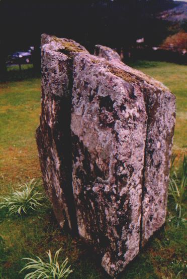
So, out of the car we turned our attention to the left of the road from Birchover towards Stanton in Peak. As we walked up to the second layby (on the left) we immediately spotted the Andle Stone in its dinky enclosure.
My god, it's enormous (darling)!
We were soon standing at the foot of this benign monster. The big papery version of TMA says it's 15 ft long, by 10 ft wide and 10ft high. Pah! Pah! and thrice Pah! with multiple exclamation marks!!!!!
See Andle Stone fieldnotes below.
Doll Tor beckoned.
Living Doll
As we followed Elderford's splendidly detailed instructions from the Andle Stone (thank you Mr E), John realised that he'd looked for the beautiful Doll before, but hadn't known her name. And hadn't found her.
See Doll Tor fieldnotes below.
Retracing our steps, John and I were both so invigorated by Doll Tor that we took our courage (!) in both hands and climbed the Andle Stone. And WOW!!!! Is it worth it?!!!!!! Hell yeah!
Back at the layby, John (who's a bit of a Mini fiend) and I (60s and 70s car fiend in general) stopped to admire a very nice Riley Elf.... Sorry. 'Oi'll get me anorak.'
As we passed back through Birchover it was very tempting to stop for a lunchtime pint at the Druids or Red Lion. We wanted to crack on though, so back to the B5056 we went.
Arriving at Elderford's layby at 119 229 619, we discovered it was full. But luckily there is room for one car at the bottom of the lane on the west side of the road. This is right by the gate to the track leading up the hill towards Robin Hood's Stride, Cratcliffe Rocks etc and Nine Stones Close.
Over the hill and round the bend
We didn't stop at the Hermit's Cave as there are far too many really old stones in Derbyshire to bother wasting time looking at medieval holes! (I guess it may well have been significant before that really, but I liked the phrase!)
The track bends left as it approaches Robin Hood's Stride directly towards the craggy outcrop, leaving Cratcliffe Tor (as I believe the outcrop with the hermit's cave is called) behind to the right.
Robin Hood's Stride is pretty impressive, but we weren't going to bother climbing it (too hot!). We kept to the track, not taking a footpath to the right which I'd guess goes out onto the top of Cratcliffe Tor.
See Robin Hood's Stride and Nine Stones Close fieldnotes below.
A big bouncing beauty
Nine Stones Close caught me off-guard both by the fact that we looked virtually straight at it without seeing it and by the fact that it was somehow not as I had imagined it.
See Nine Stones Close fieldnotes below.
Back at the car, after a quick gulp of rehydration (weak Ribena Toothkind stolen from my little boy Callan – the only plastic bottle in my house) we sped off to Arbor Low.
Shoot your shot
Since it was now about 1.15pm, we briefly thought of leaving Arbor Low until later in the day, just before heading back to Leeds, in the hope that there would fewer people around. Trouble was that just about everywhere else we were thinking of going was in the opposite direction.... And so is the M1. I bit the bullet.
See Arbor Low fieldnotes below.
On the way back through the farm we noticed that some big renovation or conversion work is going on, and observed how nice it would be to live there. We both thought we'd try to get the path moved so that people weren't traipsing past the house all the time though!
Raven raving
Back at the car we decided we really ought to eat, but didn't want to sit in a car park to do it.
I had been captivated the night before by Stubob's pictures and descriptions of the Raven Tor cairns, so with John's agreement, we decided to forego the Barbrook circles (which I've seen before but John hasn't) and Eyam Moor (which I've explored unsuccessfully....)
They could form the basis of another trip and we would instead direct our attention to Raven Tor and Beeley Moor. So we headed off back through Youlgrave (for the fourth time!) and Rowsley, to find the entrance to Stubob's disused 'Wragg's Quarry' and Raven Tor.
See Raven Tor Triple Cairn fieldnotes below.
Back at the car, we perched in the shade of the open hatchback and finally remembered to get around to lunch. I think it was about 2.45 or 3pm, and the Wensleydale had the sweats badly!!!! Still delicious though. Stealth cheese, Wensleydale. Wonderful stuff.
No pudding! Aaargghh!!!! Oh well, can't be helped. Next stop Beeley Moor, primary target – Park Gate stone circle. Secondary targets, more cairns.
Pudding!!!!!
We arrived at the bottom of the lane leading north between forestry and nature reserve, towards the various cairns and stone circle. Imagine our pudding-deprived delight at the sight of an ice cream van parked in the wide entrance to the lane!
'Magnum' for John and large '99' for me and off we trotted.
See Park Gate Stone Circle fieldnotes below.
Some like it hot...
And that includes me! But it was now well gone 4pm and the several hours under the blazing sun and a fair distance stomped were beginning to take their toll on both of us. And we still had the 'sunny Sunday' daytripping traffic to negotiate.
So, despite the proximity of the cairns, their attractions were narrowly outweighed by the proximity of the Devonshire Arms in Beeley for a quick pint of Black Sheep Special before the drive home. It was the right decision. Very pleasant way to end the day.
  |
Sunday 13 July 2003
Out of the car we turned our attention to the left of the road from Birchover towards Stanton in Peak. As we walked up to the second layby (on the left) we immediately spotted the Andle Stone in its dinky enclosure.
We were soon standing at the foot of this benign monster. The big papery version of TMA says it's 15 ft long, by 10 ft wide and 10ft high. Pah! Pah! and thrice Pah! with multiple exclamation marks!!!!!
The proportions sound about right, but absolutely NO WAY is it that small! You can call me Susan if it's not so. As Droood remarks in his fieldnotes, you need to stand on the pile of rocks to even reach the first handhold! And John's over 6 ft!
Julian must have had on some serious platforms that day!!!!
I reckon it's more like 17 or 18 ft high. Possibly more than 20 ft. It was more than high enough for me to give the climb a miss and for John to just climb up the side but not get on top!
It commands a beautiful view of the wide valley to the north-west. Blessed with such a clear and sunny day, we were spellbound.
Retracing our steps from Doll Tor stone circle later, John and I were both so invigorated that we took our courage (!) in both hands and climbed the Andle Stone after all. And WOW!!!! Is it worth it?!!!!!! Hell yeah!
Sod the cupmarks (sorry) and Victorian etc graffiti… FEEL that view and sense of importance!!!!! The extra elevation and adrenaline add so much…
BUT, a word of warning: unless you're pretty confident with heights, don't do it! Certainly not on your own! The turn back over the edge to climb down is very awkward, as it's very difficult to see over the edge and know what you are doing.
With us, John went first, and although he had to negotiate his own 'sticky' moment or 2, was able to help direct me from below. But it was extremely touch-and-go as far as this Moth freezing solid with fear is concerned!!!!!
Definitely plenty more than 10 ft. Blimey, even I could 'dangle & drop' or at a push maybe jump 10 ft.  |
Sunday 13 July 2003
As we followed Elderford's splendidly detailed instructions from the Andle Stone (thank you Mr E), John realised that he'd looked for the beautiful Doll before, but hadn't known her name. And hadn't found her.
I'm full of (figurative) disbelief and (real) awe that Jane found the Doll Tor circle without a decent map! It's almost spooky. I reckon with the Landranger on its own I might have missed it and I'm not bad at following maps.
What can I say that hasn't already been said? An immensely beautiful (now) sylvan voodoo Doll(y) casting a spell on all who see her.
I've said that there's 'always' something about sites when I see them for myself that surprises me or at the very least adds to the experience. In the case of the 'living' Doll the surprise was threefold.
The 'lesser' surprise was the cairn, which I knew about but was bigger than I expected.
The 'middle' surprise was that at least 2 or 3 of the actual stones seemed to have been repaired – I knew the circle had been restored and it's not a problem for me, but I don't remember anyone explicitly mentioning it.
And the ' big' surprise was the view to the north-west!!!! I never realised you could see through the trees and thought I'd have to try to make the trees disappear in my mind as at so many 'newly' forested sites.
None of it!!! Looking closely at some of the photos here in retrospect, it is possible to catch a glimpse. I took a couple of photos trying to emphasise it but I'm not sure it worked….
It's wonderful when a 'new' bunch of rocks lives up to high expectations. Doll Tor managed that and more! Phew!!!
Oh yeah, John liked it too.
Retracing our steps, John and I were both so invigorated by Doll Tor that we took our courage (!) in both hands and climbed the Andle Stone. And WOW!!!! Is it worth it?!!!!!! Hell yeah!   |
Sunday 13 July 2003
On the way back to the car from Nine Stones Close stone circle, I quickly sprinted up Robin Hood's Stride to see if it was worth an 'elevated context*' snap of my now beloved Nine Stones Close, as I had a 300mm lens with me (it wasn't).
*I just made up some jargon! Anyone know what it means?
I was very impressed with Robin Hood's Stride itself and it's wacky shapes though, as well as the views it commands. Sunday 13 July 2003
Arriving at Elderford's layby at 119 229 619, we discovered it was full. But luckily there is room for one car at the bottom of the lane on the west side of the road. This is right by the gate to the track leading up the hill towards Robin Hood's Stride, Cratcliffe Rocks etc and Nine Stones Close.
We didn't stop at the Hermit's Cave as there are far too many really old stones in Derbyshire to bother wasting time looking at medieval holes! (I guess it may well have been significant before that really, but I liked the phrase!)
The track bends left as it approaches Robin Hood's Stride directly towards the craggy outcrop, leaving Cratcliffe Tor (as I believe the outcrop with the hermit's cave is called).
Robin Hood's Stride is pretty impressive, but we weren't going to bother climbing it (too hot!). We kept to the track, not taking a footpath to the right which I'd guess goes out onto the top of Cratcliffe Tor.
It probably passes Cratcliffe Rocks and Cratcliffe Rocks Fort. I'll have to go back for a looksee, but today time was whizzing past.
As you pass Robin Hood's Stride on your left and the hill flattens out, there is a field gate in front of you, a stile on your left and another gate on the right. Someone has painted arrows to try to clarify where the path actually goes, but they probably make it more confusing from this direction.
If you're going to Nine Stones Close, however, it doesn't matter! Although John and I took ages to realise it – too busy working out where the path goes – the stones are in the second field right in front of you!
At this point they are about a quarter of a mile away, slightly to the left, in a field bounded by a dry-stone wall, next to a single tree.
Nine Stones Close caught me off-guard both by the fact that we looked virtually straight at it without seeing it and by the fact that it was somehow not as I had imagined it.
I knew its stones were pretty big. I knew it was in a 'good' setting. I'd even seen quite a few pictures. But I think I'd let it get 'over-shadowed' (ironically) by how much I was looking forward to seeing Doll Tor at last.
In the end I think the stark contrast between the 2 circles in size and setting actually worked to make Nine Stones Close all the more interesting and impressive. It's not really at all like any of them, but it faintly made me think of one of the Machrie Moor circles on Arran (a wonderful place). Machrie Moor II maybe.
Well, Nine Stones Close is a wonderful place too.
Despite being overlooked by the outcrops of Robin Hood's Stride and Cratcliffe at the south, in the sunshine on Sunday Nine Stones Close was, for me, far from in their thrall. On a clear day, the wide dale opening up to the north allows the circle to be intimate, almost cozy, yet in a place of space under a huge sky.
I found it strangely compelling and now want to see it in more forbidding weather. I imagine it will look and feel very different.
On the way back to the car, I quickly sprinted up Robin Hood's Stride to see if it was worth an 'elevated context*' snap of my now beloved Nine Stones Close, as I had a 300mm lens with me (it wasn't).
*I just made up some jargon! Anyone know what it means?
I was very impressed with Robin Hood's Stride itself and it's wacky shapes though, as well as the views it commands.   |
Sunday 13 July 2003
Since it was now about 1.15pm, we briefly thought of leaving Arbor Low until later in the day, just before heading back to Leeds, in the hope that there would fewer people around.
We arrived to find the car park and verges at the bottom of the lane very busy.
Paying our 50p each we hurried up the incline beyond the farm towards Arbor Low itself. It was pretty busy, but I managed to squeeze off some photos to replace my mislaid ones, timing them carefully according to where people were standing and using a wide angle lens to reduce their prominence in the pictures.
As we wandered around the site I felt much more comfortable with the place than on previous visits. I wonder if it was the weather, which was much more friendly than when I've been to Arbor Low before. I don't think it was the people, though you never know – there's not been many about when I've been there before!
Since Sunday I've noticed that Mr Cope said it can seem almost like a 'little Avebury'. I must have remembered that subliminally I guess, because the exact same thought went through my head. Henge, ditch, stones, cove, grassy etc.
Ha! Consciously though my thought was prompted by a middle-aged (hark who's talking) female visitor advising a crony that the 2 of them really must go to 'Aylesbury or Avesbury or whatever it's called….' Hope Pete G doesn't hear them talking.
It really is a fascinating place. John thinks someone should make a 3d animation in full detail of what the site would've looked like when (or, if) the stones were standing. That would be interesting.
If someone would pay him to do it, he'd actually be a good man for the job – he worked for many years creating 'scenery' for computer games, has a great eye for detail and tenacity to spare. He's also at a 'loose end' and I'm on commission.
Anyway, after about half an hour, just as I took the last few photos on the film in my camera and I realised I'd left my spares in the car, something strange happened. Almost everyone walked off towards Gib Hill.
Now, I've only been to Arbor Low a couple of times before, but I'd only ever seen about 2 other people make the short walk to Gib Hill. On Sunday a veritable procession had begun. And we're not talking megaraks here, but bog standard sightseers. 'Sheep' syndrome?
Which is the norm I wonder?
Ironically of course, we decided not to go to Gib Hill this time – too many people! Weird. I wonder what the blue rinses thought when they got there. 'Oh, it's a little hill.' Sorry, that's probably patronising….
As a result, we missed out on Arbor Low II which I didn't know about on previous visits and haven't noticed from Gib Hill. I sometimes wonder if I walk around with my eyes closed….
Bet none of the blue rinses noticed it either though.
On the way back through the farm we noticed that some big renovation or conversion work is going on, and observed how nice it would be to live there. We both thought we'd try to get the path moved so that people weren't traipsing past the house all the time though! Sunday 13 July 2003
The entrance to Stubob's disused 'Wragg's Quarry' and Raven Tor is at an (unsigned) gate, at 119 282684, as prescribed. So we parked and hopped over it. As we walked along the track it was soon clear that this was indeed a smallish disused quarry. Didn't see any 'private' signs….
The track is a bit of a dead end, and on the way back we discovered that at a point before the track bears right, there is a fairly gentle heather covered upward slope off to the left. At the top a wire fence is visible. Go up this slope and climb over the fence – it's not too difficult if you find a post with diagonal supports attached.
If you carry on to the end as we did, you'll either have to turn back or scramble up a very steep slope. That is, of course, what we did….
Whichever way you take, you still have to climb the fence and are on a fairly pathless bit of heather covered moorland. There are many pits, presumably from unmechanised quarrying, but all the ones we saw are easily visible.
Its worth taking care though and in any case the ground is very uneven underfoot and it would be easy to twist an ankle or strain a knee. Don't wear shorts (I did) unless you have longish boots on (I didn't) – the heather doesn't scratch too badly, but it does fill your boots and socks with uncomfortable and annoying seeds!
I reckon if I hadn't emptied them out when we got back to the car, I could've dug up what I laughingly call my lawns* and had a Derbyshire heather moorland-style garden. It'd be an improvement.
*More like a couple of rectangles of weeds, with a moderately bad infestation of grass.
It will get quite boggy or squishy pretty easily too I reckon – the moor, not my garden.
Once over the fence, stomp more or less north-west. You'll see lots of lumps and bumps with rocks on, particularly in front of you and to the left. None of those that we investigated were anything interesting and I could sense John's faith waning, so we stopped bothering and pressed on north-west towards Fallinge Edge.
We missed Raven Tor (single) Cairn, probably as a result.
For a while though, we were able to follow a satisfyingly crunchy dry track where I assume the heather had burnt, last year perhaps?. Sorry, I'm not really a country boy, though I'm enthusiastic and willing to learn!
Once we got 'close to the edge' (great album!) we followed along it to the right, north-eastish. Beautiful views. I absolutely love the juxtaposition of high wild moorland looking out on rolling, lush, cultivated land. And that's what this is like. I couldn't wait to find the triple cairn!
And about half an hour after climbing the fence (including investigation of a few 'red herrings') I spotted Raven Tor Triple Cairn! I just spread my arms wide to 'present' it to John and grinned my biggest grin for a long time. What a setting!!!!
A few seconds later. I realised I'd not put a new film in my camera and the spares were still in the car…. A certain amount of swearing and gnashing of teeth followed, but receded fairly quickly with the thrill of finding this place. The photos on this website show the cairns perfectly anyway!
'One of Derbyshire's best kept secrets' our man Stu calls it. And he ain't kidding! I've never seen anything like it. For a seasoned 'stone-spotter' this is something out of the ordinary. The photos on the Raven Tor Triple Cairn page speak for themselves much better than I can describe it.
The cairn nearest the 'edge' looks like it may have been added later, as its arc overlaps with the middle cairn, whereas the other 2 cairns more or less complete their arcs, though they seem to 'share' a section of kerb. Fascinating.
I would have said that the rectangular setting was closer than 30 ft away, but I could be wrong. I didn't pay much attention to be quite honest – the 'triple' cairn held my attention too strongly.
Left to my own devices I'd have doubted the origins of the rectangular cairn, but if greater authorities or excavation have proved it 'genuine' I can't argue. I can't provide any evidence, it just doesn't seem right or to make any sense to me. It just looks randomly plonked near the triple cairn. Ho hum.
Thrashed back across the moor (really hard work on the way back), discovered the gentler heather covered slope down to the quarry track, missed Raven Tor (single) Cairn. Again. Sunday 13 July 2003
We arrived at the bottom of the lane at 119 287681, leading north between forestry and nature reserve, towards the various cairns and stone circle. We followed the lane along the edge of the forestry. The first gate to the moor and towards the cairns forbids entry because of the nature reserve.
We carried on along the lane, leaving it just as it turned sharp left. Here a track leads up and slightly left onto the moor. We followed this track until the first distinct (but gentle) bend to the right.
There is a large patch of ferns on the right as the track bends (at least at the moment!). Park Gate stone circle is in the long rather 'reedy' grass' the other side of the fern patch, so turn right, off the track, and skirt the edge of the ferns on your left.
Follow the edge of the ferns until you are 'behind' the whole patch – you should be able to see a couple of the stones of the circle a short distance off in the long grass.
John and I were pleased to have found the circle, but Park Gate is not the most spectacular or impressive circle. It's certainly worth seeing if you are in the area though. Once more it is set on a fairly wild bit of moorland with impressive views.
Looking at the circle itself, I was reminded slightly of some Scottish circles by the fact that the stones diminish in size from (at a guess) the south east of the circle to the north west. In this case it could easily just be because the north west is more ruined….
We both thought it would probably be worth a winter visit in the hope of lower grass – though as the area is likely to be boggy, the growth may still prevent a very good view of the stones.
|
Callanish via Perthshire with surprise guest stones - Part 3
PART 1 is here
Stone Cold Crazy!Loadsarocks!
As you may know, I've decided to break the account of my trip into instalments to make it more 'readable'. Parts 1 & 2 haven't had many rocks in. This one has...! (I've not done all that much description because quite a bit of good stuff has been written about most of them already.)
Hearts of stone
Thursday 1 May 2003
Having hardened our hearts and turned down a breakfast date with a bunch of Eastern European lasses from Portugal (don't ask) at the 'Falls Inn', John and I instead ate a hearty(ish) breakfast at the home of the loud leggings.
The weather was looking a bit iffy, but by 9am we were on the road east along the north side of Loch Tay, heading for Machuim Stone Circle.
See Machuim fieldnotes below.
I wanted to make absolutely sure John got to see the Falls of Acharn or Greenland circle at the south east of the Loch, so we kept to the A827, by-passing the Fortingall stones for now. (Hopefully we could see them on the way back later in the day, time permitting.)
Round to Kenmore, then, and a short distance along the south side of the loch to Acharn village. (Must stop at the Crannog Centre one day!)
OK, who's moved the circle then?
Reasonably plentiful parking in the village, the walk up to the falls themselves is breathtaking in more ways than one. Quick stop at the spectacular falls viewed from the 'balcony' of the 'Hermit's' cave, then onwards and upwards.
See Falls of Acharn fieldnotes below.
AND we were lucky with the weather for the whole walk - the sun was even out for a while. Perfect timing!!!
Is that your stomach rumbling or is the weather turning?
Lunch was getting pretty close to the top of the agenda as we continued east, stopping only for the beautiful jumble that is Croft Moraig.
As we travelled, it started to bounce it down, removing any temptation that may otherwise have been provided by the 'Newhall Bridge Two Poster' or Taymouth Castle standing stones.
See Croft Moraig fieldnotes below.
On to Aberfeldy, more rain, a sandwich shop and a seriously steamed up car. Followed shortly after by a pleasantly replete Moth. Name of the sandwich shop escapes me (& can't find it on the net). On the left heading east, probably at least halfway through the town. It was pretty good!
A veritable cornucop(e)ia
Carrying on eastwards, Lundin Farm was another circle I'd visited before. I was particularly keen to see this one again though, as on the previous visit I'd had to quickly nip the dog back to the car when what seemed like a pack of baying hounds flew down the farm road towards us. (There were probably 2!)
See Lundin Farm fieldnotes below.
The rain put us off looking for a standing stone around NN900520, but I think we were just able to spot the lone stone in the field at NN921532.
Across the Tay
Choosing to miss out on Clach Na Croiche, we stuck to the A827 and crossed the river to the 'tumulus' of Pitnacree.
See Pitnacree fieldnotes below.
You don't get this at B&Q
Onwards to Tigh Na Ruaich. The directions are already well described on this site, and I can confirm that the people at the nursery were very friendly on both my visits.
See Tigh Na Ruaih fieldnotes below.
Onwards.
Nice rockery mate
Through Pitlochry, for once actually not needing to pop into WH Smiths for an OS map or 2, we soon arrived at the Faskally circle.
See Faskally fieldnotes below.
Kagool akimbo
Clachan an Diridh was next. Probably a very nice walk from Pitlochry itself (and the suspension bridge is definitely great fun!) due to time constraints John and I took the (slightly) easier option.
See Clachan an Diridh fieldnotes below.
I'd missed out on this one up until this trip just because I'd never really had the time to tackle the hill. Glad we made the effort. The return journey to the car flew by, almost literally, as we crashed back down the hill, soggy but happy.
Appin of (not so) Dull
The day was getting a bit long in the tooth, so it was time to turn for home, or rather the house of ill-trousers.
The return route via other prehistoric attractions virtually planned itself. First on the quick list was Balhomais.
See Balhomais fieldnotes below.
Onwards to Appin of Dull where from the road we took in the Carse Farm I four poster and distant stone that remains standing of the Carse Farm II circle.
See Carse Farm I fieldnotes below.
Fortingall follies
Onwards to Fortingall as I regaled John with the tale of Pontius Pilate's alleged origins here. Seemed like rubbish when I read it and seemed like rubbish when I repeated it. Must be rubbish anyway because Mr Burl says it doesn't make sense and I like him.
Telling the story and then discussing it passed the time though. And it avoided any return to the questionable pursuit of Trossach-spotting, which had been cropping up from time to time. John: 'You don't get them this far north.' Moth: 'What if they migrate?' and the like. Veil drawn. Hastily.
See Fortingall fieldnotes below.
Quick peer from the car through the now redoubled rain at the church and yew, then hit the road for the last few bits and bats for the day.
As we passed we had a look for the Bridge of Lyon Long Cairn, Bridge of Lyon Cairn and the Bridge of Lyon Standing Stones but missed them - as indeed I had previously. Have to have a proper look when I'm next up that way - hopefully in pudding loving company and hopefully not too long in the future.
Final stop was another car-based squint at the platforms and possible circle etc at Clach an Tuirch around NN725448. As when I looked at it before, it definitely looks like summat.
School's Out
Back at the B&B we remembered that at breakfast, the man with the scary slacks had said that there was a stone in a field behind the school in Killin. At the time we made a not very enthusiastic mental note to check it out, as although he was very nice, he didn't seem to know much about stones.
We decided that it could be the last stone of the day between pubs on the way for our evening repast. This turns out to have been a mistake as it wasn't until we staggered, I mean walked soberly back past the school at about 11.30pm that we suddenly remembered.
Didn't seem a good idea to start lurking about behind a school at that time of night, and there was a bottle of Bowmore calling, so we gave it a miss. Maybe in the morning before we set off for Ullapool? Yeah right...
The stone turns out to have been Fingal's Stone. Dare I say we don't seen to have missed much? (Bet I go see it next time though!)
So, to bottle for a wee dram, and bed for our second and final night in the place of the printed pants.
Look out for part 4. You never know, we might even get to Callanish...
Thursday 1 May 2003
I had previously seen this one from the road but not been able to stop. And I’d read about it in Burl (misnamed ‘MachuiNN’ in the edition I have).
It can look a bit ‘underwhelming’ as you pass it in the car. But once up to it, I thought it was a really nice little circle in a superb setting, with a great view of the Loch below. The actual stones seemed bigger close up too (or so it seemed to me).
Nickbrand described it in a weblog as having an ‘Aberdeen’ feel to it, and I can kind of see what he means.
After lingering for a short while the drizzle threatened, so we returned to the car (precariously perched on a not-too-boggy bit of verge). Thursday 1 May 2003
Reasonably plentiful parking in the village, the walk up to the falls themselves is breathtaking in more ways than one. Quick stop at the spectacular falls viewed from the ‘balcony’ of the ‘Hermit’s’ cave, then onwards and upwards.
It’s only a few years since I last walked up to this circle, but it seemed a bit further than I remembered! Have they moved the bugger?
As is generally agreed however, ruined but far from sad, and with views unparalleled by just about any other circle I’ve ever been to*, this is one to crawl over broken glass to get to if necessary!
*Off the top of my head, only Moel ty Uchaf and perhaps views during the climbs to Bryn Cader Faner and Cerrig Caerau & Lled Croen yr Ych come even close.
Luckily the clouds were just high enough for an unimpeded view, and we spent a while just drinking the place in. Soon it was time to get moving and we returned by the same path as far as the falls, continuing down the other side of the circular walk.
AND we were lucky with the weather for the whole walk – the sun was even out for a while. Perfect timing!!!   |
Thursday 1 May 2003
Ah, the beautiful jumble that is Croft Moraig. It begs to be chilled at, but it never seems to be possible for me. Maybe one day?
Having visited before, on arriving I have to ‘own up’ to being tempted to stay in the car, as it was chucking down. Couldn’t resist in the end though and the rain soon slowed to a steady drizzle. I quickly remembered that on a visit some time ago I decided I’d be ‘lost’ without the info board that attempts to plot the development of this complex piece of work!
Others before me have not left much unsaid, so I’ll leave it there. Oh, except to say that as we were ‘unparking’ at the bottom of the farm lane, we just managed to get out of the way of a huge ‘artic’ coming down from the farm, which was driven by one of the most miserable gits I’ve come across for a while. Thursday 1 May 2003
Lundin Farm was another circle I'd visited before. I was particularly keen to see this one again though, as on the previous visit I'd had to quickly nip the dog back to the car when what seemed like a pack of baying hounds flew down the farm road towards us. (There were probably 2!)
Having a Ginger John with you certainly seems to work better, as we were able to properly examine the 'main' 4 poster, the various probable fallen stones and the cupmarked stone.
We were also able to gaze across into the neighbouring field (on the same side, slightly further up the lane) at the stones that Burl calls a ruined 'second Four-Poster'. The field was fenced off and we didn't want to push our luck!
It could well be, though on my photo taken with a 300mm lens it looks a bit more complex than Burl's description. Field clearance? I'll post the pic when or if I get the 'facilities'. Lundin Farm's an amazing little site when the canine police allow you to spot all of it!  |
Thursday 1 May 2003
The 'tumulus' of Pitnacree is described in the 'big papery' version of TMA with no pics, and is lumped in with Lundin Farm. No photos here yet - I'll have to get a scanner….
I'm not big on barrows, but it's a fairly small rounded mound with fairly tall thin trees and a standing stone on top of it. (What a professional sounding description that one is….) Or perhaps CANMORE does it better…
http://www.rcahms.gov.uk/canmore/details_gis?inumlink=26384   |
Thursday 1 May 2003
The directions are already well described on this site, and I can confirm that the people at the nursery were very friendly on both my visits. Despite its proximity to the A9, the circle does somehow seem to remain very peaceful.
It’d be interesting to see the landscape shaven of its forestry to fully appreciate the setting of this circle.
People have remarked that some parts of the ground within the circle feel as if they move slightly and sound kind of hollow if you stamp.
This is certainly noticeable, but speculation that this is the result of the excavated cists may be wide of the mark. The woman from the nursery who showed us to the stones told us that according to a dowser, there seems to be an underground watercourse that goes through the circle.
Finally I’d just add that if the only time you are nearby is during the time when the nursery is shut, you can see the stones well enough to get a ‘feel’ of the circle from outside the nursery, looking in from the access road. Worth seeing even if you can only do it that way….   |
Thursday 1 May 2003
To me, the circle at Faskally cottages has a similar kind of feel to Tigh Na Ruaich and is sited in a fairly similar way. From memory (and my photos), the largest stone is split top-to-bottom and side-to-side across the middle and the part on the ‘inside’ of the circle is split in two front-to-back.
The circle can be found to the north of Pitlochry, in a garden next to the cottages to the east of the A924, just before it bends left to meet the A9.
Not having read about Faskally before visiting, we called at the house to the left of the cottages, mainly because it was the only place showing any sign of life. A friendly and helpful chap came to the door and I now guess was probably the Mr Townsend that Martin refers to on this site.
(I make this assumption not least because he produced the report Martin mentioned and said very similar things about having the circle in the garden.)
I (maybe wrongly) got the impression that he probably lives at the house & all the cottages are (now) holiday homes – he certainly got the archaeological report from the house.
Whether he lives at the house or the cottage, he’s friendly & enthusiastic enough that it probably doesn’t really matter. If it’s holidaymakers in the cottage, I’m sure they’ll point you in his direction – I can imagine he might even brief them! Thursday 1 May 2003
Probably a very nice walk from Pitlochry itself (and the suspension bridge is definitely great fun!) due to time constraints John and I took the (slightly) easier option.
From Faskally, we headed onto the A9 south and took a small turn right after maybe a mile towards Middleton of Fonab farm. From memory, I think it had some sort of ‘forestry walks’ sign too.
Whatever, keep your eyes on your mirrors, as the turn is likely to sneak up on you and reasonably heavy braking will be necessary – the A9 is a pretty busy road and it’s single carriageway at this point.
We (slightly more cheekily than is normal for me) drove up the hill and parked at the farm. In my favour, the lanes and farmyard are very spacious! There was nobody about anyway.
Following the paths (rather than bridleways or tracks) up the hill the drizzle started to set in. John was already wearing his Clint Eastwood kit, consisting of oiled Gore-Tex type long coat (with wacky thigh straps) and an allegedly separately bought (but matching!) wide-brimmed oiled cowboy-style hat.
Don’t go thinking he wears that to try to look ‘cool’ by the way. It seems to make him pretty much impervious to precipitation. Git. DRY git. I stuck on the not-very-waterproof, allegedly-breathable-but-not and actually-fairly-sweaty ‘Regatta’ kag that I had in my camera bag.
(It does have to be said however, that John is tall and slim enough to vaguely carry off the ‘Clint kit’. I’d look a complete pillock in an equivalent. And I don’t need a costume to look a pillock….)
Luckily we didn’t have a GPS (see Scottish Megarak visit to this site) so we followed the maps and the paths and found it without a problem. It was well worth getting a bit damp for too, but as luck would have it the weather improved as we arrived.
Having had fairly low expectations of finding it in the forestry and as a result of the OS Landranger calling it ‘remains of’ we were pleasantly surprised on both counts. (Has to be said that much as I love OS maps, their use of ‘remains of’ in relation to circles is annoyingly inconsistent.)
So often using a Landranger something that looks right next to the path is 100 yards or more away, and particularly in dense forestry that cam be as good as 10 miles. Lucky that Clachan an Diridh sits in a clearing that runs as far as the forestry track.
There are only a few stones left in the circle, but they’re good ‘uns – blimey, I should write books with my grasp of all the technical jargon! What I’m actually getting at is that the remaining stones and the site of the circle manage to communicate pretty well what the site would probably have been like, at least if you’ve seen a few others.
The views would certainly have been stunning pre-forestry, but Mr Bigsweetie is right when he says elsewhere that the trees do give this circle a pleasant air of tranquillity and peace.
I’d missed out on this one up until this trip just because I’d never really had the time to tackle the hill. Glad we made the effort. The return journey to the car flew by, almost literally, as we crashed back down the hill, soggy but happy.   |
Thursday 1 May 2003
From the road we took in the Carse Farm I 4 poster and distant stone that remains standing of the Carse Farm II circle. Again I had visited this one before though on neither occasion did I know about the cup-marked rock.
I’ve never actually been down to Carse Farm II yet, but the setting of both circles is very attractive, nestling in the wide valley. Carse Farm I is certainly a particularly beautiful 4 poster, especially when bathed in the sunshine. Thursday 1 May 2003
We just glanced at this from the car as time was a bit short, but I’ve been before. It’s an interesting if ‘messy’ site that I’d have liked to investigate further, but some farmy-type blokes appeared and made me feel uncomfortable.
Nothing to add to what’s been said except that I guess it reminded me a bit of Pitnacree with more stones!!
|
|
www.heritageaction.org - ordinary people caring for extraordinary places
MORE THAN YOU COULD EVER WANT TO KNOW ABOUT MOTH
How?
Though I'd been interested in both for a long while, I finally got into stones & Cope relatively late in life and at around the same time (mid 90s). I guess my girlfriend at the time has to take the blame. She bought me 'Peggy Suicide' and she used to get those nice megalithic postcards from Mr Julian.
Why?
At first, looking at stones seemed just like a good excuse for stomping around in beautiful countryside. Little did I know how much more it would become. And that they're not always in beautiful countryside....
Where?
At the time I was living in Tufnell Park in London so started off with a lot of southern stones 'n' bumps, particularly on holidays to Devon, the Lands End peninsula and the west country in general. Since then, holidays became increasingly megalithacentric, and are now mainly wildlifecentric (tho often with some stones thrown in)!
A couple of years later I moved back to Leeds where I lived for much of my adult life (I'm originally from Kent) prompting numerous visits to stones 'n' bumps in places like Derbyshire, Cumbria, N Wales and of course Yorkshire. I now live near Oxford (see 'Life?').
I've seen stones all over the UK & further afield, including (but not limited to) bits of France, the Netherlands, Denmark, Menorca, Sardinia & even Jordan.
Strangely enough however, my most visited and probably favourite 'stony areas' are Aberdeenshire and Perthshire, though I've been to quite a few all over Scotland. This is again thanks to a (different) ex-girlfriend who comes from Montrose and is the mother of my glorious son Callan, who at the time of updating is now 21....
As you may have guessed, Callan is named after Callanish - at the time of his birth this was a long intended but unmade pilgrimage for me. Happily I've now been twice & hope to go again for the next 're-gleam'.
Life?
Currently living just to the north-west of Oxford with the gorgeous Jane (we got married in October 2004). Seafer (Jane's dangerous 'n' stripey cat) is no more and for the last 8 years we've been in the custody of Officer Dibble and Skipper (also cats). Jane's also responsible for increasing my love of travel & the expansion of my love of wildlife!
I'm an editor really, but now have a nice easy admin job 4-days a week working for a tiny IT training company who do expensive niche training for IT professionals.
Fun?
In a varying order
Travel
Wildlife & bird photography and watching
Stones, walking, and the countryside, obviously
Various music, especially heavy rock and funk
Real ale & real ale pubs (though as Jane can't drink for medical reasons we don't often go to pubs)
Single malts
Bourbon (of the whisky persuasion - not the biccies)
Red wine
Cheese
Roast tatties and chips (not usually together)
Chocolate
A lot of other food that never had a face
F1
Talking bollocks
Sarcasm
Laughing
Having a good moan, especially about the Tories
Vital statistics?
Height 5'8"
Chest N/K (medium t-shirt size)
Waist 32-34" depending how fat I happen to be at the time
Inside leg 32"
Aged 60 but we don't talk about that
Hair Long mostly grey (used to be brown)
love
Moth
updated 2 September 2022
|