Showing 1-50 of 469 posts. Most recent first | Next 50 
Rock Art at Hendraburnick
Interesting article in the 'Post Hole' relating to recent (2013) excavations at Hendraburnick: http://theposthole.org/read/article/298
Extensive rock art has been found, along with several datable finds from the Late Neolithic and Early Bronze Age.
|
Truro experts uncover '6000-year-old' causeway
"Remains of a prehistoric enclosure have been discovered by archaeologists in Truro, Cornwall.
It is understood the enclosure was built during the early Neolithic period (3800 BC to 3600 BC).
Archaeologists say it was built at the same time as Carn Brea, a tor enclosure near Redruth.
The team will now take samples to verify the date of the enclosure, before re-burying the site, in line with national guidelines."
More at http://www.bbc.co.uk/news/uk-england-cornwall-20164458
|

|
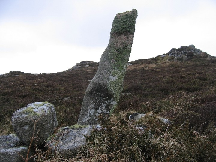
Visited today, and in comparison with Hamish's photo, the stone is currently surrounded by a three feet wide moat of mud at least ten inches deep! I hope the stone is well bedded in.
It's obviously being used as a rubbing stone by the horses in the field - their hoof prints were much in evidence in the mud, hence the depth estimation.
Hopefully LAN will be able to do something about this when the drier weather comes. I'll be raising it with them later this week.
|
Visited this simple bowl barrow yesterday. It stands in the corner of a field above a road junction, and has a large oak tree now growing from it.
There is very little evidence of the surrounding ditch, and very little left of the barrow itself, though English Heritage report it as never having been excavated (see Misc link).
Easily seen from the road (through a hedge/fence), I didn't see any obvious way into the field from the road.
|
 
|
"Despite the close proximity of road construction, the monument survives comparatively well and will contain primary archaeological deposits and some
possibility of evidence for past environmental conditions from the sealed surface beneath the mound and the ditch fills. It is one of few well-
preserved barrows to survive in the county. "
|
  
|

|
  
|
Many thanks to Jane for taking over to see the henge earlier today. As previously stated, this lies in the middle of landfill, on private land. However, we weren't challenged at all and spent some time looking around the henge and watching the birds all around.
I was extremely surprised at the extent of the site - for some reason I'd only expected an arc of stones at the edge of a gravel pit!
Although only partially restored, it's possible to relate to the previous splendour of this place, even amongst all the rubbish. The rabbits have made a real mess of the restored part of the ditch, and there are copious deposits of bones (no feathers) all across the site. I expect the bones have been dropped by the many crows and kites around. However, it looks as if some progress is being made as a large number of pits have been dug, including an outlier close to the circle, presumably ready to receive the stones strewn in the centre of the site. The pits are not evenly spaced, suggesting that they have been based upon previous digs noting the original positions of the stones. I look forward to eventually seeing the porject completed!
|
Visited this early yesterday morning, just before the rain set in. At least, I believe I visited it! As Mr Hamhead says, it's quite featureless out here apart from the copious stones, and climbing up the incline even the field boundary below disappeared from sight.
Parking is possible just to the east of the farm itself. Continue on foot up the lane, turn right and stick to the wall. At the third field boundary (where the gorse peeks over the wall), strike away from the wall at 90 degrees and head up the hill. Look for a clear area amongst a couple of arcs of stones before the crest of the hill , and you're there!
|

|

|
  
|
I went with some friends up to the Rollrights today.
I'm sad to report that following the recent fire damage there, some follow-up damage and a further attack have occurred.
1. The King Stone notice, where previously cracked, has now been broken off completely.
2. The King's Men stone which was previously burnt by the tire attack has been significantly chipped on the top.
3. The warden's hut has again been attacked. Cavity Wall foam was sprayed into the collection box, and also into the locks. This subsequently solidified, breaking the locks and rendering the collection box unusable. An oil fire used by the wardens was lit and placed next to a wooden cabinet and a gas cylinder within the hut, with the obvious intention of causing an explosion. In dousing the fire, the fire service had to substantuially damage the floor of the hut, which is currently unusable by the wardens for overnight stays (and which stank of smoke). These attacks apparently occured on the 9th December according to the warden on duty.
The police are now apparently willing up increase the charge from one of Arson, to Arson with Intent. However, they have no real leads. The only solution may be to install CCTV cameras at the site, which no one really wants to do.
|

|

|
|
Viisted this last week with Mr Hamhead and Scubi63. I wasn't previously aware of this site, but took some photos on a glorious autumn morning and stitched the pano photo together.
|
I'd heard of the recent fire attack at the stones, so decided to pop up and take a look at the damage for myself.
I'd arrived early, so as to avoid the tourists, and had the circle to myself for all of 5 minutes. I nearly cried when I saw the aftermath of the damage, both in the circle and to the King Stone sign.
At least 4 inches of wood ash surrounded the base of the stone at the right of the entrance to the circle, and the entire top was blackened, presumably where the tyre was hung and filled with wood. Looking at the ashes, it was plain that the wood used had been brought deliberately for the attack, rather than just using saplings etc from the adjoining brush, as the wood that hadn't been fully burnt was worked, like short strips of 10mmx2mm. This wasn't a spur of the moment thing, but had obviously been carefully planned.
Across the way, the cast iron sign by the King Stone had also been attacked, looking like it had been set to with a gemmy bar, as the iron was split and buckled.
Luckily, it looks as if the Whispering Knights were left alone.
I've tried to understand the mindset of people who would do such a pointless thing. I've failed. Maybe it was because there was only £7 in the collection box that they also raided?
Apparently the police aren't particularly interested in following this one through, presumably because there's so little to go on. Which means the perps may be encouraged to come back and have another go? I sincerely hope not. Very sad.
|

|
  
|

|
Visited here today on a gloriously sunny Bank Holiday weekend.
Access is fairly straighforward. On the road just sough of the camp, it's possible to pull in by a marked bridleway. Follow the bridleway two fields north, then turn right. The camp is laid out in front of you, enclosed by a fence and gate.
Beware if sheep are in the enclosure (as they were today), as the gate does not meet properly, and it's not possibile to secure it shut - remember the country code?
The camp itself is as JackSprat says, quite impressive in its size. The bank and ditch are still very well defined for the most part.
A most worthwhile stop on what was a pleasant BH drive.
|

|

|
 
|

|
On holiday in Penwith last week, I'd agreed to meet Mr Hamhead for lunch in the Tinners Arms as he was also in the area. Suitable refreshed after a pint and a meal, we set off for our agreed target, Mulfra Quoit. I'd last visited the quoit some 3 years ago, and took the steep approach from Try Farm on that occasion. Today though, we took the much easier (but longer) approach from the north. After a couple of comedy pictures, we discussed the apparent moulding on the underside of the capstone, whether the quoit was ever 'whole', and the alignments with Chysauster and Castle an Dinas (and the time difference between the ages of the sites).
Some of the gorse had been burnt off near the quoit, and investigation to the south uncovered some old field boundary walls, and a possible hut circle. As the weather was closing in from the south, we made our way back to the car, and the heavens opened as if to say "Get orff my hill!". We got.
|

|
 
|
There is supposedly a second circle in the vicinity, known as 'Tregurnow circle', located roughly at SW 437 245. However, I was there last week, and could see no sign of it on the ground (last reported sighting was in the 1970s.)
Lots of interesting stones in the field boundary wall a few yards away, but that's not unusual around these parts.
|
OK, I've tried a couple of times to get here - each time giving up within 100 yards or so of the prize.
My first attempt was along the defined path toward the radio station. Sadly, this got me close, but the barbed wire fencing and waist high gorse combined to thwart me.
Today I tried a different approach. Following the track east from the road, then heading south along what, according to the MAGIC map, is a pathway leading very close to the stone. Unfortunately, the same barbed wire fence continues rght round the area, and the path no longer exists. I did pop over a gate and got into the field though, and the pathway 'sort of' exists, but within a couple of hundred yards of the stone is gobbled up by the encroaching gorse, and as the horseflies were having a good feed on my arm and not wishing to encounter any adders in the gorse, I backed off again.
Back at the car, a local lady was talking to Mikki, explaining that the farmers received a lot of money to fence off the area (despite it being Right to Roam land!), and this had detered the horseriders. Subsequently, the path had become unused and is gradually disappearing. I may well raise this issue with CASPN when I see them tomorrow.
|
|