The Modern Antiquarian
Log in
|
Register
Home
Latest Posts
Forums
Maps
Help
Browse Sites
News
Blog
Contributors
The Books
Select
-
Belgium
Denmark
Eire
France
Germany
Greece
Italy
The Netherlands
Norway
Portugal
Republic of Malta
Spain
Sweden
Switzerland
United Kingdom
County Limerick
Cnoc Greine
Knocsefin
Round Barrow(s)
Knocsefin (Round Barrow(s)) on The Modern Antiquarian, the UK & Ireland's most popular megalithic community website. 2 images, 1 fieldnote, plus information on many more ancient sites nearby and across the UK & Ireland.
Image © Bawn79
Nearest Town:
Cappamore (7km N)
OS Ref (IE):
R752452 /
Sheet: 65
Latitude:
52° 33' 27.57" N
Longitude:
8° 21' 56.53" W
Added by
bawn79
Images (2)
Fieldnotes (1)
0 discussions
Start a topic
Show |
Hide
Web searches for Knocsefin
Flickr
Google
Google Images
The Megalithic Portal
Bing
Stone Pages
Wikipedia
Show map
(inline Google Map)
- Sites within 20 km -
-
Cnoc Greine (0.6km SSE) (3 posts)
Knocksefin (1.26km ENE) (1 post)
Liseen (1.86km NE) (3 posts)
Longstone (2.9km W) (2 posts)
Knockroe (4.68km S) (1 post)
Tuogh (4.87km NNE) (0 posts)
Sarsfields Rock (5.51km ESE) (3 posts)
Cromwell Hill (6.66km SSW) (7 posts)
Rootiagh (6.89km WSW) (1 post)
Rootiagh (7.18km WSW) (3 posts)
Knockeen (7.28km WNW) (1 post)
Longstone (7.48km ESE) (3 posts)
Longstone (7.48km ESE) (1 post)
Longstone (7.48km ESE) (8 posts)
Lodge (8.4km SSW) (4 posts)
Ballynamona (8.78km SW) (4 posts)
Knockroe (9.15km WSW) (3 posts)
Moohane (9.27km WSW) (4 posts)
Hospital (9.33km SSW) (2 posts)
Castlefarm (9.36km SW) (4 posts)
Kilmoylan Upper (9.46km ENE) (3 posts)
Glenbane (9.46km SE) (1 post)
Cloghaunainey (9.66km SW) (1 post)
Knockroe (9.72km W) (7 posts)
Ballybricken East (9.75km W) (4 posts)
Cloonyconry More (9.8km SSE) (4 posts)
Ballybricken East (9.81km W) (2 posts)
Knockroe (9.91km W) (2 posts)
Inch St. Lawrence (9.94km W) (7 posts)
Ballybricken East (9.95km W) (3 posts)
Knockroe (9.98km W) (2 posts)
Brufea (10.05km W) (3 posts)
Ballybricken West (10.14km W) (3 posts)
Coolalough (10.2km SSW) (5 posts)
Inch (10.21km W) (5 posts)
Coolalough (10.25km SSW) (2 posts)
Skahard (10.42km W) (3 posts)
Lough Gur P (10.6km WSW) (1 post)
Lough Gur O (10.61km WSW) (8 posts)
Loughgur (10.79km WSW) (0 posts)
Carraig Aille (10.8km WSW) (7 posts)
Carraig Aille (10.8km WSW) (4 posts)
Cahernahallia (10.84km ENE) (1 post)
Cahernahallia (10.84km ENE) (2 posts)
Highpark (10.94km W) (1 post)
Ballingoola (10.98km WSW) (1 post)
Ballingoola E (10.99km WSW) (1 post)
Ballingoola D (11.02km WSW) (0 posts)
Luddenmore (11.04km W) (5 posts)
Luddenmore (11.04km W) (3 posts)
Ballingoola A (11.04km WSW) (2 posts)
Ballingoola C (11.08km WSW) (1 post)
Highpark (11.09km W) (2 posts)
Highpark (11.1km W) (3 posts)
Ballingoola B (11.12km WSW) (1 post)
Gotoon (11.25km SSW) (2 posts)
Doonglara (Glenbrohane) (11.35km NNW) (1 post)
Highpark (11.36km W) (4 posts)
Coolalough (11.37km SSW) (2 posts)
Entrance to Tir Na Og (11.38km WSW) (3 posts)
Knockfennel (11.44km WSW) (3 posts)
Cnoc Aine (11.46km SW) (6 posts)
Cnoc Aine (11.52km SW) (7 posts)
Knockadoon (11.53km WSW) (1 post)
Knockadoon Circles A + B (11.7km WSW) (1 post)
Old Hags Chair (11.71km WSW) (2 posts)
Knockfennel North (11.72km WSW) (4 posts)
Knockadoon Circle K (11.75km WSW) (5 posts)
Lackanagoneeny (11.78km NE) (4 posts)
Lattin (11.82km ESE) (3 posts)
Lough Gur D (11.88km WSW) (6 posts)
Lough Gur C (11.88km WSW) (17 posts)
Lattin (11.9km SE) (3 posts)
Gorteennacreeagh (11.9km SW) (2 posts)
Stonepark (11.92km W) (2 posts)
Grange / Lios, Lough Gur (11.92km WSW) (87 posts)
Lough Gur Wedge Tomb (11.92km WSW) (26 posts)
Cnoc Aine (12km SW) (3 posts)
Knockfennel (12.04km WSW) (2 posts)
Garranbane (12.09km NNW) (5 posts)
Cnoc Aine (12.13km SW) (2 posts)
Knockfennel (12.13km WSW) (4 posts)
Cnoc Aine (12.21km SW) (1 post)
Rathanny (12.24km SSW) (7 posts)
Ballyconry (12.33km ESE) (2 posts)
Ballyconry (12.35km ESE) (6 posts)
Black Sow’s Bed (12.48km WSW) (6 posts)
The Pillar Stone (12.55km WSW) (8 posts)
Gortnageragh (12.66km ENE) (2 posts)
The Stone Of The Tree (12.79km WSW) (6 posts)
Grange Lios (12.84km WSW) (9 posts)
Grillagh (13.09km SW) (0 posts)
Scraggeen (14.09km NNW) (2 posts)
Rockbarton (14.36km WSW) (3 posts)
Clogher Hill (14.78km S) (2 posts)
Springfield (15.16km E) (2 posts)
Elton (15.51km SSW) (6 posts)
Rathneaveen (15.53km E) (2 posts)
Bruff (15.53km SW) (3 posts)
Ballynilard (15.54km ESE) (4 posts)
Foilycleara (15.6km NE) (3 posts)
Lissard (15.85km SSE) (10 posts)
Rathneaveen (15.9km E) (2 posts)
Clonpet (15.95km ESE) (1 post)
Shanballyedmond (16.19km NE) (17 posts)
Ballinvana (16.21km SSW) (2 posts)
Lissard (16.5km SSE) (3 posts)
Tynacocka (16.71km SW) (2 posts)
Duntryleague Cairn (16.99km SSE) (1 post)
Duntryleague (16.99km SSE) (32 posts)
Ballinscaula (17.02km SSW) (6 posts)
Ballinscaula (17.02km SSW) (2 posts)
Corderry (17.05km SE) (8 posts)
Friarstown (17.06km W) (6 posts)
Shrough (17.17km ESE) (16 posts)
Foilaclug (17.17km ENE) (3 posts)
Reardnogy More (17.21km NNE) (3 posts)
Bawnacouma (17.31km W) (1 post)
Aughsullish SW (17.42km NE) (6 posts)
Baurnadomeeny (17.55km NE) (38 posts)
Aughsullish NW (17.56km NE) (1 post)
Knockshanbrittas (A) (17.56km NE) (6 posts)
Bulgadenhall (17.74km SW) (1 post)
Baurnadomeeny (17.75km NE) (6 posts)
Garracummer (17.97km NE) (8 posts)
Baurnadomeeny (18.03km NE) (4 posts)
Goulmore (18.42km NE) (4 posts)
Ballyfroota (18.81km S) (3 posts)
Rathmore South (18.85km WSW) (3 posts)
Carrignacaubeen (19.02km S) (2 posts)
Ballingarry (19.28km S) (3 posts)
Blackstairs (19.32km ENE) (3 posts)
Blackstairs (19.32km ENE) (4 posts)
Rock an Tarbh (19.33km ESE) (3 posts)
Ballingarry (19.41km S) (1 post)
Knocktwo (19.88km SW) (3 posts)
- Add -
-
Add news
Add an image
Add fieldnotes
Add folklore
Add miscellaneous
Add a link
-
Add a site
Add a nearby facility
Add an alternative name/spelling
Images
(click to view fullsize)
Add an image
Fieldnotes
Add fieldnotes
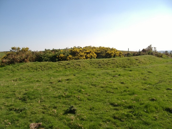
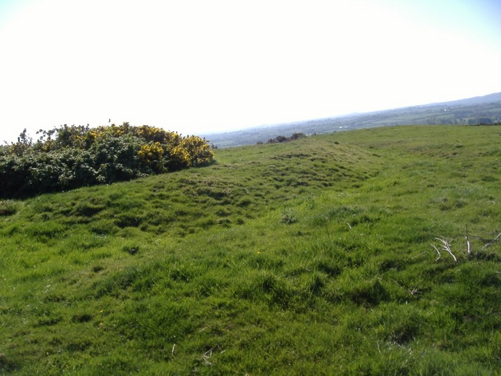
This Barrow is about 32m radius. Half of it is actually destroyed so only a semi-circle remains.
Again this does not appear on the OS map for the area.
Comments (0)
|
Add a comment
|
Permalink
Posted by
bawn79
17th May 2007ce