The Modern Antiquarian
Log in
|
Register
Home
Latest Posts
Forums
Maps
Help
Browse Sites
News
Blog
Contributors
The Books
Select
-
Belgium
Denmark
Eire
France
Germany
Greece
Italy
The Netherlands
Norway
Portugal
Republic of Malta
Spain
Sweden
Switzerland
United Kingdom
England
Northern England
Cumbria
Langdale Axe Factory
Harrison Stickle
Ancient Mine / Quarry
Harrison Stickle (Ancient Mine / Quarry) on The Modern Antiquarian, the UK & Ireland's most popular megalithic community website. 4 images, plus information on many more ancient sites nearby and across the UK & Ireland.
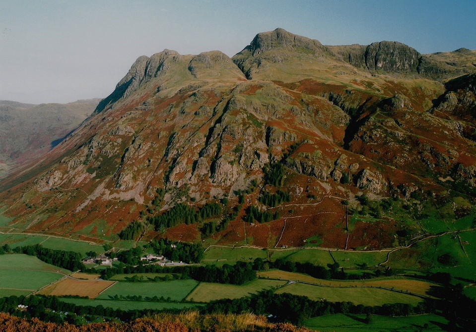
Image © Chris Bickerton
Nearest Town:
Ambleside (9km E)
OS Ref (GB):
NY282072 /
Sheets: 89, 90
Latitude:
54° 27' 17.5" N
Longitude:
3° 6' 27.33" W
Added by
The Eternal
Images (4)
0 discussions
Start a topic
Show |
Hide
Web searches for Harrison Stickle
Flickr
Google
Google Images
MAGIC
The Megalithic Portal
Bing
Stone Pages
Streetmap.co.uk
Wikipedia
Show map
(inline Google Map)
- Sites within 20 km -
-
Thorn Crag (0.3km WSW) (3 posts)
Loft Crag (0.41km WSW) (5 posts)
Langdale Axe Factory (0.8km WSW) (54 posts)
Great Langdale (1.65km SE) (20 posts)
Mickleden Beck (1.92km WSW) (9 posts)
Copt Howe (3.48km E) (72 posts)
Wrynose Pass Stone (3.9km SSE) (5 posts)
Castle Howe, Little Langdale (4.2km SE) (3 posts)
Glaramara Stone Axe Factories (4.8km WNW) (1 post)
Glaramara (Northern) Stone Axe Factory (4.87km WNW) (4 posts)
Elterwater Common (5.4km E) (1 post)
Grasmere (5.61km ENE) (12 posts)
Dunmail Raise (6.35km NE) (13 posts)
Cairn to SW of Hardknott Castle (8.74km SW) (2 posts)
Castle Crag, Borrowdale (9.29km NW) (26 posts)
Lead Pike (9.67km SSW) (3 posts)
Maiden Castle (Wastwater) (9.93km WSW) (5 posts)
Banniside (10.39km SSE) (15 posts)
Boat Howe (11.04km WSW) (14 posts)
Castle Crag, Shoulthwaite (11.71km N) (4 posts)
Low Longrigg (11.81km WSW) (20 posts)
Brat's Hill (11.91km WSW) (32 posts)
White Moss (11.96km WSW) (55 posts)
The Kirkstone (12.04km ENE) (13 posts)
Bleaberry Haws Ringcairn (12.28km S) (7 posts)
Bleaberry Haws Cairn (12.29km S) (11 posts)
Dovedale Henge (12.37km ENE) (23 posts)
Bleaberry Haws Summit Cairn (12.58km S) (4 posts)
Torver High Common Dyke (12.71km S) (1 post)
Bleaberry Haws (12.71km S) (15 posts)
Hird Wood Circle (13.42km E) (17 posts)
Troutbeck Park (14.16km ENE) (7 posts)
Seatallan (14.3km W) (5 posts)
Beckstones (14.44km ENE) (21 posts)
Buttermere (14.64km WNW) (5 posts)
Castlerigg (16.51km N) (359 posts)
High Hugill Settlement (16.68km E) (3 posts)
Grasmoor (16.93km WNW) (4 posts)
Threlkeld Knotts (17.42km NNE) (4 posts)
High Raise (17.66km ENE) (5 posts)
White Borran (18.15km S) (0 posts)
Stockdale Moor (18.17km W) (17 posts)
Mill Rigg Settlement (18.35km E) (1 post)
Sampson's Bratfull (18.35km W) (15 posts)
Low Raise (18.51km ENE) (3 posts)
Floutern Cop (18.56km W) (16 posts)
Monks Graves (18.59km W) (0 posts)
Barnscar (18.79km SW) (19 posts)
Crummock (18.97km WNW) (27 posts)
Rusland (19.14km SE) (8 posts)
Castle Crags, Mardale (19.43km ENE) (4 posts)
Giant's Grave (19.43km S) (20 posts)
Town Bank (19.47km W) (0 posts)
The Coombs, Martindale (19.65km NE) (5 posts)
Whitrow Beck (19.85km SW) (6 posts)
- Facilities within 20 km -
-
The Old Dungeon Ghyll ... (Hotel: 1.1 km SSE)
Great Langdale Campsit... (Camping Site: 1.5 km SSE)
Wainwrights Inn (Pub: 4.8 km ESE)
Travellers Rest (Hotel: 5.7 km ENE)
Scafell Hotel (Hotel: 8 km NNW)
Ruskin Museum (Museum: 9.7 km SSE)
Wasdale Head Inn (Hotel: 9.7 km W)
The Armitt Gallery, Mu... (Museum: 9.7 km E)
Unicorn Inn (Hotel: 9.8 km E)
Sun Hotel (Hotel: 9.8 km SSE)
Queens Hotel (Hotel: 9.8 km E)
Wasdale Head National ... (Camping Site: 9.9 km W)
Scarr Head Farm (Camping Site: 12.5 km SSE)
Hollins Farm Campsite (Camping Site: 12.5 km SW)
The Church House Inn (Pub: 13 km SSE)
Dale Bottom Farm (Camping Site: 14.7 km N)
Side Farm (Camping Site: 14.7 km NE)
Syke Farm (Camping Site: 14.8 km WNW)
Castlerigg Farm (Camping Site: 15.3 km N)
Dog and Gun (Pub: 16.2 km NNW)
Coledale Inn (Hotel: 17 km NNW)
Scotgate Holiday Park (Camping Site: 17 km NNW)
Watermill Inn (Hotel: 18.4 km ESE)
Kirkstile Inn (Pub: 19.7 km WNW)
- Add -
-
Add news
Add an image
Add fieldnotes
Add folklore
Add miscellaneous
Add a link
-
Add a site
Add a nearby facility
Add an alternative name/spelling
Images
(click to view fullsize)
Add an image
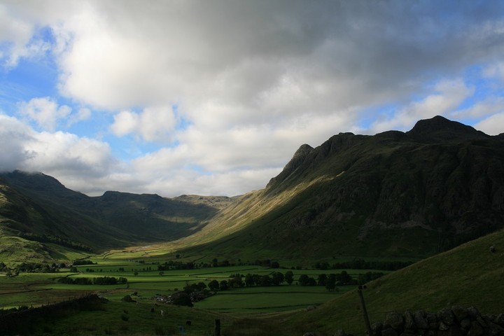
 Image © Chris Bickerton
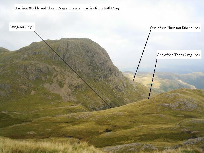