|
|

|
|
Blakeley RaiseStone Circle
|
|
|
|
Images (click to view fullsize) |
|


|
Fieldnotes |
|
|
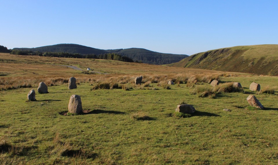
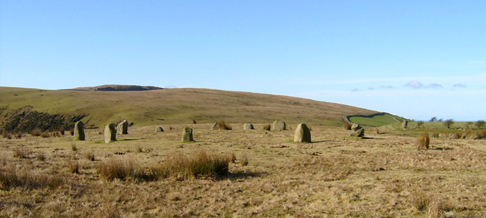
Visited 3.8.14 Directions: Next to a minor road south of Ennerdale Bridge – off the A5086. O/S map required. It is a pretty bleak place up here. Open moorland and a strong wind. On the plus side the stone circle is right next to the road and has decent views to the north. Also, being a Sunday we avoided any ‘Sellafield traffic’ and had the place to ourselves. I don’t know when the stones were re-erected but they don’t seem to have withstood the test of time very well. One stone has fallen, one half-fallen and one stone has been badly worn away around its base by sheep. I don’t think it will be standing for too much longer. The circle was a lot smaller than I was expecting but pleasant all the same. The site has a ‘remote feel’ about it despite the closeness of the road. I quite liked it here. Well worth a visit but make sure you bring a good map in order to find it. |
Posted by CARL 6th August 2014ce |
|
I can report that the Sellafield traffic still use the road beside the stones as a high speed short cut home. Sadly I did not read the notes before myself and Mrs Hamhead decided to drive up there at around five o'clock last Wednesday afternoon!!! It took us a while to work out where all these single men were coming from at great speed.... We had been enjoying a fantastic walk beside Ennerdale in the sunshine when I noticed Stone Circle on the OS map...shall we go I said...do i have a choice? said Mrs H. I realise I am spoilt with all the circles down here in Cornwall and the nearby racetrack was a little off putting but i coudn't get too excited about Blakeley....its nothing to do with the fact that it might be a modern recreation...most circles in Cornwall have been re-erected at some time...it just didn't have that something.. Still, its easy to get to (unless you time it wrong) and it is a quiet retreat after the madness of the Lakes. We drove a little further south along the road and parked up at the gates to a plantation. From here we walked up the hill opposite...great views from the top over to the Isle of Man and Scotland. |
20th April 2010ce |
|
Supposedly, this is a reconstructed site. Perfectly manicured lawns, courtesy of the local Herdwick sheep, and manure to keep the grass growing. This is the land that could well be described as the "arsehole of nowhere", not that I wouldn't like to live there. The west Cumbrian coast is the hardest part of England to get to. Even from the central Lakes it's at least an hour plus to get to Kinniside, sorry Blakeley Raise. The new name has come from the small fell behind. It' known locally as Kinniside. If you get there at the right time of day, i.e. when the minority of dickheads who work at Sellafield aren't going to, or coming from work at high speed on a narrow road, often on the wrong side, then it's bliss, otherwise don't bother, as the chances of a crash are high. As are the chances of a crash on the southern approaches from the M6, to-whit, the A590 (740 casualties in the last 5 years). Enough doom. The circle is set high above Cleator Moor, which can be seen down to the west. Sellafield's (it's safe, honest) chimneys and cooling towers spoil the view of the Irish Sea. To the N and NW lovely fells rise up, as the do immediately behind. You can walk these heights all day without seeing a soul. As for the circle, well the story of the reconstruction (see my notes in the miscellaneous) sort of destroys the illusion of the perfect setting. How can we really be sure they're the right stones in the right holes? It changes the atmosphere and feeling of the site for me. |
 Posted by The Eternal
1st October 2006ce |
|
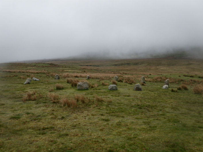
Just returned from a weekend on the West Cumbrian coast, where my main aims were to get to Grey Croft and Blakeley Raise. Mid summer, the weekend following the hottest week of the year so far and what happens? RAIN AND WIND...and lots of it. Grey Croft was a no-no as the wind and rain were just too much (we had packed expecting light showers with mainly sunny intervals, as the BBC had promised us!) However, we did get to Blakeley Raise, following the road over the moors from Calder Bridge to Ennerdale. We nearly missed the site though, as the mist was so thick and low, we could barely see 10 ft in front of us. Mark wouldn't even get out of the van, it was torrential rain but I risked it and I'm glad I did, such a beautiful site. I'll post the pix I managed to take, not because they are exceptional, but to show all you lucky blighters who seem to have been there in the sun, what the stones look like shrouded in mist and rain - very atmospheric! |
 Posted by Vicster
9th July 2006ce |
|
My girlfriend & I both found this circle so cute, but masses of evidence the stones have been re-erected (& possible moved) over the years. Didn't notice any dogs, just evidence of the local riding stables trotting through! Beautiful clear day today. Even Isle of Man clearly visible from the hillside. Notes on how to find the site: From North - from the A5086 to Ennerdale Bridge, follow all signposts to Calder Bridge. Once you've past the turn to the stables and rise up onto the moor, circle is on your left right by the roadside. The road continues over the moor, dropping down to Sellafield (say a curse for me). From South - from the A595 turn right as you approach Calder Bridge following the signposts to Ennerdale. This is a steep hill - cyclist beware - which takes you up over the moors. As you drop back down (after quite a few miles) the circle is on your right. I believe there are toilets (at least an all day pub) in Ennerdale Bridge. |
10th April 2006ce Edited 10th April 2006ce |
| A very chilly Sunday morning in February would normally find me happily tucked under the duvet but it was so crisp and clear (OK, make that freezing) that there was no one else around, no traffic for miles before or after - just a glorious spot. Checking TMA book version when I got home, the "3 miles from the junction" is actually only 1½ - but it's not like you can miss it driving past! |
21st February 2005ce |
| Reminds me of The Nine Ladies of Stanton Moor which I visit reguarly. Right next to the road high up on the moor so if you get on the right road [which I did at the 3rd attempt] you can't miss it. Small stones in comparison with other circles in this area. |
Posted by jdellis 13th October 2003ce Edited 14th October 2003ce |
|
This is a nice little circle on a small plateau with the hill of Blakeley Raise behind it to the southeast. The books say 11 stones, the pictures show 11 stones, but in my notes I’ve got 12 stones (?!) – must have been some kind of cosmic vibe thing going on… I managed to solve the mystery of the ‘Hounds of Blakeley’ though. As I arrived at the site I noticed a number of cars had congregated over on Low Cock How and there was a loud sound of barking and excited dogs. After a while the dogs were lined up and released – I thought they were just going to race to the bottom of the hill or something but as they disappeared out of sight in a dip in the land for a few seconds I suddenly realised they were probably heading in my direction. And so they were. Now, I’m usually wary of 4-legged beasts, especially when it’s a pack of 20 large dogs which would normally have me diving for cover, but I had no time to move to safety. Sure enough the dogs hurtled across the road and shot straight past the circle (completely ignoring me) and belted up the side of Blakeley Raise, I don’t know how fast they were running but they were over the hill in a couple of minutes at most. I estimated it would have taken me at least a knackering quarter of an hour to do the same climb. About 20 minutes later while I was eating a sarnie I noticed the dogs running down the north side of Flat Fell and back to Low Cock How. After some research I found I had been watching ‘hound trailing’ a 200 year old Cumbrian tradition involving dogs following an aniseed trail over about 7 miles of fells and hills and I have to admit it was a pretty damn awesome sight. |
 Posted by Chris Collyer
21st April 2003ce |
|
A fantastic circle , full of great views and great mystery. bagpipes? screaming shepherds? We arrived and out of nowhere came 6 HUGE hounds, they bounded around and became abit scary at first so we retreated to the car (like big scaredy cats). they bounded off so we again got out...they turned up again!This happened afew times I just ignored them after awhile, it was all quite strange as there was no-one around for miles, it seemed as if they were guarding it. This circle is a really beautiful, quite ignored site (people just tend to drive past). I wasn't expecting it to be so well preserved and it brightened up a cold windy october morning. fantastic! |
Posted by pixie 17th February 2002ce |
| MY WIFE AND MYSELF VISITED THIS CIRCLE OF SMALLISH STONES THIS AFTERNOON. THE SUN WAS SHINING ON A BEAUTIFUL CRISP DAY, 5 HORSES WERE ROAMING FREELY AND THERE WAS THE SOUND OF BAGPIPES!!!! DON'T KNOW WHERE FROM, ASSUMED SOMEONE HAD BEEN THROWN OUT OF THERE HOME AND WERE MADE TO PRACTICE IN THE NEAR BY FOREST! ALTHOUGH THE STONES HAVE BEEN RESET IT IS STILL IMPRESSIVE. NICE SETTING AS WELL. |
Posted by CAOMHIN 17th February 2001ce |
| Me and Tess on a megalithic odessy, found our way up to the moor and there they were. A sweet little circle perfectly formed, lovely moorland and a screaming shepherd, (I thought they whistled and ting, this dude was screaming at his dog, then the sheep all trooped down in a Mackenzie Thorpe stylee. Spent fireworks littered the site must've been a good party but they could have picked their shit up. Sweet circle. |
 Posted by fitzcoraldo
20th November 2000ce Edited 11th January 2004ce |
Miscellaneous |
|
|
This site has always been known locally as Kinniside Stone Circle. Blakeley Raise being the fell to the east (ish). I read, in a non-archaeological source, that there were originally twelve stones, and that they were taken by local farmers for use as gate posts. After excavation of the site, the stone holes were measured, and after, the original stones were located and set back in their sockets, thus restoring the circle to its "original" condition. The book that states this doesn't quote a source. The book also states that the road that passes the circle is the same track as that of a Roman road that once existed. The author then goes on to state that this further proves the Romans' respect for native religious sites. A little further to the south, on the flanks of Lank Rigg, the next fell, further evidence of prehistoric settlement and burial exists. |
Posted by The Eternal 22nd April 2005ce |
|
Just to add to Rhiannon's comment. I think it is worth quoting Burl directly as this is a good example of the wit & wisdom of the mighty fella. "happily, the deterrent of a line of sharp-edged kerbstones at the roadside has ended this conversion of a ritual circle into a napkin ring". From Carnac to Callanish Aubrey Burl Yale University Press 1993 |
Posted by fitzcoraldo 11th January 2004ce |
| According to Aubrey Burl, people used to drive their cars into the middle of the circle and get out their picnic hampers. Tsk. These days such activities are a bit more tricky as there's a big kerb at the road nearby (which I only vaguely noticed at the time, despite it being such an incongruous thing, in the middle of a moor). |
 Posted by Rhiannon
8th January 2003ce |
|
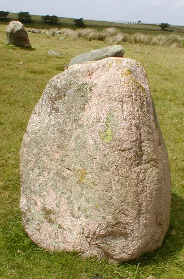
This site is 3 1/2 miles from Egremont and straight off the main road. Burl describes the circle as 11 small stones 54 ft in diameter. they were re-rected in 1925, but there is some confusion as to what the 'partial restoration' actually involved. Either replacement of 8 stones that were removed to make a gate or just re-erection of stones in their original postions. Easy to get to and worth visiting. |
Posted by pixie 17th February 2002ce |
Links |
|
Extreme Stonefeelers' World of Hard Rock & Standing StonesPics of Blakeley Raise circle |
 Posted by new abbey
26th May 2010ce Edited 27th May 2010ce |
Megalithic Walks: Blakeley RaiseAnother page from this fruitful and informative Web site, this time containing three photographs of Blakey Raise, directions and a short description. I have to admit, I had no idea it was restored before I read this page. |
 Posted by Kammer
3rd July 2003ce Edited 3rd July 2003ce |